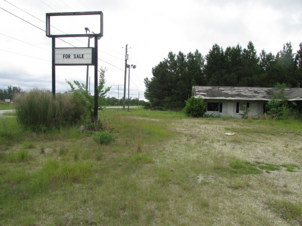
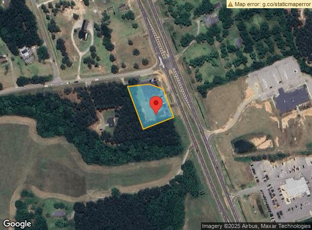
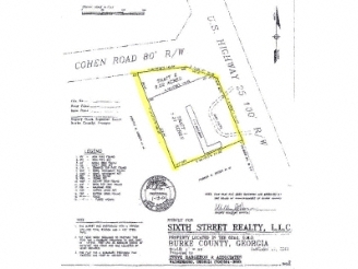
Property Record
561 Us Highway 25 N, Waynesboro, GA 30830
NEARBY LISTINGS FOR SALE OR LEASE
Property Detail
561 Us Highway 25 N
064-035
COHEN RD/HWY 25
Commercialnec
Burke
X
Georgia
13033C0306C
1.10 AC
2024
Burke County
2024
Augusta/Richmond County
950400
Augusta-Richmond County, GA-SC
1,120 SF
DEMOGRAPHICS near 561 Us Highway 25 N
1 Mile
3 Mile
5 Mile
2024 Total Population
353
6,240
9,303
2029 Population
348
6,177
9,175
Pop Growth 2024-2029
(1.42%)
(1.01%)
(1.38%)
Average Age
38
38
39
2024 Total Households
135
2,477
3,679
HH Growth 2024-2029
(0.74%)
(1.01%)
(1.39%)
Median Household Inc
$43,749
$42,268
$45,656
Avg Household Size
2.50
2.50
2.50
2024 Avg HH Vehicles
2.00
2.00
2.00
Median Home Value
$205,000
$131,832
$144,755
Median Year Built
1981
1979
1980
Nearby Places
- Restaurants
- Banks
- Shops
- Fitness
- Groceries
PUBLIC TRANSPORTATION
AIRPORT
Augusta Regional at Bush Field
DRIVE
WALK
Distance
Augusta Regional at Bush Field
36 min
24.5 mi
Freight Ports
Georgia Ports - Savannah
DRIVE
WALK
Distance
Georgia Ports - Savannah
122 min
93.5 mi
Nearby Properties
Address
Land Use
TOTAL SIZE
Lot Size
Zoning
Address
Land Use
TOTAL SIZE
Lot Size
Zoning
64,814 SF
1.97 AC
C-1
Address
Land Use
TOTAL SIZE
Lot Size
Zoning
154,434 SF
30 AC
I-1
Address
Land Use
TOTAL SIZE
Lot Size
Zoning
49.52 AC
I-1
Address
Land Use
TOTAL SIZE
Lot Size
Zoning
200,000 SF
20.33 AC
I-2
Address
Land Use
TOTAL SIZE
Lot Size
Zoning
99,263 SF
11.42 AC
I-1
Address
Land Use
TOTAL SIZE
Lot Size
Zoning
120,960 SF
23.12 AC
I-2
Address
Land Use
TOTAL SIZE
Lot Size
Zoning
131,520 SF
22.32 AC
I-1
Address
Land Use
TOTAL SIZE
Lot Size
Zoning
108,300 SF
13.68 AC
C-2
Address
Land Use
TOTAL SIZE
Lot Size
Zoning
10,120 SF
2 AC
C-2
Address
Land Use
TOTAL SIZE
Lot Size
Zoning
22,320 SF
3.23 AC
C-1
Address
Land Use
TOTAL SIZE
Lot Size
Zoning
72,619 SF
18.34 AC
R-3
Address
Land Use
TOTAL SIZE
Lot Size
Zoning
171,224 SF
7.90 AC
I-2
Address
Land Use
TOTAL SIZE
Lot Size
Zoning
3,102 SF
6.90 AC
R-3
Address
Land Use
TOTAL SIZE
Lot Size
Zoning
67,760 SF
Address
Land Use
TOTAL SIZE
Lot Size
Zoning
25,600 SF
6.33 AC
C-2
Address
Land Use
TOTAL SIZE
Lot Size
Zoning
4,200 SF
4.33 AC
R-3
Address
Land Use
TOTAL SIZE
Lot Size
Zoning
5,124 SF
3.75 AC
R-3
Address
Land Use
TOTAL SIZE
Lot Size
Zoning
18,600 SF
3 AC
C-2
Address
Land Use
TOTAL SIZE
Lot Size
Zoning
10.84 AC
C-2
Address
Land Use
TOTAL SIZE
Lot Size
Zoning
44,500 SF
5.15 AC
C-2
Address
Land Use
TOTAL SIZE
Lot Size
Zoning
898.50 AC
A1
Address
Land Use
TOTAL SIZE
Lot Size
Zoning
8,868 SF
17.24 AC
OI
Address
Land Use
TOTAL SIZE
Lot Size
Zoning
13,362 SF
1.48 AC
C-2
Address
Land Use
TOTAL SIZE
Lot Size
Zoning
1,625 SF
7.50 AC
C-2
Address
Land Use
TOTAL SIZE
Lot Size
Zoning
2,576 SF
5.94 AC
R-3
Address
Land Use
TOTAL SIZE
Lot Size
Zoning
17,680 SF
5.50 AC
C-2
Address
Land Use
TOTAL SIZE
Lot Size
Zoning
6.60 AC
P
Address
Land Use
TOTAL SIZE
Lot Size
Zoning
0.94 AC
C-1
Address
Land Use
TOTAL SIZE
Lot Size
Zoning
7,144 SF
4.61 AC
CC
Address
Land Use
TOTAL SIZE
Lot Size
Zoning
183,158 SF
45.92 AC
I-2
The World's #1 Commercial Real Estate Marketplace
Connect with us
© 2025 CoStar Group
The information above has been obtained from sources believed reliable. While we do not doubt its accuracy we have not verified it and make no guarantee, warranty or representation about it. It is your responsibility to independently confirm its accuracy and completeness. Any projections, opinions, assumptions, or estimates used are for example only and do not represent the current or future performance of the property. The value of this transaction to you depends on tax and other factors which should be evaluated by your tax, financial, and legal advisors. You and your advisors should conduct a careful, independent investigation of the property to determine to your satisfaction the suitability of the property for your needs.