Property Record
5615 W Sunset Hwy, Spokane, WA 99224


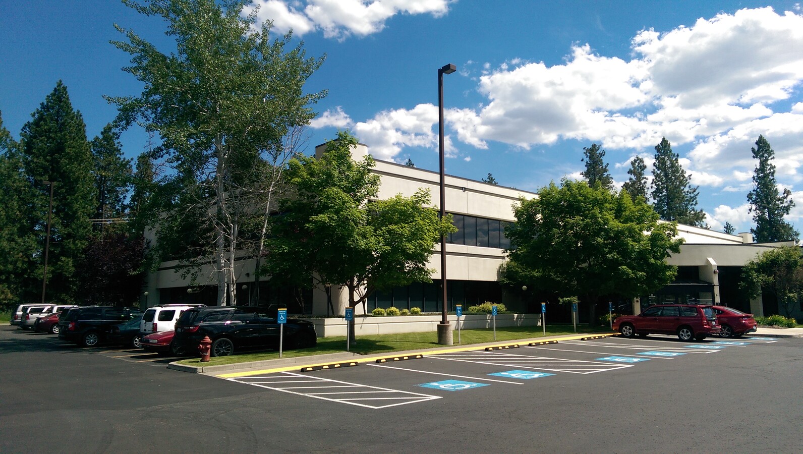
This Property Is For Sale
NEARBY LISTINGS FOR SALE OR LEASE
Property Detail
5615 W Sunset Hwy
25272.9167
27-25-42 PTN OF THE NW1/4 OF THE NW1/4 DAF; BEG AT THE NE COR OF SD NW1/4 TH S 00DEG 15MIN 07SDS W, ALG THE E LN OF SD NW1/4 62.97FT TO THE A LN OF SUNSET HWY & THE POB; TH CONT S ALG THE E LN SD1/4 790FT TO A PNT ON A 415FT RADIUS NONTANGENT CURVE T
Financialbuilding
Spokane
X
Washington
53063C0538D
6.67 AC
2025
West Plains
2024
Spokane
013700
Spokane-Spokane Valley, WA
38,392 SF
DEMOGRAPHICS near 5615 W Sunset Hwy
1 Mile
3 Mile
5 Mile
2024 Total Population
1,371
25,665
119,188
2029 Population
1,495
27,577
127,144
Pop Growth 2024-2029
+ 9.04%
+ 7.45%
+ 6.68%
Average Age
40
40
39
2024 Total Households
653
12,466
50,136
HH Growth 2024-2029
+ 9.49%
+ 7.72%
+ 7.07%
Median Household Inc
$71,083
$53,923
$60,057
Avg Household Size
2.10
2.00
2.20
2024 Avg HH Vehicles
2.00
2.00
2.00
Median Home Value
$423,611
$345,780
$353,354
Median Year Built
1998
1972
1959
Nearby Places
- Restaurants
- Banks
- Shops
- Fitness
- Groceries
PUBLIC TRANSPORTATION
COMMUTER RAIL
Spokane (Empire Builder - Amtrak)
DRIVE
WALK
Distance
Spokane (Empire Builder - Amtrak)
10 min
4.3 mi
AIRPORT
Spokane International
DRIVE
WALK
Distance
Spokane International
7 min
3.1 mi
Freight Ports
Port of Everett
DRIVE
WALK
Distance
Port of Everett
336 min
299.0 mi
Nearby Properties
Address
Land Use
TOTAL SIZE
Lot Size
Zoning
Address
Land Use
TOTAL SIZE
Lot Size
Zoning
831,429 SF
119.79 AC
Address
Land Use
TOTAL SIZE
Lot Size
Zoning
703,222 SF
281.88 AC
LI
Address
Land Use
TOTAL SIZE
Lot Size
Zoning
771,910 SF
646.44 AC
Address
Land Use
TOTAL SIZE
Lot Size
Zoning
118,996 SF
8.21 AC
LI
Address
Land Use
TOTAL SIZE
Lot Size
Zoning
228,981 SF
5.32 AC
RHD
Address
Land Use
TOTAL SIZE
Lot Size
Zoning
236,105 SF
5.01 AC
OR
Address
Land Use
TOTAL SIZE
Lot Size
Zoning
122,949 SF
11.07 AC
LI
Address
Land Use
TOTAL SIZE
Lot Size
Zoning
314,707 SF
16 AC
LI
Address
Land Use
TOTAL SIZE
Lot Size
Zoning
177,707 SF
44.44 AC
LI
Address
Land Use
TOTAL SIZE
Lot Size
Zoning
159,706 SF
918.26 AC
LI
Address
Land Use
TOTAL SIZE
Lot Size
Zoning
59,171 SF
10.12 AC
Address
Land Use
TOTAL SIZE
Lot Size
Zoning
104,889 SF
21.60 AC
LI
Address
Land Use
TOTAL SIZE
Lot Size
Zoning
172,140 SF
70.04 AC
RHD
Address
Land Use
TOTAL SIZE
Lot Size
Zoning
238,830 SF
19.75 AC
LI
Address
Land Use
TOTAL SIZE
Lot Size
Zoning
82,519 SF
1.86 AC
RHD
Address
Land Use
TOTAL SIZE
Lot Size
Zoning
387,963 SF
49.93 AC
LI
Address
Land Use
TOTAL SIZE
Lot Size
Zoning
23,494 SF
8.32 AC
LI
Address
Land Use
TOTAL SIZE
Lot Size
Zoning
25,674 SF
2.34 AC
RHD
Address
Land Use
TOTAL SIZE
Lot Size
Zoning
101,970 SF
7.88 AC
LI
Address
Land Use
TOTAL SIZE
Lot Size
Zoning
32,594 SF
4.69 AC
HDR
Address
Land Use
TOTAL SIZE
Lot Size
Zoning
29,726 SF
9.30 AC
RHD
Address
Land Use
TOTAL SIZE
Lot Size
Zoning
88,000 SF
4.30 AC
CB
Address
Land Use
TOTAL SIZE
Lot Size
Zoning
88,824 SF
3.77 AC
RHD
Address
Land Use
TOTAL SIZE
Lot Size
Zoning
73,160 SF
3.56 AC
CB
Address
Land Use
TOTAL SIZE
Lot Size
Zoning
46,696 SF
30.75 AC
LI
Address
Land Use
TOTAL SIZE
Lot Size
Zoning
53,793 SF
5.59 AC
LI
Address
Land Use
TOTAL SIZE
Lot Size
Zoning
50,400 SF
29.57 AC
RHD
Address
Land Use
TOTAL SIZE
Lot Size
Zoning
49,251 SF
14.04 AC
LDR
Address
Land Use
TOTAL SIZE
Lot Size
Zoning
85,258 SF
7.58 AC
OR
Address
Land Use
TOTAL SIZE
Lot Size
Zoning
156,190 SF
13.89 AC
LI
The World's #1 Commercial Real Estate Marketplace
Connect with us
© 2025 CoStar Group
The information above has been obtained from sources believed reliable. While we do not doubt its accuracy we have not verified it and make no guarantee, warranty or representation about it. It is your responsibility to independently confirm its accuracy and completeness. Any projections, opinions, assumptions, or estimates used are for example only and do not represent the current or future performance of the property. The value of this transaction to you depends on tax and other factors which should be evaluated by your tax, financial, and legal advisors. You and your advisors should conduct a careful, independent investigation of the property to determine to your satisfaction the suitability of the property for your needs.