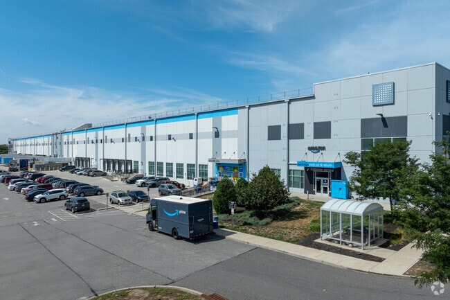
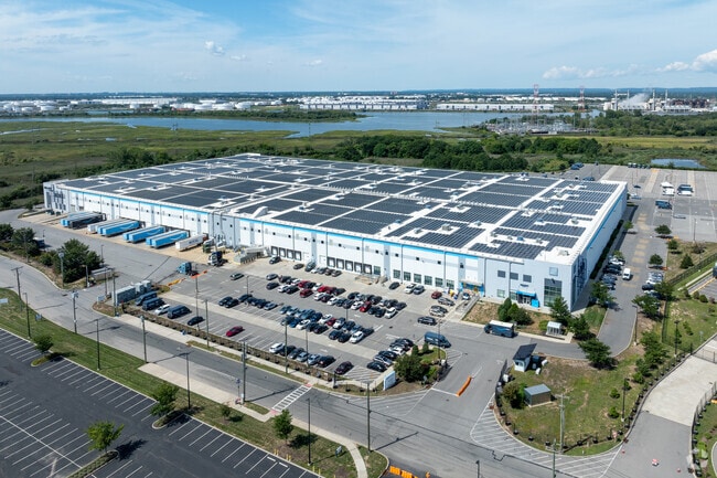
Property Record
566 Gulf Ave, Staten Island, NY 10314

Property Detail
566 Gulf Ave
01760-0025
Richmond
Warehouse
New York
M3-1
25
AE The base floodplain where base flood elevations are provided. AE Zones are now used on new format FIRMs instead of A1-A30 Zones.
33.26 AC
2025
Staten Island
2026
Long Island (New York)
029102
New York-Jersey City-White Plains, NY-NJ
450,000 SF
NEARBY LISTINGS FOR SALE OR LEASE
DEMOGRAPHICS near 566 Gulf Ave
1 mile
3 mile
5 mile
2025 Total Population
403
152,339
550,092
2030 Population
405
152,404
560,630
Pop Growth 2025-2030
+ 0.50%
+ 0.04%
+ 1.92%
Average Age
40
39
40
2025 Total Households
151
50,328
191,896
HH Growth 2025-2030
+ 0.66%
+ 0.10%
+ 2.09%
Median Household Inc
$81,579
$87,745
$87,390
Avg Household Size
2.70
2.90
2.80
2025 Avg HH Vehicles
1.00
2.00
2.00
Median Home Value
$245,945
$639,966
$608,143
Median Year Built
1991
1972
1967
Nearby Places
Map Layers
Map Styles
 Street
 Aerial
Layers
 Traffic
 Biking
Places
Listings with unknown addresses are not visible on the map
- Restaurants
- Banks
- Shops
- Fitness
- Groceries
SALE & LEASE HISTORY
LISTING DATE
SALE/LEASE

Nov 07, 2017
For Lease
Nearby Properties
Address
Land Use
TOTAL SIZE
Lot Size
Zoning
Address
Land Use
TOTAL SIZE
Lot Size
Zoning
28.40 AC
Address
Land Use
TOTAL SIZE
Lot Size
Zoning
196.03 AC
HIA
Address
Land Use
TOTAL SIZE
Lot Size
Zoning
633,280 SF
202.90 AC
R3-2
Address
Land Use
TOTAL SIZE
Lot Size
Zoning
2.21 AC
Address
Land Use
TOTAL SIZE
Lot Size
Zoning
149.68 AC
Address
Land Use
TOTAL SIZE
Lot Size
Zoning
1,258,042 SF
14.47 AC
C4-1
Address
Land Use
TOTAL SIZE
Lot Size
Zoning
91,760 SF
210.43 AC
M3-1
Address
Land Use
TOTAL SIZE
Lot Size
Zoning
102.29 AC
Address
Land Use
TOTAL SIZE
Lot Size
Zoning
20.10 AC
Address
Land Use
TOTAL SIZE
Lot Size
Zoning
Address
Land Use
TOTAL SIZE
Lot Size
Zoning
365,784 SF
12.73 AC
HIA
Address
Land Use
TOTAL SIZE
Lot Size
Zoning
3,500,000 SF
11.97 AC
MRC2
Address
Land Use
TOTAL SIZE
Lot Size
Zoning
39.64 AC
Address
Land Use
TOTAL SIZE
Lot Size
Zoning
566,000 SF
103.31 AC
R3-2
Address
Land Use
TOTAL SIZE
Lot Size
Zoning
6,188,000 SF
8.18 AC
Address
Land Use
TOTAL SIZE
Lot Size
Zoning
12.46 AC
Address
Land Use
TOTAL SIZE
Lot Size
Zoning
90.28 AC
Address
Land Use
TOTAL SIZE
Lot Size
Zoning
11.14 AC
Address
Land Use
TOTAL SIZE
Lot Size
Zoning
855,000 SF
48.74 AC
M3-1
Address
Land Use
TOTAL SIZE
Lot Size
Zoning
10 SF
9.18 AC
Address
Land Use
TOTAL SIZE
Lot Size
Zoning
263,925 SF
11.98 AC
R50
Address
Land Use
TOTAL SIZE
Lot Size
Zoning
7.24 AC
Address
Land Use
TOTAL SIZE
Lot Size
Zoning
24.19 AC
Address
Land Use
TOTAL SIZE
Lot Size
Zoning
5,214 SF
93 AC
M3-1
Address
Land Use
TOTAL SIZE
Lot Size
Zoning
21,120 SF
14.45 AC
R50
Address
Land Use
TOTAL SIZE
Lot Size
Zoning
131.25 AC
PARK
Address
Land Use
TOTAL SIZE
Lot Size
Zoning
2.38 AC
Address
Land Use
TOTAL SIZE
Lot Size
Zoning
970,000 SF
55.25 AC
M3-1
Address
Land Use
TOTAL SIZE
Lot Size
Zoning
195,395 SF
12.04 AC
R3-2
Address
Land Use
TOTAL SIZE
Lot Size
Zoning
992 SF
37.40 AC
The World's #1 Commercial Real Estate Marketplace
Connect with us
© 2026 CoStar Group
The information above has been obtained from sources believed reliable. While we do not doubt its accuracy we have not verified it and make no guarantee, warranty or representation about it. It is your responsibility to independently confirm its accuracy and completeness. Any projections, opinions, assumptions, or estimates used are for example only and do not represent the current or future performance of the property. The value of this transaction to you depends on tax and other factors which should be evaluated by your tax, financial, and legal advisors. You and your advisors should conduct a careful, independent investigation of the property to determine to your satisfaction the suitability of the property for your needs.