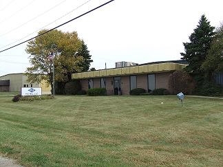
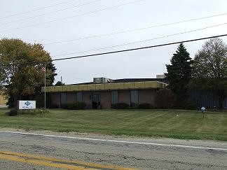
Property Record
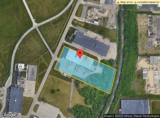
5660 Falcon Rd, Rockford, IL 61109
NEARBY LISTINGS FOR SALE OR LEASE
Property Detail
5660 Falcon Rd
15-14-402-005
LEASE I-25 PT NW1/4 SE1/4 SEC SEC: 14TWP: 43 RANGE: 1 ACRES: 4.17
Industrialgeneral
Winnebago
X
Illinois
17201C0379E
43
2022
4.17 AC
2022
I-39 Cor/Winnebago Cy
980000
Chicago
38,881 SF
Rockford, IL
DEMOGRAPHICS near 5660 Falcon Rd
1 Mile
3 Mile
5 Mile
2024 Total Population
703
20,051
74,377
2029 Population
693
19,859
73,551
Pop Growth 2024-2029
(1.42%)
(0.96%)
(1.11%)
Average Age
44
40
38
2024 Total Households
288
7,920
29,732
HH Growth 2024-2029
(1.74%)
(0.90%)
(1.09%)
Median Household Inc
$43,583
$50,336
$43,695
Avg Household Size
2.40
2.50
2.40
2024 Avg HH Vehicles
2.00
2.00
2.00
Median Home Value
$115,151
$108,422
$90,066
Median Year Built
1969
1969
1961
Nearby Places
- Restaurants
- Banks
- Shops
- Fitness
- Groceries
PUBLIC TRANSPORTATION
AIRPORT
Chicago/Rockford International
DRIVE
WALK
Distance
Chicago/Rockford International
8 min
3.0 mi
Freight Ports
Port Milwaukee
DRIVE
WALK
Distance
Port Milwaukee
117 min
99.0 mi
SALE & LEASE HISTORY
LISTING DATE
SALE/LEASE

Sep 23, 2016
For Sale
Nearby Properties
Address
Land Use
TOTAL SIZE
Lot Size
Zoning
Address
Land Use
TOTAL SIZE
Lot Size
Zoning
555,920 SF
37.99 AC
I2
Address
Land Use
TOTAL SIZE
Lot Size
Zoning
291,074 SF
10.97 AC
I3
Address
Land Use
TOTAL SIZE
Lot Size
Zoning
189,455 SF
10.99 AC
I3
Address
Land Use
TOTAL SIZE
Lot Size
Zoning
173,185 SF
5.97 AC
I3
Address
Land Use
TOTAL SIZE
Lot Size
Zoning
192,476 SF
30.63 AC
I2
Address
Land Use
TOTAL SIZE
Lot Size
Zoning
192,575 SF
46.19 AC
I1
Address
Land Use
TOTAL SIZE
Lot Size
Zoning
623,379 SF
35.15 AC
I3
Address
Land Use
TOTAL SIZE
Lot Size
Zoning
189,568 SF
12.68 AC
I1
Address
Land Use
TOTAL SIZE
Lot Size
Zoning
152,100 SF
4.19 AC
I2
Address
Land Use
TOTAL SIZE
Lot Size
Zoning
58,750 SF
11.25 AC
I1
Address
Land Use
TOTAL SIZE
Lot Size
Zoning
216,549 SF
9.18 AC
I2
Address
Land Use
TOTAL SIZE
Lot Size
Zoning
2,975 SF
5.42 AC
I2
Address
Land Use
TOTAL SIZE
Lot Size
Zoning
212,574 SF
9.57 AC
I3
Address
Land Use
TOTAL SIZE
Lot Size
Zoning
146,722 SF
22.95 AC
I3
Address
Land Use
TOTAL SIZE
Lot Size
Zoning
151,360 SF
8.13 AC
I1
Address
Land Use
TOTAL SIZE
Lot Size
Zoning
578,593 SF
47.65 AC
I3
Address
Land Use
TOTAL SIZE
Lot Size
Zoning
144,088 SF
12.01 AC
I1
Address
Land Use
TOTAL SIZE
Lot Size
Zoning
142,716 SF
26.80 AC
R2
Address
Land Use
TOTAL SIZE
Lot Size
Zoning
187,025 SF
12.82 AC
I3
Address
Land Use
TOTAL SIZE
Lot Size
Zoning
92,245 SF
5.67 AC
I3
Address
Land Use
TOTAL SIZE
Lot Size
Zoning
206,185 SF
21.09 AC
I3
Address
Land Use
TOTAL SIZE
Lot Size
Zoning
165,326 SF
26.32 AC
I3
Address
Land Use
TOTAL SIZE
Lot Size
Zoning
203,450 SF
31.79 AC
I3
Address
Land Use
TOTAL SIZE
Lot Size
Zoning
89,600 SF
0.72 AC
I2
Address
Land Use
TOTAL SIZE
Lot Size
Zoning
80,884 SF
5.34 AC
I1
Address
Land Use
TOTAL SIZE
Lot Size
Zoning
79,642 SF
10.56 AC
I1
Address
Land Use
TOTAL SIZE
Lot Size
Zoning
78,334 SF
9.78 AC
I3
Address
Land Use
TOTAL SIZE
Lot Size
Zoning
79,779 SF
17.50 AC
I2
Address
Land Use
TOTAL SIZE
Lot Size
Zoning
100,080 SF
0.85 AC
I2
Address
Land Use
TOTAL SIZE
Lot Size
Zoning
102,065 SF
9.50 AC
I2
The World's #1 Commercial Real Estate Marketplace
Connect with us
© 2025 CoStar Group
The information above has been obtained from sources believed reliable. While we do not doubt its accuracy we have not verified it and make no guarantee, warranty or representation about it. It is your responsibility to independently confirm its accuracy and completeness. Any projections, opinions, assumptions, or estimates used are for example only and do not represent the current or future performance of the property. The value of this transaction to you depends on tax and other factors which should be evaluated by your tax, financial, and legal advisors. You and your advisors should conduct a careful, independent investigation of the property to determine to your satisfaction the suitability of the property for your needs.