Property Record
56773 Frontage Rd, Strasburg, CO 80136
NEARBY LISTINGS FOR SALE OR LEASE
-
-
View all Strasburg listings for sale on LoopNet.com
Property Detail
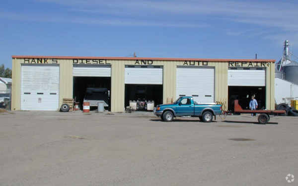
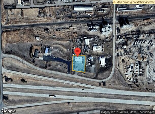
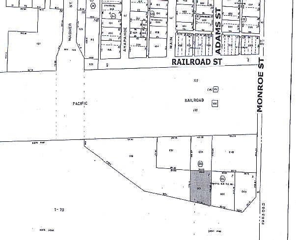
56773 Frontage Rd
Denver-Aurora-Lakewood, CO
Crandall Sub 1St Flg
1983-04-1-05-001
SUBDIVISIONCD 018037 SUBDIVISIONNAME CRANDALL SUB 1ST FLG BLOCK 000 LOT 001 LOT 1 CRANDALL SUB 1ST FLG
Autorepair
Arapahoe
X
Colorado
08005C0300K
001,1
2023
0.62 AC
2024
Southeast Outlying
007101
Denver
4,050 SF
DEMOGRAPHICS near 56773 Frontage Rd
1 Mile
3 Mile
5 Mile
2024 Total Population
1,974
4,756
5,618
2029 Population
2,060
4,906
5,774
Pop Growth 2024-2029
+ 4.36%
+ 3.15%
+ 2.78%
Average Age
38
39
39
2024 Total Households
688
1,651
1,948
HH Growth 2024-2029
+ 4.36%
+ 3.21%
+ 2.82%
Median Household Inc
$96,022
$104,335
$104,180
Avg Household Size
2.80
2.80
2.80
2024 Avg HH Vehicles
3.00
3.00
3.00
Median Home Value
$454,999
$539,169
$562,840
Median Year Built
2003
2000
2000
Nearby Places
- Restaurants
- Banks
- Shops
- Fitness
- Groceries
PUBLIC TRANSPORTATION
AIRPORT
Denver International
DRIVE
WALK
Distance
Denver International
37 min
33.6 mi
Freight Ports
Tulsa Port Of Catoosa
DRIVE
WALK
Distance
Tulsa Port Of Catoosa
687 min
672.0 mi
Nearby Properties
Address
Land Use
TOTAL SIZE
Lot Size
Zoning
Address
Land Use
TOTAL SIZE
Lot Size
Zoning
134,202 SF
12.51 AC
R1C
Address
Land Use
TOTAL SIZE
Lot Size
Zoning
48,888 SF
10.40 AC
A2
Address
Land Use
TOTAL SIZE
Lot Size
Zoning
46,554 SF
3.35 AC
Address
Land Use
TOTAL SIZE
Lot Size
Zoning
2,392 SF
37.76 AC
A3
Address
Land Use
TOTAL SIZE
Lot Size
Zoning
24,443 SF
2.98 AC
Address
Land Use
TOTAL SIZE
Lot Size
Zoning
Address
Land Use
TOTAL SIZE
Lot Size
Zoning
9,100 SF
1.28 AC
A3
Address
Land Use
TOTAL SIZE
Lot Size
Zoning
28,370 SF
10.01 AC
A3
Address
Land Use
TOTAL SIZE
Lot Size
Zoning
12,792 SF
17.62 AC
A2
Address
Land Use
TOTAL SIZE
Lot Size
Zoning
6,545 SF
1.02 AC
C5
Address
Land Use
TOTAL SIZE
Lot Size
Zoning
8,906 SF
1.10 AC
PUD
Address
Land Use
TOTAL SIZE
Lot Size
Zoning
3,816 SF
6.70 AC
Address
Land Use
TOTAL SIZE
Lot Size
Zoning
4.66 AC
Address
Land Use
TOTAL SIZE
Lot Size
Zoning
7,320 SF
1.24 AC
C5
Address
Land Use
TOTAL SIZE
Lot Size
Zoning
11,932 SF
6.44 AC
A1
Address
Land Use
TOTAL SIZE
Lot Size
Zoning
5,292 SF
0.26 AC
C3
Address
Land Use
TOTAL SIZE
Lot Size
Zoning
4,410 SF
0.29 AC
C5
Address
Land Use
TOTAL SIZE
Lot Size
Zoning
30,666 SF
2.43 AC
PUD
Address
Land Use
TOTAL SIZE
Lot Size
Zoning
19,887 SF
28.56 AC
A3
Address
Land Use
TOTAL SIZE
Lot Size
Zoning
14,706 SF
3.10 AC
Address
Land Use
TOTAL SIZE
Lot Size
Zoning
7,746 SF
0.40 AC
Address
Land Use
TOTAL SIZE
Lot Size
Zoning
11,856 SF
1.57 AC
Address
Land Use
TOTAL SIZE
Lot Size
Zoning
7,648 SF
5 AC
Address
Land Use
TOTAL SIZE
Lot Size
Zoning
13,892 SF
0.39 AC
Address
Land Use
TOTAL SIZE
Lot Size
Zoning
4,042 SF
1.97 AC
Address
Land Use
TOTAL SIZE
Lot Size
Zoning
6,667 SF
0.34 AC
C3
Address
Land Use
TOTAL SIZE
Lot Size
Zoning
4,805 SF
1.54 AC
Address
Land Use
TOTAL SIZE
Lot Size
Zoning
6,880 SF
0.18 AC
C4
Address
Land Use
TOTAL SIZE
Lot Size
Zoning
10,074 SF
1.06 AC
C5
The World's #1 Commercial Real Estate Marketplace
Connect with us
© 2025 CoStar Group
The information above has been obtained from sources believed reliable. While we do not doubt its accuracy we have not verified it and make no guarantee, warranty or representation about it. It is your responsibility to independently confirm its accuracy and completeness. Any projections, opinions, assumptions, or estimates used are for example only and do not represent the current or future performance of the property. The value of this transaction to you depends on tax and other factors which should be evaluated by your tax, financial, and legal advisors. You and your advisors should conduct a careful, independent investigation of the property to determine to your satisfaction the suitability of the property for your needs.