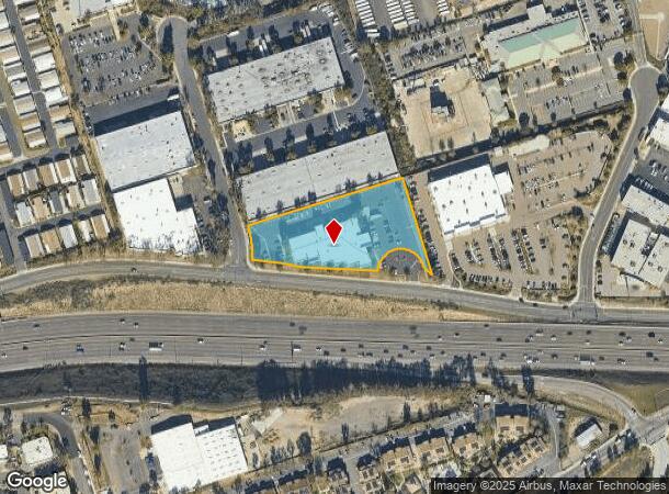
Property Record
570 Rancheros Dr, San Marcos, CA 92069

NEARBY LISTINGS FOR SALE OR LEASE
Property Detail
570 Rancheros Dr
San Diego-Carlsbad, CA
Rancho Los Vallecitos De San M
220-250-40
BLK 55 LOTS 8&9 ST CLSD ADJ&DOC89-126886 IN TR 000806
Storemultistory
San Diego
X
California
06073C0794G
8,9
2024
2.20 AC
2024
San Marcos
020023
San Diego
46,498 SF
DEMOGRAPHICS near 570 Rancheros Dr
1 Mile
3 Mile
5 Mile
2024 Total Population
12,851
85,818
221,315
2029 Population
12,689
85,335
219,219
Pop Growth 2024-2029
(1.26%)
(0.56%)
(0.95%)
Average Age
36
38
38
2024 Total Households
4,038
28,344
72,123
HH Growth 2024-2029
(1.41%)
(0.71%)
(1.08%)
Median Household Inc
$92,616
$94,143
$84,898
Avg Household Size
3.00
2.90
2.90
2024 Avg HH Vehicles
2.00
2.00
2.00
Median Home Value
$668,753
$700,065
$702,511
Median Year Built
1987
1988
1984
Nearby Places
- Restaurants
- Banks
- Shops
- Fitness
- Groceries
PUBLIC TRANSPORTATION
TRANSIT/SUBWAY
San Marcos Civic Center (Sprinter - San Diego North County Transit District (Coaster/Sprinter/Breeze))
DRIVE
WALK
Distance
San Marcos Civic Center (Sprinter - San Diego North County Transit District (Coaster/Sprinter/Breeze))
4 min
19 min
1.0 mi
AIRPORT
San Diego International
DRIVE
WALK
Distance
San Diego International
45 min
33.6 mi
Freight Ports
Port of San Diego
DRIVE
WALK
Distance
Port of San Diego
48 min
35.8 mi
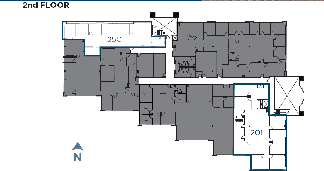
SALE & LEASE HISTORY
LISTING DATE
SALE/LEASE

May 15, 2023
For Lease
Aug 02, 2021
For Lease
Nearby Properties
Address
Land Use
TOTAL SIZE
Lot Size
Zoning
Address
Land Use
TOTAL SIZE
Lot Size
Zoning
27.98 AC
SPA
Address
Land Use
TOTAL SIZE
Lot Size
Zoning
9.77 AC
PD-R-18
Address
Land Use
TOTAL SIZE
Lot Size
Zoning
15.37 AC
SPA
Address
Land Use
TOTAL SIZE
Lot Size
Zoning
5.25 AC
SPA
Address
Land Use
TOTAL SIZE
Lot Size
Zoning
5.37 AC
SPA
Address
Land Use
TOTAL SIZE
Lot Size
Zoning
10.82 AC
SPA
Address
Land Use
TOTAL SIZE
Lot Size
Zoning
Address
Land Use
TOTAL SIZE
Lot Size
Zoning
16.91 AC
C
Address
Land Use
TOTAL SIZE
Lot Size
Zoning
9.88 AC
R-3-10
Address
Land Use
TOTAL SIZE
Lot Size
Zoning
Address
Land Use
TOTAL SIZE
Lot Size
Zoning
75,138 SF
C
Address
Land Use
TOTAL SIZE
Lot Size
Zoning
80,064 SF
1.53 AC
S-P
Address
Land Use
TOTAL SIZE
Lot Size
Zoning
99,461 SF
4.89 AC
SPA
Address
Land Use
TOTAL SIZE
Lot Size
Zoning
10.80 AC
SPA
Address
Land Use
TOTAL SIZE
Lot Size
Zoning
1.94 AC
C
Address
Land Use
TOTAL SIZE
Lot Size
Zoning
9.99 AC
MU-1
Address
Land Use
TOTAL SIZE
Lot Size
Zoning
59,858 SF
12.12 AC
A70
Address
Land Use
TOTAL SIZE
Lot Size
Zoning
1.49 AC
SPA
Address
Land Use
TOTAL SIZE
Lot Size
Zoning
7.06 AC
SR
Address
Land Use
TOTAL SIZE
Lot Size
Zoning
5.85 AC
SPA
Address
Land Use
TOTAL SIZE
Lot Size
Zoning
95,713 SF
0.51 AC
C
Address
Land Use
TOTAL SIZE
Lot Size
Zoning
10.69 AC
R-3-10
Address
Land Use
TOTAL SIZE
Lot Size
Zoning
16.12 AC
SPA
Address
Land Use
TOTAL SIZE
Lot Size
Zoning
10.83 AC
SPA
Address
Land Use
TOTAL SIZE
Lot Size
Zoning
96,747 SF
3.34 AC
SPA
Address
Land Use
TOTAL SIZE
Lot Size
Zoning
91,354 SF
2.66 AC
SPA
Address
Land Use
TOTAL SIZE
Lot Size
Zoning
99,500 SF
4.57 AC
SPA
Address
Land Use
TOTAL SIZE
Lot Size
Zoning
10 AC
MU-3
Address
Land Use
TOTAL SIZE
Lot Size
Zoning
6.16 AC
SPA
Address
Land Use
TOTAL SIZE
Lot Size
Zoning
14.12 AC
C
The World's #1 Commercial Real Estate Marketplace
Connect with us
© 2025 CoStar Group
The information above has been obtained from sources believed reliable. While we do not doubt its accuracy we have not verified it and make no guarantee, warranty or representation about it. It is your responsibility to independently confirm its accuracy and completeness. Any projections, opinions, assumptions, or estimates used are for example only and do not represent the current or future performance of the property. The value of this transaction to you depends on tax and other factors which should be evaluated by your tax, financial, and legal advisors. You and your advisors should conduct a careful, independent investigation of the property to determine to your satisfaction the suitability of the property for your needs.