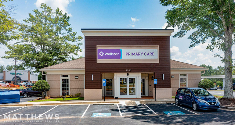
Property Record
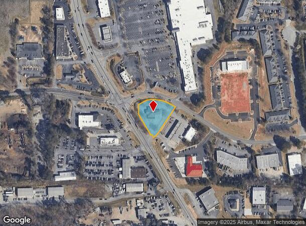
5705 Atlanta Hwy, Alpharetta, GA 30004
This Property Is For Sale
NEARBY LISTINGS FOR SALE OR LEASE
Property Detail
5705 Atlanta Hwy
Atlanta-Sandy Springs-Roswell, GA
Grassland Bus Park
018-099
2-1 610-611 TRACT 2A
Financialbuilding
Forsyth
X
Georgia
13121C0019G
611
2023
0.82 AC
2024
N Fulton/Forsyth County
130601
Atlanta
2,610 SF
DEMOGRAPHICS near 5705 Atlanta Hwy
1 Mile
3 Mile
5 Mile
2024 Total Population
3,708
46,802
121,823
2029 Population
4,170
52,356
134,643
Pop Growth 2024-2029
+ 12.46%
+ 11.87%
+ 10.52%
Average Age
36
37
38
2024 Total Households
1,223
16,217
41,956
HH Growth 2024-2029
+ 12.84%
+ 11.69%
+ 10.39%
Median Household Inc
$114,696
$126,377
$135,765
Avg Household Size
3.00
2.80
2.90
2024 Avg HH Vehicles
2.00
2.00
2.00
Median Home Value
$623,514
$465,603
$492,035
Median Year Built
2005
2004
2002
Nearby Places
- Restaurants
- Banks
- Shops
- Fitness
- Groceries
Nearby Properties
Address
Land Use
TOTAL SIZE
Lot Size
Zoning
Address
Land Use
TOTAL SIZE
Lot Size
Zoning
574,271 SF
45.82 AC
AC
Address
Land Use
TOTAL SIZE
Lot Size
Zoning
461,754 SF
28.07 AC
C1C
Address
Land Use
TOTAL SIZE
Lot Size
Zoning
328,265 SF
4 AC
MP
Address
Land Use
TOTAL SIZE
Lot Size
Zoning
440,698 SF
25.68 AC
R4
Address
Land Use
TOTAL SIZE
Lot Size
Zoning
309,293 SF
16 AC
CBD
Address
Land Use
TOTAL SIZE
Lot Size
Zoning
383,859 SF
9.05 AC
CBD
Address
Land Use
TOTAL SIZE
Lot Size
Zoning
56,313 SF
13.37 AC
MP
Address
Land Use
TOTAL SIZE
Lot Size
Zoning
2.12 AC
MP
Address
Land Use
TOTAL SIZE
Lot Size
Zoning
90,671 SF
11.03 AC
MP
Address
Land Use
TOTAL SIZE
Lot Size
Zoning
10,908 SF
107.57 AC
RES3
Address
Land Use
TOTAL SIZE
Lot Size
Zoning
373,746 SF
19.89 AC
TRCON
Address
Land Use
TOTAL SIZE
Lot Size
Zoning
186,907 SF
13.93 AC
A0
Address
Land Use
TOTAL SIZE
Lot Size
Zoning
119,926 SF
23.23 AC
M1
Address
Land Use
TOTAL SIZE
Lot Size
Zoning
64.48 AC
AG1
Address
Land Use
TOTAL SIZE
Lot Size
Zoning
83,161 SF
277.43 AC
A1
Address
Land Use
TOTAL SIZE
Lot Size
Zoning
232,832 SF
17.74 AC
M1
Address
Land Use
TOTAL SIZE
Lot Size
Zoning
116,640 SF
6.92 AC
MP
Address
Land Use
TOTAL SIZE
Lot Size
Zoning
122,964 SF
7.82 AC
RES6
Address
Land Use
TOTAL SIZE
Lot Size
Zoning
207,663 SF
60.62 AC
R2R
Address
Land Use
TOTAL SIZE
Lot Size
Zoning
130,155 SF
17.10 AC
M1
Address
Land Use
TOTAL SIZE
Lot Size
Zoning
136,122 SF
9.95 AC
M1
Address
Land Use
TOTAL SIZE
Lot Size
Zoning
95,950 SF
14 AC
M1
Address
Land Use
TOTAL SIZE
Lot Size
Zoning
6.07 AC
MP
Address
Land Use
TOTAL SIZE
Lot Size
Zoning
138,000 SF
14.07 AC
M1
Address
Land Use
TOTAL SIZE
Lot Size
Zoning
135,844 SF
33.91 AC
M1
Address
Land Use
TOTAL SIZE
Lot Size
Zoning
293,211 SF
16.18 AC
M1
Address
Land Use
TOTAL SIZE
Lot Size
Zoning
124,700 SF
9.67 AC
M1
Address
Land Use
TOTAL SIZE
Lot Size
Zoning
116,948 SF
8.68 AC
M1
Address
Land Use
TOTAL SIZE
Lot Size
Zoning
73,120 SF
1.22 AC
AG1
Address
Land Use
TOTAL SIZE
Lot Size
Zoning
6,298 SF
87.14 AC
A1
The World's #1 Commercial Real Estate Marketplace
Connect with us
© 2025 CoStar Group
The information above has been obtained from sources believed reliable. While we do not doubt its accuracy we have not verified it and make no guarantee, warranty or representation about it. It is your responsibility to independently confirm its accuracy and completeness. Any projections, opinions, assumptions, or estimates used are for example only and do not represent the current or future performance of the property. The value of this transaction to you depends on tax and other factors which should be evaluated by your tax, financial, and legal advisors. You and your advisors should conduct a careful, independent investigation of the property to determine to your satisfaction the suitability of the property for your needs.