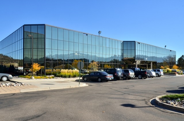
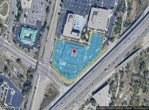
Property Record
5725 Mark Dabling Blvd, Colorado Springs, CO 80919


Current Lease Availabilities
NEARBY LISTINGS FOR SALE OR LEASE
Property Detail
5725 Mark Dabling Blvd
Colorado Springs, CO
North Creek Sub
63184-02-018
LOT 1 BLK 1 NORTH CREEK SUBDIVISION COLO SPGS, EX THAT PT CONV TO D O T BY REC #205127350
Officebuilding
El Paso
X
Colorado
08041C0512G
1
2023
5.43 AC
2024
Northwest
003705
Colorado Springs
110,795 SF
DEMOGRAPHICS near 5725 Mark Dabling Blvd
1 Mile
3 Mile
5 Mile
2024 Total Population
6,534
76,222
200,326
2029 Population
6,751
79,423
208,313
Pop Growth 2024-2029
+ 3.32%
+ 4.20%
+ 3.99%
Average Age
38
41
40
2024 Total Households
2,783
32,297
82,795
HH Growth 2024-2029
+ 3.49%
+ 4.41%
+ 4.22%
Median Household Inc
$70,545
$74,639
$76,865
Avg Household Size
2.30
2.30
2.30
2024 Avg HH Vehicles
2.00
2.00
2.00
Median Home Value
$416,499
$410,881
$403,689
Median Year Built
1984
1983
1981
Nearby Places
- Restaurants
- Banks
- Shops
- Fitness
- Groceries
PUBLIC TRANSPORTATION
AIRPORT
City of Colorado Springs Municipal
DRIVE
WALK
Distance
City of Colorado Springs Municipal
30 min
17.8 mi
Freight Ports
Tulsa Port Of Catoosa
DRIVE
WALK
Distance
Tulsa Port Of Catoosa
740 min
691.9 mi
Nearby Properties
Address
Land Use
TOTAL SIZE
Lot Size
Zoning
Address
Land Use
TOTAL SIZE
Lot Size
Zoning
662,208 SF
14.96 AC
PIP1
Address
Land Use
TOTAL SIZE
Lot Size
Zoning
99,488 SF
13.01 AC
PUD
Address
Land Use
TOTAL SIZE
Lot Size
Zoning
747,294 SF
61.26 AC
PIP1 HS
Address
Land Use
TOTAL SIZE
Lot Size
Zoning
62,201 SF
5.68 AC
OC
Address
Land Use
TOTAL SIZE
Lot Size
Zoning
409,164 SF
19.26 AC
PUD
Address
Land Use
TOTAL SIZE
Lot Size
Zoning
158,502 SF
5.73 AC
OC HS
Address
Land Use
TOTAL SIZE
Lot Size
Zoning
216,966 SF
30.11 AC
PUD UV P
Address
Land Use
TOTAL SIZE
Lot Size
Zoning
437,714 SF
24.97 AC
PIP2 PUD U
Address
Land Use
TOTAL SIZE
Lot Size
Zoning
136,062 SF
11.38 AC
C5 CU P
Address
Land Use
TOTAL SIZE
Lot Size
Zoning
296,778 SF
14.67 AC
PBC CU HS
Address
Land Use
TOTAL SIZE
Lot Size
Zoning
369,144 SF
11.19 AC
PBC CU HS
Address
Land Use
TOTAL SIZE
Lot Size
Zoning
106,190 SF
8 AC
PIP2 CU HS
Address
Land Use
TOTAL SIZE
Lot Size
Zoning
103,599 SF
7.86 AC
OC/CR
Address
Land Use
TOTAL SIZE
Lot Size
Zoning
98,482 SF
12.53 AC
PIP1/CR PI
Address
Land Use
TOTAL SIZE
Lot Size
Zoning
64,620 SF
4.32 AC
OC
Address
Land Use
TOTAL SIZE
Lot Size
Zoning
301,559 SF
46.67 AC
PIP1/CR CU
Address
Land Use
TOTAL SIZE
Lot Size
Zoning
154,749 SF
14.17 AC
PBC/CR
Address
Land Use
TOTAL SIZE
Lot Size
Zoning
236,600 SF
17.34 AC
PUD
Address
Land Use
TOTAL SIZE
Lot Size
Zoning
129,364 SF
7.13 AC
PIP1/CR
Address
Land Use
TOTAL SIZE
Lot Size
Zoning
150,075 SF
10.78 AC
PIP1 HS CU
Address
Land Use
TOTAL SIZE
Lot Size
Zoning
77,655 SF
8.39 AC
OC OC/CR H
Address
Land Use
TOTAL SIZE
Lot Size
Zoning
268,605 SF
12.81 AC
PBC CU SS
Address
Land Use
TOTAL SIZE
Lot Size
Zoning
199,901 SF
9.77 AC
PBC/CR HS
Address
Land Use
TOTAL SIZE
Lot Size
Zoning
554,579 SF
97.22 AC
PIP1
Address
Land Use
TOTAL SIZE
Lot Size
Zoning
184,424 SF
15.83 AC
PIP1
Address
Land Use
TOTAL SIZE
Lot Size
Zoning
80,802 SF
14.45 AC
PF NNA
Address
Land Use
TOTAL SIZE
Lot Size
Zoning
100,020 SF
3.87 AC
C6 C6/CR
Address
Land Use
TOTAL SIZE
Lot Size
Zoning
254,039 SF
13.47 AC
R5 CU
Address
Land Use
TOTAL SIZE
Lot Size
Zoning
89,592 SF
7.60 AC
R CU
Address
Land Use
TOTAL SIZE
Lot Size
Zoning
104,904 SF
5.99 AC
OC HS
The World's #1 Commercial Real Estate Marketplace
Connect with us
© 2025 CoStar Group
The information above has been obtained from sources believed reliable. While we do not doubt its accuracy we have not verified it and make no guarantee, warranty or representation about it. It is your responsibility to independently confirm its accuracy and completeness. Any projections, opinions, assumptions, or estimates used are for example only and do not represent the current or future performance of the property. The value of this transaction to you depends on tax and other factors which should be evaluated by your tax, financial, and legal advisors. You and your advisors should conduct a careful, independent investigation of the property to determine to your satisfaction the suitability of the property for your needs.