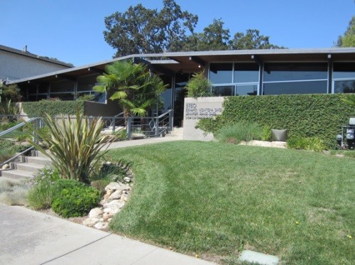
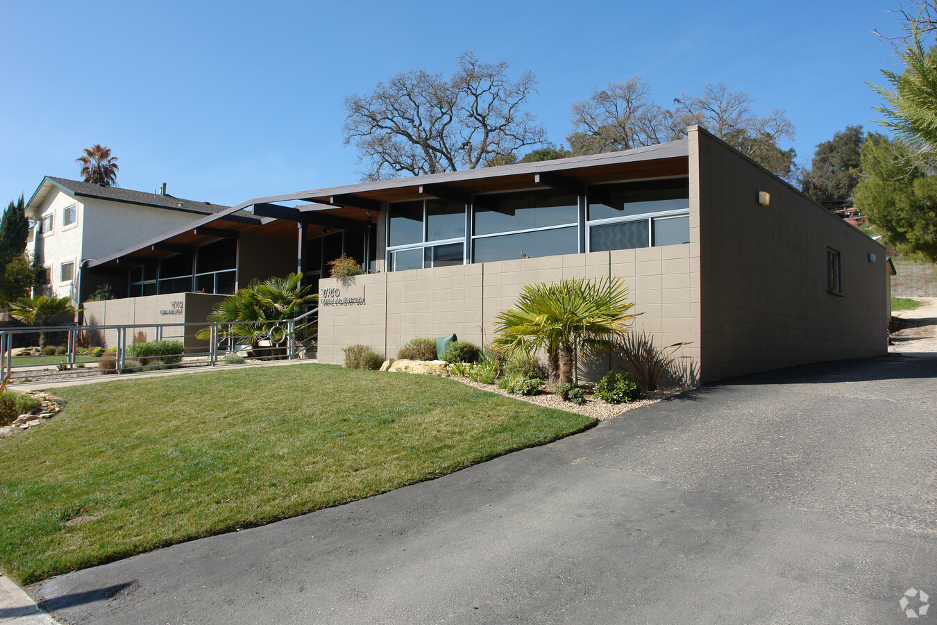
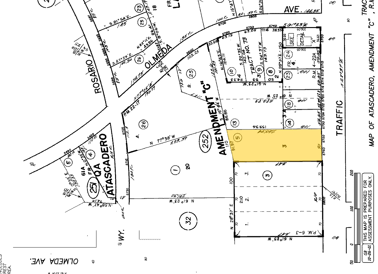
Property Record
5750 Traffic Way, Atascadero, CA 93422
NEARBY LISTINGS FOR SALE OR LEASE
Property Detail
5750 Traffic Way
San Luis Obispo-Paso Robles-Arroyo Grande, CA
Atascadero
029-252-005
San Luis Obispo
Miscresidentialimprovement
California
X
0.54 AC
06079C0831G
North 101 Corridor
740 SF
San Luis Obispo/Paso Robles
DEMOGRAPHICS near 5750 Traffic Way
1 Mile
3 Mile
5 Mile
2024 Total Population
7,691
24,662
34,726
2029 Population
7,571
24,238
34,117
Pop Growth 2024-2029
(1.56%)
(1.72%)
(1.75%)
Average Age
40
42
42
2024 Total Households
2,979
9,539
13,309
HH Growth 2024-2029
(1.75%)
(1.91%)
(1.96%)
Median Household Inc
$85,627
$85,506
$89,593
Avg Household Size
2.50
2.50
2.50
2024 Avg HH Vehicles
2.00
2.00
2.00
Median Home Value
$576,867
$640,738
$672,578
Median Year Built
1974
1978
1981
Nearby Places
- Restaurants
- Banks
- Shops
- Fitness
- Groceries
PUBLIC TRANSPORTATION
AIRPORT
San Luis County Regional
DRIVE
WALK
Distance
San Luis County Regional
33 min
23.4 mi
Freight Ports
The Port of Hueneme
DRIVE
WALK
Distance
The Port of Hueneme
190 min
150.5 mi
SALE & LEASE HISTORY
LISTING DATE
SALE/LEASE

Sep 20, 2021
For Lease
May 22, 2018
For Lease
May 09, 2018
For Lease
Nearby Properties
Address
Land Use
TOTAL SIZE
Lot Size
Zoning
Address
Land Use
TOTAL SIZE
Lot Size
Zoning
1.78 AC
CPK
Address
Land Use
TOTAL SIZE
Lot Size
Zoning
57,534 SF
6.10 AC
CR
Address
Land Use
TOTAL SIZE
Lot Size
Zoning
89,617 SF
6.97 AC
CPK
Address
Land Use
TOTAL SIZE
Lot Size
Zoning
68,381 SF
3.40 AC
MF20
Address
Land Use
TOTAL SIZE
Lot Size
Zoning
12 AC
CPK
Address
Land Use
TOTAL SIZE
Lot Size
Zoning
18,800 SF
0.45 AC
DC
Address
Land Use
TOTAL SIZE
Lot Size
Zoning
49,652 SF
3.84 AC
CR
Address
Land Use
TOTAL SIZE
Lot Size
Zoning
39,765 SF
2.43 AC
CR
Address
Land Use
TOTAL SIZE
Lot Size
Zoning
14,932 SF
0.64 AC
DC
Address
Land Use
TOTAL SIZE
Lot Size
Zoning
7,114 SF
32.04 AC
AG
Address
Land Use
TOTAL SIZE
Lot Size
Zoning
1,468 SF
3.72 AC
MF20
Address
Land Use
TOTAL SIZE
Lot Size
Zoning
2.94 AC
CR
Address
Land Use
TOTAL SIZE
Lot Size
Zoning
42,993 SF
1.72 AC
CR
Address
Land Use
TOTAL SIZE
Lot Size
Zoning
5.02 AC
MF20
Address
Land Use
TOTAL SIZE
Lot Size
Zoning
34,661 SF
1.57 AC
MF20
Address
Land Use
TOTAL SIZE
Lot Size
Zoning
82,131 SF
2.95 AC
MF20
Address
Land Use
TOTAL SIZE
Lot Size
Zoning
Address
Land Use
TOTAL SIZE
Lot Size
Zoning
30,992 SF
2.05 AC
CT
Address
Land Use
TOTAL SIZE
Lot Size
Zoning
15.05 AC
RSFY
Address
Land Use
TOTAL SIZE
Lot Size
Zoning
0.91 AC
CP
Address
Land Use
TOTAL SIZE
Lot Size
Zoning
59,321 SF
3.92 AC
P
Address
Land Use
TOTAL SIZE
Lot Size
Zoning
18,000 SF
0.91 AC
CT
Address
Land Use
TOTAL SIZE
Lot Size
Zoning
2.33 AC
CR
Address
Land Use
TOTAL SIZE
Lot Size
Zoning
1.64 AC
CR
Address
Land Use
TOTAL SIZE
Lot Size
Zoning
69,680 SF
5.69 AC
CR
Address
Land Use
TOTAL SIZE
Lot Size
Zoning
17,161 SF
1.38 AC
CP
Address
Land Use
TOTAL SIZE
Lot Size
Zoning
30,829 SF
3.27 AC
CR
Address
Land Use
TOTAL SIZE
Lot Size
Zoning
3.21 AC
CR
Address
Land Use
TOTAL SIZE
Lot Size
Zoning
12,647 SF
0.98 AC
MF20
Address
Land Use
TOTAL SIZE
Lot Size
Zoning
2.12 AC
CR
The World's #1 Commercial Real Estate Marketplace
Connect with us
© 2025 CoStar Group
The information above has been obtained from sources believed reliable. While we do not doubt its accuracy we have not verified it and make no guarantee, warranty or representation about it. It is your responsibility to independently confirm its accuracy and completeness. Any projections, opinions, assumptions, or estimates used are for example only and do not represent the current or future performance of the property. The value of this transaction to you depends on tax and other factors which should be evaluated by your tax, financial, and legal advisors. You and your advisors should conduct a careful, independent investigation of the property to determine to your satisfaction the suitability of the property for your needs.