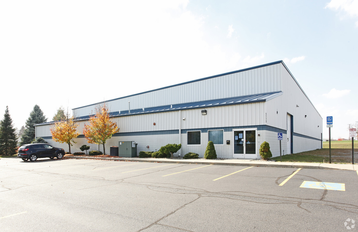
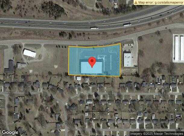
Property Record
5775 Ann Arbor Rd, Jackson, MI 49201

NEARBY LISTINGS FOR SALE OR LEASE
Property Detail
5775 Ann Arbor Rd
000-09-28-202-002-00
BEG AT THE N 1/4 POST OF SEC 28 TH S 481 FT TH S89?12'E 500 FT TO POB.TH N0?37'E 313.06 FT TO THE C L OF ANN ARBOR RD TH ELY ON THE ARC OF THE C L OF SD ANN ARBOR RD CHORD BEARING N87?57'E 418.07 FT TH N76?41'E 85.05 FT ALG THE C L OF ANN ARBOR RD TH
Officebuilding
Jackson
X
Michigan
26075C0215D
3.75 AC
2023
Jackson County
2024
West Michigan
006001
Jackson, MI
24,200 SF
DEMOGRAPHICS near 5775 Ann Arbor Rd
1 Mile
3 Mile
5 Mile
2024 Total Population
1,922
8,005
28,816
2029 Population
1,903
7,922
28,562
Pop Growth 2024-2029
(0.99%)
(1.04%)
(0.88%)
Average Age
42
42
40
2024 Total Households
743
3,222
11,730
HH Growth 2024-2029
(1.08%)
(1.15%)
(0.94%)
Median Household Inc
$52,348
$55,681
$49,086
Avg Household Size
2.40
2.40
2.30
2024 Avg HH Vehicles
2.00
2.00
2.00
Median Home Value
$167,898
$157,271
$118,480
Median Year Built
1974
1964
1956
Nearby Places
- Restaurants
- Banks
- Shops
- Fitness
- Groceries
PUBLIC TRANSPORTATION
COMMUTER RAIL
Jackson (Wolverine - Amtrak)
DRIVE
WALK
Distance
Jackson (Wolverine - Amtrak)
8 min
5.0 mi
Freight Ports
Port of Toledo
DRIVE
WALK
Distance
Port of Toledo
105 min
80.2 mi
Nearby Properties
Address
Land Use
TOTAL SIZE
Lot Size
Zoning
Address
Land Use
TOTAL SIZE
Lot Size
Zoning
186,754 SF
16.63 AC
R-4 HI
Address
Land Use
TOTAL SIZE
Lot Size
Zoning
289,727 SF
145.86 AC
B-4 GEN
Address
Land Use
TOTAL SIZE
Lot Size
Zoning
223,693 SF
27.35 AC
B-4 GEN
Address
Land Use
TOTAL SIZE
Lot Size
Zoning
62,227 SF
6.89 AC
R-1 ONE
Address
Land Use
TOTAL SIZE
Lot Size
Zoning
154,448 SF
12.97 AC
PR-1
Address
Land Use
TOTAL SIZE
Lot Size
Zoning
55,209 SF
5.67 AC
C-2
Address
Land Use
TOTAL SIZE
Lot Size
Zoning
168,392 SF
69.79 AC
AG AGRI
Address
Land Use
TOTAL SIZE
Lot Size
Zoning
54,464 SF
10.03 AC
ML LIGH
Address
Land Use
TOTAL SIZE
Lot Size
Zoning
67,289 SF
3.90 AC
C-1
Address
Land Use
TOTAL SIZE
Lot Size
Zoning
17.22 AC
C-3
Address
Land Use
TOTAL SIZE
Lot Size
Zoning
115,559 SF
14.01 AC
M HEAVY
Address
Land Use
TOTAL SIZE
Lot Size
Zoning
83,552 SF
25.50 AC
O-1
Address
Land Use
TOTAL SIZE
Lot Size
Zoning
32,127 SF
5.67 AC
C-2
Address
Land Use
TOTAL SIZE
Lot Size
Zoning
32.84 AC
RS SUBU
Address
Land Use
TOTAL SIZE
Lot Size
Zoning
10,891 SF
10.10 AC
C-1
Address
Land Use
TOTAL SIZE
Lot Size
Zoning
15,164 SF
2.10 AC
B-4 GEN
Address
Land Use
TOTAL SIZE
Lot Size
Zoning
52,500 SF
M HEAVY
Address
Land Use
TOTAL SIZE
Lot Size
Zoning
31,125 SF
4.89 AC
M HEAVY
Address
Land Use
TOTAL SIZE
Lot Size
Zoning
20 AC
AG-1
Address
Land Use
TOTAL SIZE
Lot Size
Zoning
4,947 SF
1.30 AC
C-2
Address
Land Use
TOTAL SIZE
Lot Size
Zoning
3,900 SF
172.98 AC
OS
Address
Land Use
TOTAL SIZE
Lot Size
Zoning
31,830 SF
3.23 AC
B-4 GEN
Address
Land Use
TOTAL SIZE
Lot Size
Zoning
24,936 SF
2.48 AC
B-4 GEN
Address
Land Use
TOTAL SIZE
Lot Size
Zoning
15,120 SF
2.50 AC
C-2
Address
Land Use
TOTAL SIZE
Lot Size
Zoning
23,430 SF
7.98 AC
M HEAVY
Address
Land Use
TOTAL SIZE
Lot Size
Zoning
4,896 SF
8.66 AC
B-4 GEN
Address
Land Use
TOTAL SIZE
Lot Size
Zoning
32,860 SF
1.34 AC
ML LIGH
Address
Land Use
TOTAL SIZE
Lot Size
Zoning
23,799 SF
5.67 AC
C-2
Address
Land Use
TOTAL SIZE
Lot Size
Zoning
43,197 SF
3.40 AC
B-2 COM
The World's #1 Commercial Real Estate Marketplace
Connect with us
© 2025 CoStar Group
The information above has been obtained from sources believed reliable. While we do not doubt its accuracy we have not verified it and make no guarantee, warranty or representation about it. It is your responsibility to independently confirm its accuracy and completeness. Any projections, opinions, assumptions, or estimates used are for example only and do not represent the current or future performance of the property. The value of this transaction to you depends on tax and other factors which should be evaluated by your tax, financial, and legal advisors. You and your advisors should conduct a careful, independent investigation of the property to determine to your satisfaction the suitability of the property for your needs.