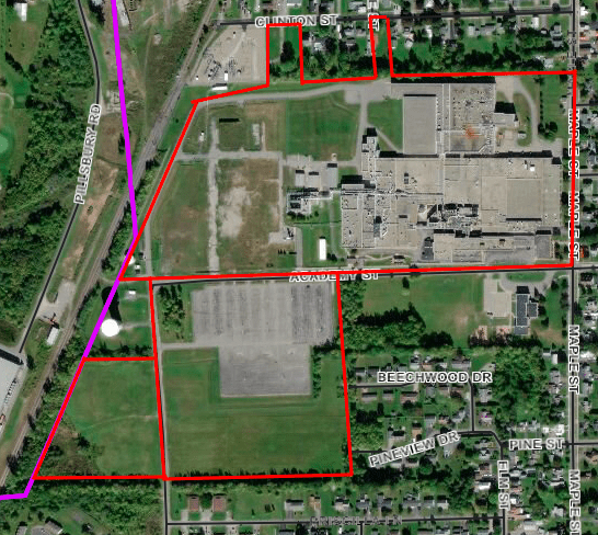
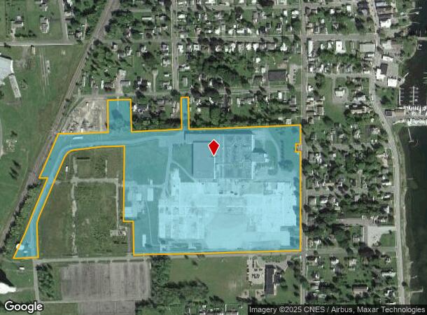
Property Record
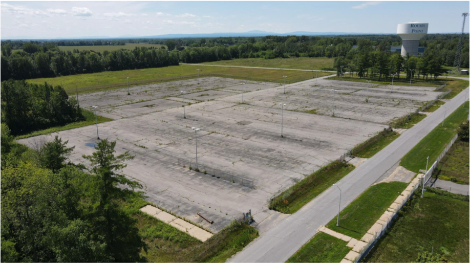
58 Maple St, Rouses Point, NY 12979

NEARBY LISTINGS FOR SALE OR LEASE
-
-
View all Rouses Point listings for lease on LoopNet.com
Property Detail
58 Maple St
092803-020-014-0001-003-003-0000
Clinton
Industrialgeneral
New York
X
3.003
36019C0301E
36 AC
2023
Upstate New York Area
2023
Other Market Areas
100102
Plattsburgh, NY
DEMOGRAPHICS near 58 Maple St
1 Mile
3 Mile
5 Mile
2024 Total Population
2,247
2,864
5,663
2029 Population
2,242
2,857
5,652
Pop Growth 2024-2029
(0.22%)
(0.24%)
(0.19%)
Average Age
46
45
44
2024 Total Households
1,088
1,355
2,542
HH Growth 2024-2029
(0.37%)
(0.30%)
(0.31%)
Median Household Inc
$40,089
$44,188
$52,081
Avg Household Size
2.10
2.10
2.20
2024 Avg HH Vehicles
1.00
1.00
2.00
Median Home Value
$138,488
$144,214
$150,621
Median Year Built
1965
1967
1968
Nearby Places
- Restaurants
- Banks
- Shops
- Fitness
- Groceries
PUBLIC TRANSPORTATION
COMMUTER RAIL
Rouses Point Amtrak (Adirondack - Amtrak)
DRIVE
WALK
Distance
Rouses Point Amtrak (Adirondack - Amtrak)
6 min
1.8 mi
AIRPORT
Plattsburgh International
DRIVE
WALK
Distance
Plattsburgh International
40 min
29.1 mi
Freight Ports
Montreal
DRIVE
WALK
Distance
Montreal
70 min
49.5 mi
SALE & LEASE HISTORY
LISTING DATE
SALE/LEASE

Mar 22, 2019
For Lease
Jun 12, 2019
For Lease
Feb 06, 2019
For Lease
Nearby Properties
Address
Land Use
TOTAL SIZE
Lot Size
Zoning
Address
Land Use
TOTAL SIZE
Lot Size
Zoning
174,431 SF
77.40 AC
Address
Land Use
TOTAL SIZE
Lot Size
Zoning
28,764 SF
22.60 AC
01 - NOT Z
Address
Land Use
TOTAL SIZE
Lot Size
Zoning
91,440 SF
9.80 AC
Address
Land Use
TOTAL SIZE
Lot Size
Zoning
Address
Land Use
TOTAL SIZE
Lot Size
Zoning
0.51 AC
Address
Land Use
TOTAL SIZE
Lot Size
Zoning
100,000 SF
9.54 AC
Address
Land Use
TOTAL SIZE
Lot Size
Zoning
29,085 SF
17.60 AC
Address
Land Use
TOTAL SIZE
Lot Size
Zoning
2.94 AC
Address
Land Use
TOTAL SIZE
Lot Size
Zoning
134,400 SF
11.60 AC
Address
Land Use
TOTAL SIZE
Lot Size
Zoning
380.60 AC
Address
Land Use
TOTAL SIZE
Lot Size
Zoning
64,000 SF
3.17 AC
01 - NOT Z
Address
Land Use
TOTAL SIZE
Lot Size
Zoning
50,000 SF
11.42 AC
Address
Land Use
TOTAL SIZE
Lot Size
Zoning
40,000 SF
3.35 AC
Address
Land Use
TOTAL SIZE
Lot Size
Zoning
15,000 SF
1.60 AC
Address
Land Use
TOTAL SIZE
Lot Size
Zoning
5,400 SF
9.17 AC
Address
Land Use
TOTAL SIZE
Lot Size
Zoning
55,625 SF
3.20 AC
01 - NOT Z
Address
Land Use
TOTAL SIZE
Lot Size
Zoning
19,747 SF
6.20 AC
Address
Land Use
TOTAL SIZE
Lot Size
Zoning
20,346 SF
9.70 AC
Address
Land Use
TOTAL SIZE
Lot Size
Zoning
40,000 SF
6.09 AC
Address
Land Use
TOTAL SIZE
Lot Size
Zoning
1,800 SF
66.50 AC
Address
Land Use
TOTAL SIZE
Lot Size
Zoning
3,158 SF
14 AC
Address
Land Use
TOTAL SIZE
Lot Size
Zoning
21,868 SF
32.21 AC
Address
Land Use
TOTAL SIZE
Lot Size
Zoning
7,584 SF
4.40 AC
Address
Land Use
TOTAL SIZE
Lot Size
Zoning
197 AC
Address
Land Use
TOTAL SIZE
Lot Size
Zoning
36,204 SF
7.26 AC
01 - NOT Z
Address
Land Use
TOTAL SIZE
Lot Size
Zoning
2,880 SF
26.50 AC
Address
Land Use
TOTAL SIZE
Lot Size
Zoning
10,000 SF
2.78 AC
Address
Land Use
TOTAL SIZE
Lot Size
Zoning
7,424 SF
0.81 AC
Address
Land Use
TOTAL SIZE
Lot Size
Zoning
0.91 AC
The World's #1 Commercial Real Estate Marketplace
Connect with us
© 2025 CoStar Group
The information above has been obtained from sources believed reliable. While we do not doubt its accuracy we have not verified it and make no guarantee, warranty or representation about it. It is your responsibility to independently confirm its accuracy and completeness. Any projections, opinions, assumptions, or estimates used are for example only and do not represent the current or future performance of the property. The value of this transaction to you depends on tax and other factors which should be evaluated by your tax, financial, and legal advisors. You and your advisors should conduct a careful, independent investigation of the property to determine to your satisfaction the suitability of the property for your needs.