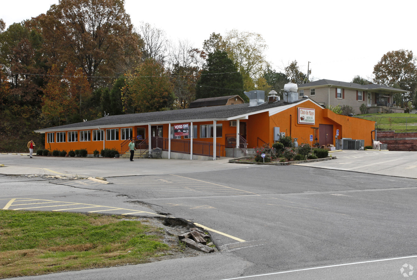
Property Record
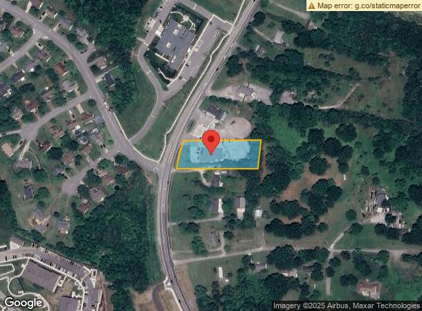
580 Nonaville Rd, Mount Juliet, TN 37122
NEARBY LISTINGS FOR SALE OR LEASE
Property Detail
580 Nonaville Rd
Nashville-Davidson--Murfreesboro--Franklin, TN
Cecil Gass Prop
050-109.01
PB 19 PG 863 LOT 2 CINCO DEMAYO
Commercialnec
Wilson
X
Tennessee
47037C0300J
2
2024
1 AC
2024
Mt Juliet-Lebanon
030304
Nashville
4,932 SF
DEMOGRAPHICS near 580 Nonaville Rd
1 Mile
3 Mile
5 Mile
2024 Total Population
3,660
32,072
74,115
2029 Population
4,326
37,581
83,860
Pop Growth 2024-2029
+ 18.20%
+ 17.18%
+ 13.15%
Average Age
40
40
40
2024 Total Households
1,321
11,265
26,806
HH Growth 2024-2029
+ 18.02%
+ 16.99%
+ 12.56%
Median Household Inc
$86,178
$103,218
$98,039
Avg Household Size
2.70
2.80
2.70
2024 Avg HH Vehicles
2.00
2.00
2.00
Median Home Value
$297,930
$355,550
$359,304
Median Year Built
1996
1993
1992
Nearby Places
- Restaurants
- Banks
- Shops
- Fitness
- Groceries
PUBLIC TRANSPORTATION
COMMUTER RAIL
Mt Juliet (East Corridor Line - Tennessee Regional Transportation Authority Music City Star (Music City Star))
DRIVE
WALK
Distance
Mt Juliet (East Corridor Line - Tennessee Regional Transportation Authority Music City Star (Music City Star))
8 min
4.0 mi
Hermitage (East Corridor Line - Tennessee Regional Transportation Authority Music City Star (Music City Star))
DRIVE
WALK
Distance
Hermitage (East Corridor Line - Tennessee Regional Transportation Authority Music City Star (Music City Star))
13 min
7.1 mi
AIRPORT
Nashville International
DRIVE
WALK
Distance
Nashville International
22 min
14.3 mi
Freight Ports
Port of Mobile
DRIVE
WALK
Distance
Port of Mobile
506 min
461.1 mi
Nearby Properties
Address
Land Use
TOTAL SIZE
Lot Size
Zoning
Address
Land Use
TOTAL SIZE
Lot Size
Zoning
375,981 SF
24.70 AC
Address
Land Use
TOTAL SIZE
Lot Size
Zoning
296,500 SF
4.42 AC
Address
Land Use
TOTAL SIZE
Lot Size
Zoning
65,428 SF
5.65 AC
PUD
Address
Land Use
TOTAL SIZE
Lot Size
Zoning
19,204 SF
9.23 AC
Address
Land Use
TOTAL SIZE
Lot Size
Zoning
91,365 SF
14.87 AC
CRC
Address
Land Use
TOTAL SIZE
Lot Size
Zoning
143,165 SF
144 AC
Address
Land Use
TOTAL SIZE
Lot Size
Zoning
15,125 SF
1 AC
Address
Land Use
TOTAL SIZE
Lot Size
Zoning
66,170 SF
11.30 AC
Address
Land Use
TOTAL SIZE
Lot Size
Zoning
Address
Land Use
TOTAL SIZE
Lot Size
Zoning
22,356 SF
4.13 AC
A
Address
Land Use
TOTAL SIZE
Lot Size
Zoning
40,704 SF
2.76 AC
CTC
Address
Land Use
TOTAL SIZE
Lot Size
Zoning
10,477 SF
1.74 AC
Address
Land Use
TOTAL SIZE
Lot Size
Zoning
36,040 SF
6.06 AC
Address
Land Use
TOTAL SIZE
Lot Size
Zoning
55,864 SF
3.18 AC
IG
Address
Land Use
TOTAL SIZE
Lot Size
Zoning
31,852 SF
5.10 AC
Address
Land Use
TOTAL SIZE
Lot Size
Zoning
32,430 SF
2.37 AC
Address
Land Use
TOTAL SIZE
Lot Size
Zoning
23,890 SF
2 AC
CTC
Address
Land Use
TOTAL SIZE
Lot Size
Zoning
720 SF
65.05 AC
Address
Land Use
TOTAL SIZE
Lot Size
Zoning
21,285 SF
2.02 AC
CTC
Address
Land Use
TOTAL SIZE
Lot Size
Zoning
30,641 SF
8.31 AC
Address
Land Use
TOTAL SIZE
Lot Size
Zoning
Address
Land Use
TOTAL SIZE
Lot Size
Zoning
15,166 SF
3.11 AC
CTC
Address
Land Use
TOTAL SIZE
Lot Size
Zoning
Address
Land Use
TOTAL SIZE
Lot Size
Zoning
14,100 SF
5 AC
Address
Land Use
TOTAL SIZE
Lot Size
Zoning
78,341 SF
8.30 AC
CG
Address
Land Use
TOTAL SIZE
Lot Size
Zoning
12,567 SF
3.30 AC
Address
Land Use
TOTAL SIZE
Lot Size
Zoning
29,378 SF
37.48 AC
R1
Address
Land Use
TOTAL SIZE
Lot Size
Zoning
12,933 SF
1.67 AC
Address
Land Use
TOTAL SIZE
Lot Size
Zoning
27,576 SF
2.40 AC
Address
Land Use
TOTAL SIZE
Lot Size
Zoning
16,940 SF
1.79 AC
CG
The World's #1 Commercial Real Estate Marketplace
Connect with us
© 2025 CoStar Group
The information above has been obtained from sources believed reliable. While we do not doubt its accuracy we have not verified it and make no guarantee, warranty or representation about it. It is your responsibility to independently confirm its accuracy and completeness. Any projections, opinions, assumptions, or estimates used are for example only and do not represent the current or future performance of the property. The value of this transaction to you depends on tax and other factors which should be evaluated by your tax, financial, and legal advisors. You and your advisors should conduct a careful, independent investigation of the property to determine to your satisfaction the suitability of the property for your needs.