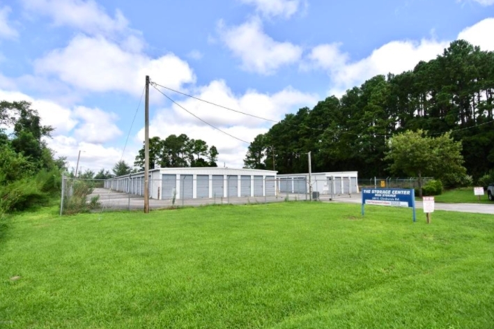
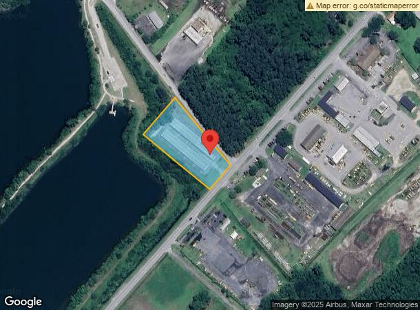
Property Record
580 S Glenburnie Rd, New Bern, NC 28560
NEARBY LISTINGS FOR SALE OR LEASE
Property Detail
580 S Glenburnie Rd
8-244-030
Harvey L Cox
Publicstorage
88 OAKS FARM
AE
Craven
3720557000K
North Carolina
2023
1.72 AC
2024
North Carolina Southeast Area
960502
Other Market Areas
10,400 SF
New Bern, NC
DEMOGRAPHICS near 580 S Glenburnie Rd
1 Mile
3 Mile
5 Mile
2024 Total Population
2,585
26,088
38,891
2029 Population
2,637
26,464
39,233
Pop Growth 2024-2029
+ 2.01%
+ 1.44%
+ 0.88%
Average Age
39
42
43
2024 Total Households
1,098
11,759
17,203
HH Growth 2024-2029
+ 1.82%
+ 1.41%
+ 0.89%
Median Household Inc
$37,645
$45,937
$53,607
Avg Household Size
2.30
2.10
2.20
2024 Avg HH Vehicles
2.00
2.00
2.00
Median Home Value
$146,391
$163,057
$188,566
Median Year Built
1985
1985
1986
Nearby Places
- Restaurants
- Banks
- Shops
- Fitness
- Groceries
PUBLIC TRANSPORTATION
AIRPORT
Coastal Carolina Regional
DRIVE
WALK
Distance
Coastal Carolina Regional
19 min
8.9 mi
Freight Ports
Port of Morehead City
DRIVE
WALK
Distance
Port of Morehead City
77 min
46.8 mi
SALE & LEASE HISTORY
LISTING DATE
SALE/LEASE

Aug 26, 2020
For Sale
Nearby Properties
Address
Land Use
TOTAL SIZE
Lot Size
Zoning
Address
Land Use
TOTAL SIZE
Lot Size
Zoning
26.16 AC
NC5
Address
Land Use
TOTAL SIZE
Lot Size
Zoning
280,000 SF
100.20 AC
NC5
Address
Land Use
TOTAL SIZE
Lot Size
Zoning
7,700 SF
9.49 AC
Address
Land Use
TOTAL SIZE
Lot Size
Zoning
55,296 SF
13.91 AC
NC3
Address
Land Use
TOTAL SIZE
Lot Size
Zoning
45,716 SF
7.60 AC
Address
Land Use
TOTAL SIZE
Lot Size
Zoning
11.63 AC
NC4
Address
Land Use
TOTAL SIZE
Lot Size
Zoning
24.65 AC
Address
Land Use
TOTAL SIZE
Lot Size
Zoning
23,376 SF
8.33 AC
NC3
Address
Land Use
TOTAL SIZE
Lot Size
Zoning
9,256 SF
12.16 AC
NC4
Address
Land Use
TOTAL SIZE
Lot Size
Zoning
54,250 SF
88.99 AC
NI1
Address
Land Use
TOTAL SIZE
Lot Size
Zoning
3,676 SF
14.63 AC
NC3
Address
Land Use
TOTAL SIZE
Lot Size
Zoning
103,440 SF
8.45 AC
NC3
Address
Land Use
TOTAL SIZE
Lot Size
Zoning
27,381 SF
8.69 AC
NC3
Address
Land Use
TOTAL SIZE
Lot Size
Zoning
48,950 SF
8.18 AC
NC4
Address
Land Use
TOTAL SIZE
Lot Size
Zoning
22,578 SF
14.34 AC
NC3
Address
Land Use
TOTAL SIZE
Lot Size
Zoning
8,052 SF
13.62 AC
NC3
Address
Land Use
TOTAL SIZE
Lot Size
Zoning
80,587 SF
2.85 AC
NC3
Address
Land Use
TOTAL SIZE
Lot Size
Zoning
135,083 SF
15.19 AC
NC3
Address
Land Use
TOTAL SIZE
Lot Size
Zoning
21,912 SF
5.67 AC
NC3
Address
Land Use
TOTAL SIZE
Lot Size
Zoning
113,816 SF
9.20 AC
NC3
Address
Land Use
TOTAL SIZE
Lot Size
Zoning
46,026 SF
9.32 AC
NC3
Address
Land Use
TOTAL SIZE
Lot Size
Zoning
47,604 SF
11.89 AC
NC3
Address
Land Use
TOTAL SIZE
Lot Size
Zoning
11,748 SF
7.28 AC
Address
Land Use
TOTAL SIZE
Lot Size
Zoning
37,979 SF
6.60 AC
NC3
Address
Land Use
TOTAL SIZE
Lot Size
Zoning
82,648 SF
11.34 AC
NC3
Address
Land Use
TOTAL SIZE
Lot Size
Zoning
Address
Land Use
TOTAL SIZE
Lot Size
Zoning
29,176 SF
5.82 AC
NC3
The World's #1 Commercial Real Estate Marketplace
Connect with us
© 2025 CoStar Group
The information above has been obtained from sources believed reliable. While we do not doubt its accuracy we have not verified it and make no guarantee, warranty or representation about it. It is your responsibility to independently confirm its accuracy and completeness. Any projections, opinions, assumptions, or estimates used are for example only and do not represent the current or future performance of the property. The value of this transaction to you depends on tax and other factors which should be evaluated by your tax, financial, and legal advisors. You and your advisors should conduct a careful, independent investigation of the property to determine to your satisfaction the suitability of the property for your needs.