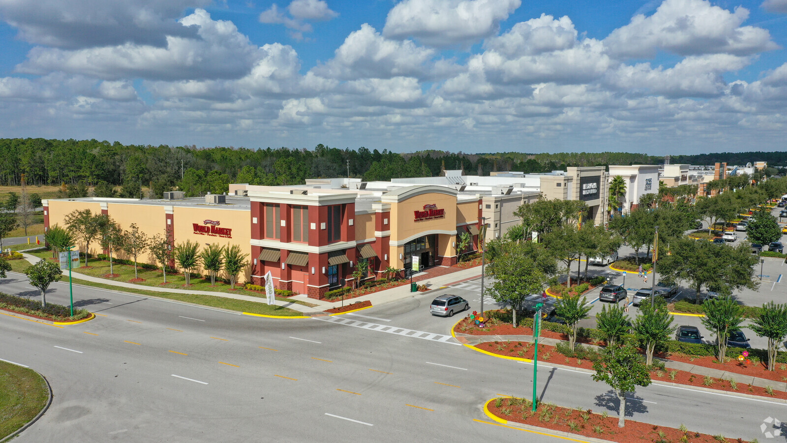
Property Record
5831 Wesley Grove Blvd, Wesley Chapel, FL 33544
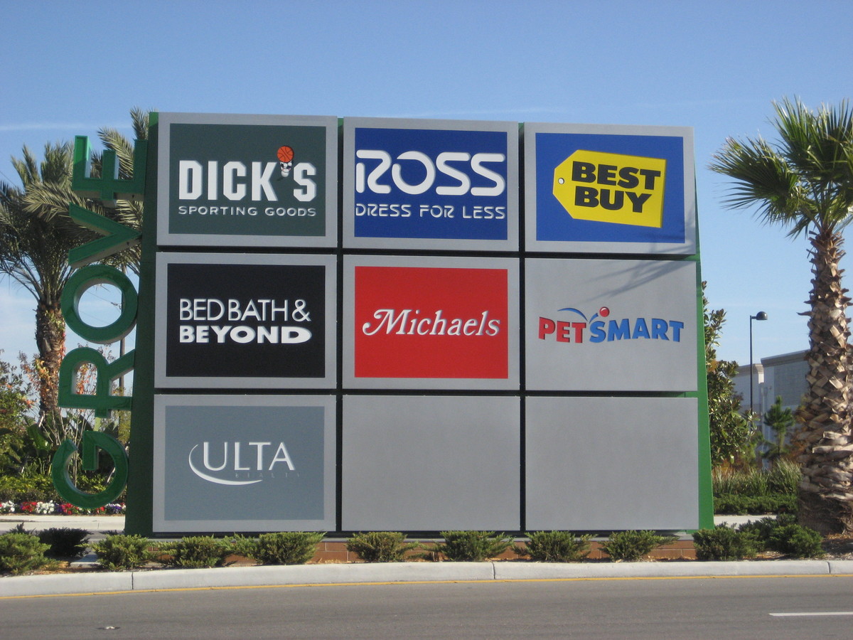

Current Lease Availabilities
NEARBY LISTINGS FOR SALE OR LEASE
Property Detail
5831 Wesley Grove Blvd
Tampa-St. Petersburg-Clearwater, FL
Shopping Center Or Other Site
12-26-19-0000-00100-0000
THAT POR OF FOLL LYING IN 06-26-20:COM AT SW COR OF SEC 6 TH N00DEG 1015E ALG W BDY 1295.64 FT TH N89DEG 4321E 216.47 FT TO PT ON ELY R/W LN OF OAKLEY BLVD FOR POB TH N00 DEG 1555E 20.00 FT TH N89DEG 4321E 1005.00 FT TH N00DEG 1555E 1100.15FT TH N89D
Regionalshoppingcenterormallwithanchorstore
Pasco
X
Florida
12101C0426F
3
2024
8.68 AC
2024
Pasco County
032006
Tampa/St Petersburg
99,666 SF
DEMOGRAPHICS near 5831 Wesley Grove Blvd
1 Mile
3 Mile
5 Mile
2024 Total Population
3,848
38,987
88,608
2029 Population
4,636
47,128
107,374
Pop Growth 2024-2029
+ 20.48%
+ 20.88%
+ 21.18%
Average Age
40
39
38
2024 Total Households
1,354
13,432
30,917
HH Growth 2024-2029
+ 20.38%
+ 20.85%
+ 21.07%
Median Household Inc
$83,212
$101,745
$101,350
Avg Household Size
2.80
2.80
2.80
2024 Avg HH Vehicles
2.00
2.00
2.00
Median Home Value
$268,181
$322,127
$310,213
Median Year Built
2001
2004
2005
Nearby Places
- Restaurants
- Banks
- Shops
- Fitness
- Groceries
PUBLIC TRANSPORTATION
AIRPORT
Tampa International
DRIVE
WALK
Distance
Tampa International
41 min
30.1 mi
Freight Ports
Port of Tampa Bay
DRIVE
WALK
Distance
Port of Tampa Bay
37 min
25.7 mi
Nearby Properties
Address
Land Use
TOTAL SIZE
Lot Size
Zoning
Address
Land Use
TOTAL SIZE
Lot Size
Zoning
435,775 SF
138.45 AC
AR
Address
Land Use
TOTAL SIZE
Lot Size
Zoning
306,559 SF
34.59 AC
MPUD
Address
Land Use
TOTAL SIZE
Lot Size
Zoning
343,155 SF
23.92 AC
MPUD
Address
Land Use
TOTAL SIZE
Lot Size
Zoning
315,343 SF
20.80 AC
MPUD
Address
Land Use
TOTAL SIZE
Lot Size
Zoning
418,644 SF
105.51 AC
AR
Address
Land Use
TOTAL SIZE
Lot Size
Zoning
319,575 SF
19.80 AC
MPUD
Address
Land Use
TOTAL SIZE
Lot Size
Zoning
244,355 SF
70.12 AC
MPUD
Address
Land Use
TOTAL SIZE
Lot Size
Zoning
267,326 SF
22.50 AC
MPUD
Address
Land Use
TOTAL SIZE
Lot Size
Zoning
153,412 SF
9.77 AC
MPUD
Address
Land Use
TOTAL SIZE
Lot Size
Zoning
146,401 SF
17.78 AC
MPUD
Address
Land Use
TOTAL SIZE
Lot Size
Zoning
115,596 SF
3.83 AC
C2
Address
Land Use
TOTAL SIZE
Lot Size
Zoning
189,610 SF
13.68 AC
MPUD
Address
Land Use
TOTAL SIZE
Lot Size
Zoning
86,782 SF
12.21 AC
C2
Address
Land Use
TOTAL SIZE
Lot Size
Zoning
28,631 SF
8.84 AC
MPUD
Address
Land Use
TOTAL SIZE
Lot Size
Zoning
106,061 SF
14.01 AC
MPUD
Address
Land Use
TOTAL SIZE
Lot Size
Zoning
118,112 SF
10.41 AC
MF1
Address
Land Use
TOTAL SIZE
Lot Size
Zoning
38,392 SF
9.54 AC
MPUD
Address
Land Use
TOTAL SIZE
Lot Size
Zoning
93,933 SF
3.63 AC
C2
Address
Land Use
TOTAL SIZE
Lot Size
Zoning
235,286 SF
15.11 AC
MF2
Address
Land Use
TOTAL SIZE
Lot Size
Zoning
210,354 SF
29.03 AC
C2
Address
Land Use
TOTAL SIZE
Lot Size
Zoning
118,441 SF
14.20 AC
C2
Address
Land Use
TOTAL SIZE
Lot Size
Zoning
91,050 SF
4.18 AC
C2
Address
Land Use
TOTAL SIZE
Lot Size
Zoning
153,903 SF
12.91 AC
I1
Address
Land Use
TOTAL SIZE
Lot Size
Zoning
16.81 AC
MPUD
Address
Land Use
TOTAL SIZE
Lot Size
Zoning
39,357 SF
8.44 AC
MPUD
Address
Land Use
TOTAL SIZE
Lot Size
Zoning
46,689 SF
10.06 AC
C2
Address
Land Use
TOTAL SIZE
Lot Size
Zoning
69,712 SF
10.27 AC
C2
Address
Land Use
TOTAL SIZE
Lot Size
Zoning
17,903 SF
43.42 AC
MPUD
Address
Land Use
TOTAL SIZE
Lot Size
Zoning
63,357 SF
2.98 AC
C2
The World's #1 Commercial Real Estate Marketplace
Connect with us
© 2025 CoStar Group
The information above has been obtained from sources believed reliable. While we do not doubt its accuracy we have not verified it and make no guarantee, warranty or representation about it. It is your responsibility to independently confirm its accuracy and completeness. Any projections, opinions, assumptions, or estimates used are for example only and do not represent the current or future performance of the property. The value of this transaction to you depends on tax and other factors which should be evaluated by your tax, financial, and legal advisors. You and your advisors should conduct a careful, independent investigation of the property to determine to your satisfaction the suitability of the property for your needs.