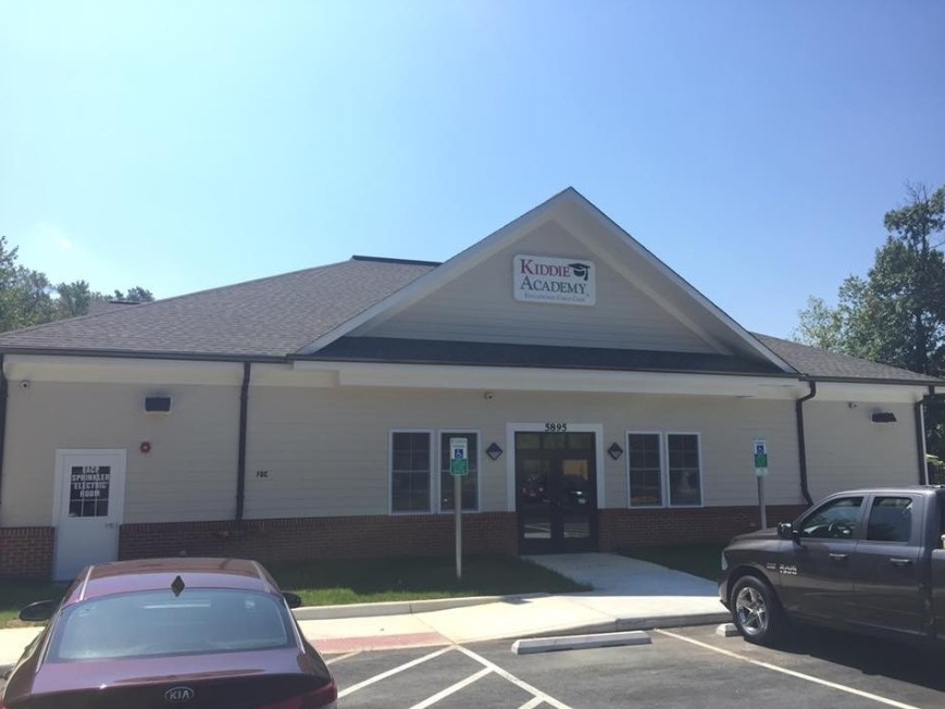
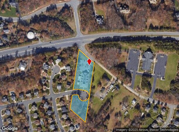
Property Record
5895 Websters Way, Manassas, VA 20112
NEARBY LISTINGS FOR SALE OR LEASE
Property Detail
5895 Websters Way
Washington-Arlington-Alexandria, DC-VA-MD-WV
Websters Landing
8093-10-7817
WEBSTERS LANDING L1A
Daycare
Prince William
X
Virginia
51059C0350E
1
2024
2.23 AC
2024
Woodbridge/I-95 Corridor
901226
Washington, DC
9,940 SF
DEMOGRAPHICS near 5895 Websters Way
1 Mile
3 Mile
5 Mile
2024 Total Population
9,653
65,557
157,608
2029 Population
9,862
67,107
161,200
Pop Growth 2024-2029
+ 2.17%
+ 2.36%
+ 2.28%
Average Age
37
38
38
2024 Total Households
2,691
19,352
48,738
HH Growth 2024-2029
+ 2.16%
+ 2.39%
+ 2.28%
Median Household Inc
$143,832
$137,504
$129,228
Avg Household Size
3.40
3.30
3.10
2024 Avg HH Vehicles
3.00
3.00
2.00
Median Home Value
$482,262
$460,111
$448,032
Median Year Built
1996
1988
1986
Nearby Places
- Restaurants
- Banks
- Shops
- Fitness
- Groceries
PUBLIC TRANSPORTATION
AIRPORT
Washington Dulles International
DRIVE
WALK
Distance
Washington Dulles International
48 min
27.7 mi
Ronald Reagan Washington Ntl
DRIVE
WALK
Distance
Ronald Reagan Washington Ntl
44 min
28.1 mi
Freight Ports
Port of Baltimore
DRIVE
WALK
Distance
Port of Baltimore
102 min
69.3 mi
Nearby Properties
Address
Land Use
TOTAL SIZE
Lot Size
Zoning
Address
Land Use
TOTAL SIZE
Lot Size
Zoning
202,395 SF
40.68 AC
A1
Address
Land Use
TOTAL SIZE
Lot Size
Zoning
40,578 SF
13.34 AC
PMD
Address
Land Use
TOTAL SIZE
Lot Size
Zoning
25,357 SF
15.96 AC
R16
Address
Land Use
TOTAL SIZE
Lot Size
Zoning
102,928 SF
17.06 AC
MIXED
Address
Land Use
TOTAL SIZE
Lot Size
Zoning
135,400 SF
42.13 AC
RPC
Address
Land Use
TOTAL SIZE
Lot Size
Zoning
212,338 SF
65.19 AC
A1
Address
Land Use
TOTAL SIZE
Lot Size
Zoning
139,698 SF
4.36 AC
PMD
Address
Land Use
TOTAL SIZE
Lot Size
Zoning
283,209 SF
72.49 AC
A1
Address
Land Use
TOTAL SIZE
Lot Size
Zoning
139,060 SF
14.75 AC
B1
Address
Land Use
TOTAL SIZE
Lot Size
Zoning
110,332 SF
19.47 AC
A1
Address
Land Use
TOTAL SIZE
Lot Size
Zoning
132,794 SF
29.46 AC
A1
Address
Land Use
TOTAL SIZE
Lot Size
Zoning
120,600 SF
6.25 AC
M2
Address
Land Use
TOTAL SIZE
Lot Size
Zoning
102,262 SF
11.74 AC
B2
Address
Land Use
TOTAL SIZE
Lot Size
Zoning
93,132 SF
2.71 AC
PMD
Address
Land Use
TOTAL SIZE
Lot Size
Zoning
97,560 SF
14.74 AC
MIXED
Address
Land Use
TOTAL SIZE
Lot Size
Zoning
86,477 SF
15.03 AC
A1
Address
Land Use
TOTAL SIZE
Lot Size
Zoning
299,000 SF
9.76 AC
PMR
Address
Land Use
TOTAL SIZE
Lot Size
Zoning
167,230 SF
27.55 AC
RPC
Address
Land Use
TOTAL SIZE
Lot Size
Zoning
80,706 SF
11.94 AC
A1
Address
Land Use
TOTAL SIZE
Lot Size
Zoning
130,339 SF
3.40 AC
RPC
Address
Land Use
TOTAL SIZE
Lot Size
Zoning
136,186 SF
2.97 AC
B1
Address
Land Use
TOTAL SIZE
Lot Size
Zoning
248,893 SF
11.45 AC
RPC
Address
Land Use
TOTAL SIZE
Lot Size
Zoning
98,867 SF
6.19 AC
R16
Address
Land Use
TOTAL SIZE
Lot Size
Zoning
69,696 SF
15 AC
RPC
Address
Land Use
TOTAL SIZE
Lot Size
Zoning
81,015 SF
15.58 AC
RPC
Address
Land Use
TOTAL SIZE
Lot Size
Zoning
77,790 SF
15.24 AC
RPC
Address
Land Use
TOTAL SIZE
Lot Size
Zoning
71,221 SF
23.05 AC
SR1
Address
Land Use
TOTAL SIZE
Lot Size
Zoning
60,673 SF
15.05 AC
RPC
Address
Land Use
TOTAL SIZE
Lot Size
Zoning
46,176 SF
4.49 AC
B2
Address
Land Use
TOTAL SIZE
Lot Size
Zoning
57,876 SF
15.19 AC
RPC
The World's #1 Commercial Real Estate Marketplace
Connect with us
© 2025 CoStar Group
The information above has been obtained from sources believed reliable. While we do not doubt its accuracy we have not verified it and make no guarantee, warranty or representation about it. It is your responsibility to independently confirm its accuracy and completeness. Any projections, opinions, assumptions, or estimates used are for example only and do not represent the current or future performance of the property. The value of this transaction to you depends on tax and other factors which should be evaluated by your tax, financial, and legal advisors. You and your advisors should conduct a careful, independent investigation of the property to determine to your satisfaction the suitability of the property for your needs.