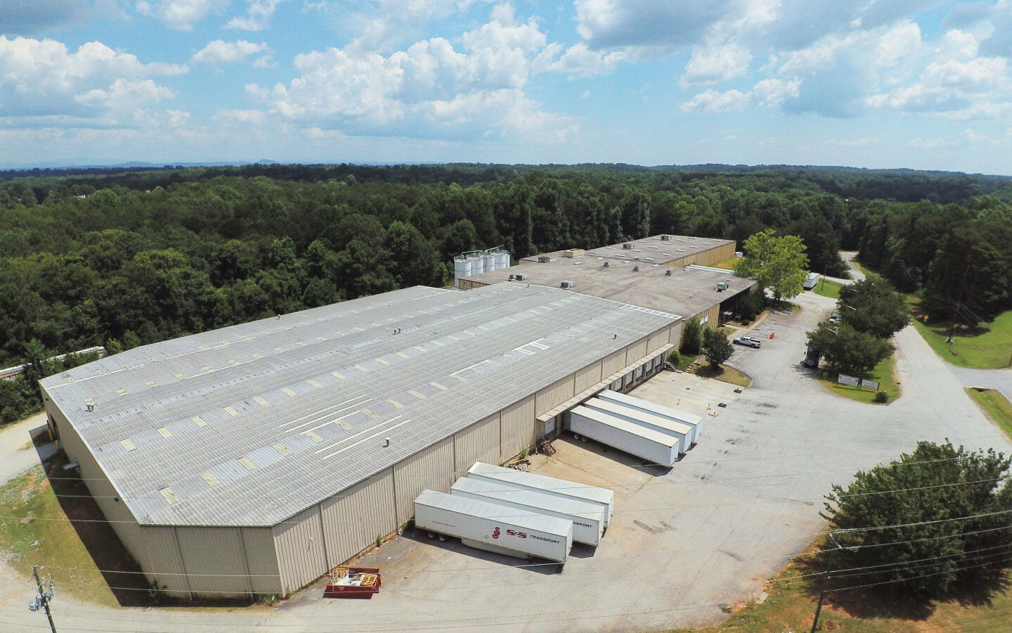
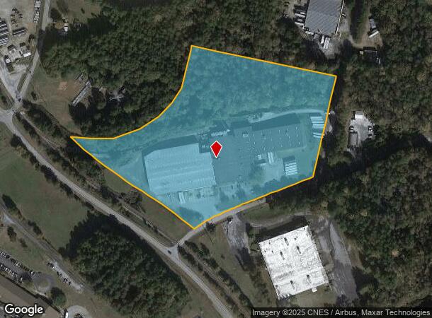
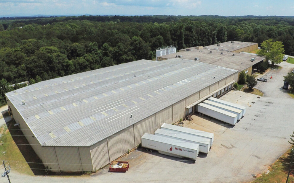
Property Record
590 Industrial Blvd, Toccoa, GA 30577
NEARBY LISTINGS FOR SALE OR LEASE
Property Detail
590 Industrial Blvd
Toccoa, GA
Toccoa Industrial District
032B-179
SITES 2, 3-B & 3-C TOCCOA INDUSTRIAL DISTRICT
Publicstorage
Stephens
X
Georgia
13257C0112D
2+
2024
11.65 AC
2024
Georgia Northeast
970302
Other Market Areas
57,769 SF
DEMOGRAPHICS near 590 Industrial Blvd
1 Mile
3 Mile
5 Mile
2024 Total Population
1,923
13,002
18,860
2029 Population
1,969
13,274
19,228
Pop Growth 2024-2029
+ 2.39%
+ 2.09%
+ 1.95%
Average Age
42
41
42
2024 Total Households
798
5,300
7,523
HH Growth 2024-2029
+ 2.13%
+ 1.96%
+ 1.89%
Median Household Inc
$52,631
$48,892
$49,946
Avg Household Size
2.40
2.40
2.40
2024 Avg HH Vehicles
2.00
2.00
2.00
Median Home Value
$130,412
$145,101
$154,940
Median Year Built
1976
1976
1979
Nearby Places
- Restaurants
- Banks
- Shops
- Fitness
- Groceries
PUBLIC TRANSPORTATION
COMMUTER RAIL
Toccoa Amtrak Station (Crescent - Amtrak)
DRIVE
WALK
Distance
Toccoa Amtrak Station (Crescent - Amtrak)
5 min
2.6 mi
Freight Ports
Georgia Ports - Savannah
DRIVE
WALK
Distance
Georgia Ports - Savannah
302 min
246.0 mi
SALE & LEASE HISTORY
LISTING DATE
SALE/LEASE

Sep 25, 2016
For Lease
Nearby Properties
Address
Land Use
TOTAL SIZE
Lot Size
Zoning
Address
Land Use
TOTAL SIZE
Lot Size
Zoning
3.47 AC
CI
Address
Land Use
TOTAL SIZE
Lot Size
Zoning
218,215 SF
25.17 AC
CG
Address
Land Use
TOTAL SIZE
Lot Size
Zoning
391,121 SF
62.73 AC
CG
Address
Land Use
TOTAL SIZE
Lot Size
Zoning
6.56 AC
CG
Address
Land Use
TOTAL SIZE
Lot Size
Zoning
4.24 AC
M-I
Address
Land Use
TOTAL SIZE
Lot Size
Zoning
49,548 SF
14.80 AC
R-II
Address
Land Use
TOTAL SIZE
Lot Size
Zoning
192,404 SF
27.79 AC
B-II
Address
Land Use
TOTAL SIZE
Lot Size
Zoning
61,105 SF
64.49 AC
CG
Address
Land Use
TOTAL SIZE
Lot Size
Zoning
Address
Land Use
TOTAL SIZE
Lot Size
Zoning
148,256 SF
24.53 AC
CI
Address
Land Use
TOTAL SIZE
Lot Size
Zoning
68,998 SF
24.53 AC
CG
Address
Land Use
TOTAL SIZE
Lot Size
Zoning
66,517 SF
10.48 AC
R-II
Address
Land Use
TOTAL SIZE
Lot Size
Zoning
23,193 SF
5.89 AC
CG
Address
Land Use
TOTAL SIZE
Lot Size
Zoning
13,568 SF
7.50 AC
B-II
Address
Land Use
TOTAL SIZE
Lot Size
Zoning
123,520 SF
25.28 AC
CI
Address
Land Use
TOTAL SIZE
Lot Size
Zoning
44,496 SF
0.93 AC
B-III
Address
Land Use
TOTAL SIZE
Lot Size
Zoning
874 AC
LI
Address
Land Use
TOTAL SIZE
Lot Size
Zoning
111,150 SF
5.91 AC
CI
Address
Land Use
TOTAL SIZE
Lot Size
Zoning
0.58 AC
CI
Address
Land Use
TOTAL SIZE
Lot Size
Zoning
39,460 SF
8.20 AC
B-II
Address
Land Use
TOTAL SIZE
Lot Size
Zoning
670 AC
LI
Address
Land Use
TOTAL SIZE
Lot Size
Zoning
Address
Land Use
TOTAL SIZE
Lot Size
Zoning
110,718 SF
10.14 AC
B-II
Address
Land Use
TOTAL SIZE
Lot Size
Zoning
34,170 SF
12.91 AC
CG
Address
Land Use
TOTAL SIZE
Lot Size
Zoning
32,440 SF
81.75 AC
R-IA
Address
Land Use
TOTAL SIZE
Lot Size
Zoning
167,500 SF
20.98 AC
CI
Address
Land Use
TOTAL SIZE
Lot Size
Zoning
11,914 SF
2.04 AC
B-I
Address
Land Use
TOTAL SIZE
Lot Size
Zoning
Address
Land Use
TOTAL SIZE
Lot Size
Zoning
19,970 SF
0.61 AC
B-III
Address
Land Use
TOTAL SIZE
Lot Size
Zoning
131,717 SF
23.47 AC
CI
The World's #1 Commercial Real Estate Marketplace
Connect with us
© 2025 CoStar Group
The information above has been obtained from sources believed reliable. While we do not doubt its accuracy we have not verified it and make no guarantee, warranty or representation about it. It is your responsibility to independently confirm its accuracy and completeness. Any projections, opinions, assumptions, or estimates used are for example only and do not represent the current or future performance of the property. The value of this transaction to you depends on tax and other factors which should be evaluated by your tax, financial, and legal advisors. You and your advisors should conduct a careful, independent investigation of the property to determine to your satisfaction the suitability of the property for your needs.