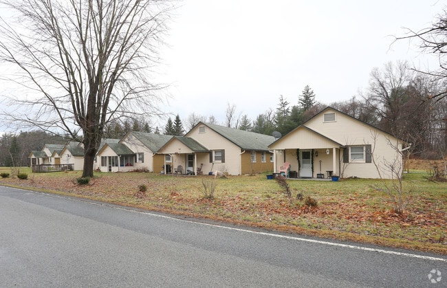
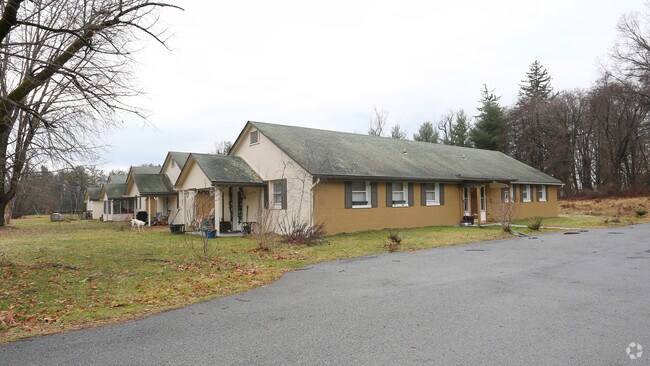
Property Record
590 Mill Rd, Rhinebeck, NY 12572


NEARBY LISTINGS FOR SALE OR LEASE
Property Detail
590 Mill Rd
135089-6068-00-866791-0000
4.87 AC (D) 1928 0359 1677 0154
Apartment
Dutchess
X
New York
36027C0143E
866
2025
4.87 AC
2024
Rhinebeck
160003
Westchester/So Connecticut
11,028 SF
Kiryas Joel-Poughkeepsie-Newburgh, NY
DEMOGRAPHICS near 590 Mill Rd
1 Mile
3 Mile
5 Mile
2024 Total Population
105
7,507
33,456
2029 Population
108
7,429
33,243
Pop Growth 2024-2029
+ 2.86%
(1.04%)
(0.64%)
Average Age
51
48
44
2024 Total Households
48
3,085
13,794
HH Growth 2024-2029
+ 4.17%
(1.13%)
(0.69%)
Median Household Inc
$93,055
$90,499
$74,689
Avg Household Size
2.00
2.20
2.20
2024 Avg HH Vehicles
1.00
2.00
2.00
Median Home Value
$478,571
$377,008
$303,222
Median Year Built
1957
1971
1957
Nearby Places
Map Layers
Map Styles
 Street
 Aerial
- Restaurants
- Banks
- Shops
- Fitness
- Groceries
PUBLIC TRANSPORTATION
COMMUTER RAIL
DRIVE
WALK
Distance
8 min
3.1 mi
DRIVE
WALK
Distance
8 min
3.1 mi
AIRPORT
New York Stewart International
DRIVE
WALK
Distance
New York Stewart International
58 min
37.6 mi
Nearby Properties
Address
Land Use
TOTAL SIZE
Lot Size
Zoning
Address
Land Use
TOTAL SIZE
Lot Size
Zoning
74,513 SF
6.90 AC
R10
Address
Land Use
TOTAL SIZE
Lot Size
Zoning
97,993 SF
18.40 AC
RA35
Address
Land Use
TOTAL SIZE
Lot Size
Zoning
162.70 AC
R20
Address
Land Use
TOTAL SIZE
Lot Size
Zoning
71,781 SF
6.50 AC
R40
Address
Land Use
TOTAL SIZE
Lot Size
Zoning
68,465 SF
2.80 AC
R35
Address
Land Use
TOTAL SIZE
Lot Size
Zoning
32,044 SF
51.24 AC
HP20
Address
Land Use
TOTAL SIZE
Lot Size
Zoning
172.24 AC
HP20
Address
Land Use
TOTAL SIZE
Lot Size
Zoning
88,000 SF
6.90 AC
GC
Address
Land Use
TOTAL SIZE
Lot Size
Zoning
133,760 SF
31.25 AC
LI
Address
Land Use
TOTAL SIZE
Lot Size
Zoning
10,581 SF
37.69 AC
HP20
Address
Land Use
TOTAL SIZE
Lot Size
Zoning
28,774 SF
9.11 AC
PUD
Address
Land Use
TOTAL SIZE
Lot Size
Zoning
9,359 SF
112.03 AC
RC5
Address
Land Use
TOTAL SIZE
Lot Size
Zoning
46,569 SF
1.54 AC
R3500
Address
Land Use
TOTAL SIZE
Lot Size
Zoning
9,167 SF
34.20 AC
HP20
Address
Land Use
TOTAL SIZE
Lot Size
Zoning
31,598 SF
40.24 AC
RA10
Address
Land Use
TOTAL SIZE
Lot Size
Zoning
8,924 SF
10.66 AC
RC5
Address
Land Use
TOTAL SIZE
Lot Size
Zoning
902 SF
538.31 AC
RA10
Address
Land Use
TOTAL SIZE
Lot Size
Zoning
13,306 SF
72.74 AC
RA10
Address
Land Use
TOTAL SIZE
Lot Size
Zoning
10,100 SF
1.50 AC
R1000
Address
Land Use
TOTAL SIZE
Lot Size
Zoning
50,867 SF
136 AC
RC5
Address
Land Use
TOTAL SIZE
Lot Size
Zoning
46,948 SF
17.30 AC
R12
Address
Land Use
TOTAL SIZE
Lot Size
Zoning
77,650 SF
4.20 AC
LI
Address
Land Use
TOTAL SIZE
Lot Size
Zoning
18,853 SF
1.40 AC
GB
Address
Land Use
TOTAL SIZE
Lot Size
Zoning
24,956 SF
100 AC
WF
Address
Land Use
TOTAL SIZE
Lot Size
Zoning
7,293 SF
20.45 AC
HP20
Address
Land Use
TOTAL SIZE
Lot Size
Zoning
12,732 SF
0.77 AC
GB
Address
Land Use
TOTAL SIZE
Lot Size
Zoning
170.76 AC
RA10
Address
Land Use
TOTAL SIZE
Lot Size
Zoning
8,998 SF
68.40 AC
RC5
Address
Land Use
TOTAL SIZE
Lot Size
Zoning
6,911 SF
2.35 AC
RT
Address
Land Use
TOTAL SIZE
Lot Size
Zoning
6,420 SF
0.50 AC
R12
The World's #1 Commercial Real Estate Marketplace
Connect with us
© 2026 CoStar Group
The information above has been obtained from sources believed reliable. While we do not doubt its accuracy we have not verified it and make no guarantee, warranty or representation about it. It is your responsibility to independently confirm its accuracy and completeness. Any projections, opinions, assumptions, or estimates used are for example only and do not represent the current or future performance of the property. The value of this transaction to you depends on tax and other factors which should be evaluated by your tax, financial, and legal advisors. You and your advisors should conduct a careful, independent investigation of the property to determine to your satisfaction the suitability of the property for your needs.