Property Record
5915 N Richmond St, Appleton, WI 54913
NEARBY LISTINGS FOR SALE OR LEASE
-
-
-
-
-
I-41 & Richmond St @ W. Evergreen Drive
Appleton, WI 54913
$544,500 - $6,742,217
1.50 - 16.80 AC Lot
Land
-
-
-
View all Appleton listings for sale on LoopNet.com
Property Detail
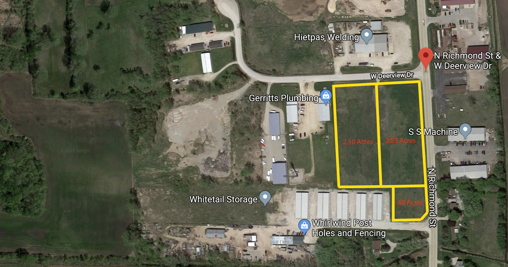
5915 N Richmond St
10-1-0112-00
LOT 1 CSM 8267
Commercialnec
Outagamie
X
Wisconsin
55087C0308E
5.12 AC
2023
Outagamie County
2023
Green Bay
012503
Appleton, WI
26,258 SF
DEMOGRAPHICS near 5915 N Richmond St
1 Mile
3 Mile
5 Mile
2024 Total Population
1,161
28,024
83,724
2029 Population
1,208
28,999
86,901
Pop Growth 2024-2029
+ 4.05%
+ 3.48%
+ 3.79%
Average Age
42
42
40
2024 Total Households
428
11,200
34,552
HH Growth 2024-2029
+ 3.97%
+ 3.40%
+ 3.83%
Median Household Inc
$136,301
$91,249
$72,438
Avg Household Size
2.70
2.40
2.30
2024 Avg HH Vehicles
2.00
2.00
2.00
Median Home Value
$364,893
$293,617
$222,729
Median Year Built
2001
1992
1977
Nearby Places
- Restaurants
- Banks
- Shops
- Fitness
- Groceries
PUBLIC TRANSPORTATION
AIRPORT
Appleton International
DRIVE
WALK
Distance
Appleton International
17 min
11.2 mi
Green Bay/Austin Straubel International
DRIVE
WALK
Distance
Green Bay/Austin Straubel International
35 min
27.3 mi
Freight Ports
Port Milwaukee
DRIVE
WALK
Distance
Port Milwaukee
130 min
113.0 mi
SALE & LEASE HISTORY
LISTING DATE
SALE/LEASE

Jun 04, 2019
For Sale
Nearby Properties
Address
Land Use
TOTAL SIZE
Lot Size
Zoning
Address
Land Use
TOTAL SIZE
Lot Size
Zoning
500,700 SF
47.17 AC
Address
Land Use
TOTAL SIZE
Lot Size
Zoning
189,107 SF
13.37 AC
Address
Land Use
TOTAL SIZE
Lot Size
Zoning
70,136 SF
6.34 AC
C2
Address
Land Use
TOTAL SIZE
Lot Size
Zoning
2,032 SF
18.48 AC
R3
Address
Land Use
TOTAL SIZE
Lot Size
Zoning
65,818 SF
8.01 AC
C2
Address
Land Use
TOTAL SIZE
Lot Size
Zoning
6.58 AC
M1
Address
Land Use
TOTAL SIZE
Lot Size
Zoning
194,573 SF
19.99 AC
Address
Land Use
TOTAL SIZE
Lot Size
Zoning
40,560 SF
6.66 AC
R3
Address
Land Use
TOTAL SIZE
Lot Size
Zoning
107,202 SF
39.98 AC
C2
Address
Land Use
TOTAL SIZE
Lot Size
Zoning
66,504 SF
5.25 AC
C2
Address
Land Use
TOTAL SIZE
Lot Size
Zoning
14,024 SF
9.34 AC
PDR3
Address
Land Use
TOTAL SIZE
Lot Size
Zoning
15,560 SF
15.24 AC
Address
Land Use
TOTAL SIZE
Lot Size
Zoning
Address
Land Use
TOTAL SIZE
Lot Size
Zoning
13,994 SF
8.13 AC
R3
Address
Land Use
TOTAL SIZE
Lot Size
Zoning
83,926 SF
7.35 AC
C2
Address
Land Use
TOTAL SIZE
Lot Size
Zoning
22.26 AC
Address
Land Use
TOTAL SIZE
Lot Size
Zoning
7,979 SF
6.64 AC
C2
Address
Land Use
TOTAL SIZE
Lot Size
Zoning
40,560 SF
3.69 AC
R3
Address
Land Use
TOTAL SIZE
Lot Size
Zoning
65,174 SF
9.13 AC
C2
Address
Land Use
TOTAL SIZE
Lot Size
Zoning
Address
Land Use
TOTAL SIZE
Lot Size
Zoning
1,160 SF
4.70 AC
R3
Address
Land Use
TOTAL SIZE
Lot Size
Zoning
18,764 SF
318.60 AC
PDC2
Address
Land Use
TOTAL SIZE
Lot Size
Zoning
3,173 SF
4.02 AC
R3
Address
Land Use
TOTAL SIZE
Lot Size
Zoning
24,272 SF
2.44 AC
C2
Address
Land Use
TOTAL SIZE
Lot Size
Zoning
4,869 SF
5.70 AC
PDR3
Address
Land Use
TOTAL SIZE
Lot Size
Zoning
16,716 SF
4.90 AC
PDR3
Address
Land Use
TOTAL SIZE
Lot Size
Zoning
1,008 SF
13.19 AC
M1
Address
Land Use
TOTAL SIZE
Lot Size
Zoning
13,252 SF
0.29 AC
Address
Land Use
TOTAL SIZE
Lot Size
Zoning
17,888 SF
0.29 AC
Address
Land Use
TOTAL SIZE
Lot Size
Zoning
71,640 SF
2.14 AC
C2
The World's #1 Commercial Real Estate Marketplace
Connect with us
© 2025 CoStar Group
The information above has been obtained from sources believed reliable. While we do not doubt its accuracy we have not verified it and make no guarantee, warranty or representation about it. It is your responsibility to independently confirm its accuracy and completeness. Any projections, opinions, assumptions, or estimates used are for example only and do not represent the current or future performance of the property. The value of this transaction to you depends on tax and other factors which should be evaluated by your tax, financial, and legal advisors. You and your advisors should conduct a careful, independent investigation of the property to determine to your satisfaction the suitability of the property for your needs.