Property Record
5924 Regal Estate Ln, Charlotte, NC 28212


NEARBY LISTINGS FOR SALE OR LEASE
-
-
View all Charlotte listings for sale on LoopNet.com
Property Detail
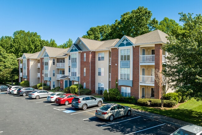
5924 Regal Estate Ln
103-111-21
Crown Ridge Apartments
Multifamilydwelling
Mecklenburg
X
North Carolina
3710457300K
17
2024
12.56 AC
2025
Eastland-Wilora Lake
001607
Charlotte
176,738 SF
Charlotte-Concord-Gastonia, NC-SC
DEMOGRAPHICS near 5924 Regal Estate Ln
1 Mile
3 Mile
5 Mile
2024 Total Population
18,850
110,478
257,048
2029 Population
19,846
116,021
272,011
Pop Growth 2024-2029
+ 5.28%
+ 5.02%
+ 5.82%
Average Age
34
36
37
2024 Total Households
7,110
42,850
103,862
HH Growth 2024-2029
+ 5.39%
+ 5.10%
+ 5.94%
Median Household Inc
$42,588
$51,485
$61,406
Avg Household Size
2.60
2.50
2.40
2024 Avg HH Vehicles
1.00
2.00
2.00
Median Home Value
$213,616
$238,462
$297,528
Median Year Built
1977
1977
1982
Nearby Places
Map Layers
Map Styles
 Street
 Aerial
- Restaurants
- Banks
- Shops
- Fitness
- Groceries
PUBLIC TRANSPORTATION
COMMUTER RAIL
DRIVE
WALK
Distance
14 min
7.6 mi
AIRPORT
Charlotte/Douglas International
DRIVE
WALK
Distance
Charlotte/Douglas International
27 min
14.4 mi
Concord-Padgett Regional
DRIVE
WALK
Distance
Concord-Padgett Regional
29 min
16.7 mi
Nearby Properties
Address
Land Use
TOTAL SIZE
Lot Size
Zoning
Address
Land Use
TOTAL SIZE
Lot Size
Zoning
690,862 SF
136.80 AC
R17MF
Address
Land Use
TOTAL SIZE
Lot Size
Zoning
450,292 SF
28.95 AC
R22MF
Address
Land Use
TOTAL SIZE
Lot Size
Zoning
344,226 SF
18.83 AC
B2
Address
Land Use
TOTAL SIZE
Lot Size
Zoning
258,272 SF
22.10 AC
R9MFCD
Address
Land Use
TOTAL SIZE
Lot Size
Zoning
299,998 SF
19.55 AC
R17MF
Address
Land Use
TOTAL SIZE
Lot Size
Zoning
325,177 SF
43.11 AC
R12MFCD
Address
Land Use
TOTAL SIZE
Lot Size
Zoning
347,952 SF
28.37 AC
OACUD
Address
Land Use
TOTAL SIZE
Lot Size
Zoning
300,346 SF
45.50 AC
R3
Address
Land Use
TOTAL SIZE
Lot Size
Zoning
311,245 SF
16.83 AC
INSTCD
Address
Land Use
TOTAL SIZE
Lot Size
Zoning
324,323 SF
31.39 AC
R17MF
Address
Land Use
TOTAL SIZE
Lot Size
Zoning
316,763 SF
21.18 AC
R17MF
Address
Land Use
TOTAL SIZE
Lot Size
Zoning
280,386 SF
22.75 AC
R17MF
Address
Land Use
TOTAL SIZE
Lot Size
Zoning
270,091 SF
32.43 AC
R17MF
Address
Land Use
TOTAL SIZE
Lot Size
Zoning
322,517 SF
30.74 AC
R15MFCD
Address
Land Use
TOTAL SIZE
Lot Size
Zoning
197,180 SF
4.89 AC
Address
Land Use
TOTAL SIZE
Lot Size
Zoning
208,846 SF
14.99 AC
R17MF
Address
Land Use
TOTAL SIZE
Lot Size
Zoning
197,367 SF
6.07 AC
Address
Land Use
TOTAL SIZE
Lot Size
Zoning
193,365 SF
15.06 AC
R17MF
Address
Land Use
TOTAL SIZE
Lot Size
Zoning
205,701 SF
13.73 AC
OACUD
Address
Land Use
TOTAL SIZE
Lot Size
Zoning
249,650 SF
20.17 AC
R17MF
Address
Land Use
TOTAL SIZE
Lot Size
Zoning
207,338 SF
13.96 AC
R17MF
Address
Land Use
TOTAL SIZE
Lot Size
Zoning
131,657 SF
30.34 AC
R-4
Address
Land Use
TOTAL SIZE
Lot Size
Zoning
306,762 SF
21.23 AC
R17MF
Address
Land Use
TOTAL SIZE
Lot Size
Zoning
177,855 SF
9.14 AC
O2
Address
Land Use
TOTAL SIZE
Lot Size
Zoning
188,607 SF
10.68 AC
R22MF
Address
Land Use
TOTAL SIZE
Lot Size
Zoning
166,800 SF
19.50 AC
R17MF
Address
Land Use
TOTAL SIZE
Lot Size
Zoning
220,767 SF
40.75 AC
R17MF
Address
Land Use
TOTAL SIZE
Lot Size
Zoning
170,913 SF
11.36 AC
R17MF
Address
Land Use
TOTAL SIZE
Lot Size
Zoning
206,533 SF
14.13 AC
R22MF
Address
Land Use
TOTAL SIZE
Lot Size
Zoning
134,161 SF
11.40 AC
R-4
The World's #1 Commercial Real Estate Marketplace
Connect with us
© 2026 CoStar Group
The information above has been obtained from sources believed reliable. While we do not doubt its accuracy we have not verified it and make no guarantee, warranty or representation about it. It is your responsibility to independently confirm its accuracy and completeness. Any projections, opinions, assumptions, or estimates used are for example only and do not represent the current or future performance of the property. The value of this transaction to you depends on tax and other factors which should be evaluated by your tax, financial, and legal advisors. You and your advisors should conduct a careful, independent investigation of the property to determine to your satisfaction the suitability of the property for your needs.