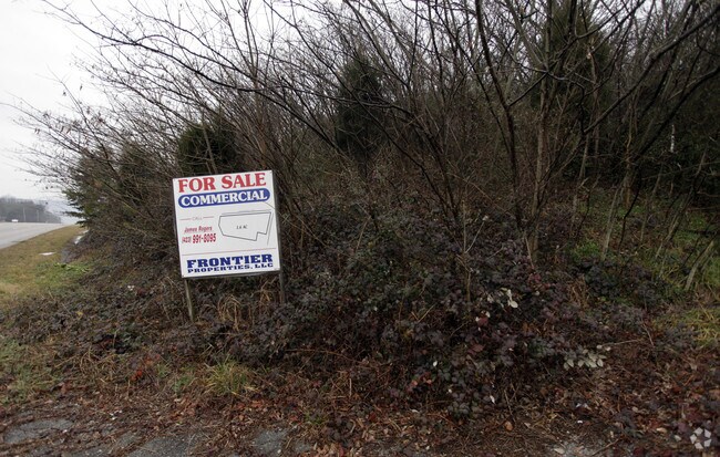
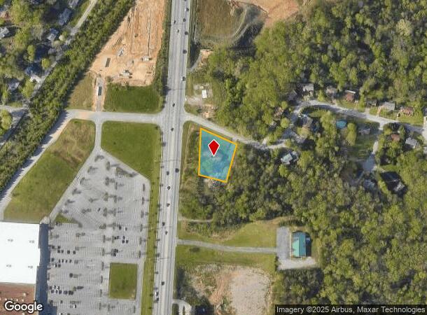
Property Record
411 Stoneridge Dr, Hixson, TN 37343

NEARBY LISTINGS FOR SALE OR LEASE
Property Detail
411 Stoneridge Dr
Chattanooga, TN-GA
Hixson W C Tract
091I-B-006
Hamilton
Sfr
Tennessee
X
0.72 AC
47065C0236G
Outlying Hamilton County
1,568 SF
Chattanooga
DEMOGRAPHICS near 411 Stoneridge Dr
1 Mile
3 Mile
5 Mile
2024 Total Population
3,740
28,835
66,384
2029 Population
3,922
30,732
70,641
Pop Growth 2024-2029
+ 4.87%
+ 6.58%
+ 6.41%
Average Age
41
43
42
2024 Total Households
1,531
11,829
27,419
HH Growth 2024-2029
+ 5.03%
+ 6.79%
+ 6.59%
Median Household Inc
$66,890
$71,649
$77,391
Avg Household Size
2.40
2.40
2.40
2024 Avg HH Vehicles
2.00
2.00
2.00
Median Home Value
$210,667
$242,857
$255,037
Median Year Built
1977
1981
1978
Nearby Places
Map Layers
Map Styles
 Street
 Aerial
- Restaurants
- Banks
- Shops
- Fitness
- Groceries
PUBLIC TRANSPORTATION
AIRPORT
Lovell Field
DRIVE
WALK
Distance
Lovell Field
20 min
13.6 mi
Freight Ports
Georgia Ports - Savannah
DRIVE
WALK
Distance
Georgia Ports - Savannah
1 min
315.8 mi
SALE & LEASE HISTORY
LISTING DATE
SALE/LEASE

Feb 27, 2019
For Sale
Nearby Properties
Address
Land Use
TOTAL SIZE
Lot Size
Zoning
Address
Land Use
TOTAL SIZE
Lot Size
Zoning
197,214 SF
19.39 AC
R4
Address
Land Use
TOTAL SIZE
Lot Size
Zoning
286,637 SF
20.40 AC
Address
Land Use
TOTAL SIZE
Lot Size
Zoning
292,937 SF
21.50 AC
R1
Address
Land Use
TOTAL SIZE
Lot Size
Zoning
139,820 SF
12.67 AC
R3
Address
Land Use
TOTAL SIZE
Lot Size
Zoning
149,270 SF
9.25 AC
R4
Address
Land Use
TOTAL SIZE
Lot Size
Zoning
182,466 SF
20.95 AC
R5
Address
Land Use
TOTAL SIZE
Lot Size
Zoning
341,649 SF
38.44 AC
C2
Address
Land Use
TOTAL SIZE
Lot Size
Zoning
88,449 SF
4 AC
Address
Land Use
TOTAL SIZE
Lot Size
Zoning
20,880 SF
14.13 AC
R3
Address
Land Use
TOTAL SIZE
Lot Size
Zoning
91,520 SF
10.99 AC
C2
Address
Land Use
TOTAL SIZE
Lot Size
Zoning
125,681 SF
5.55 AC
M3
Address
Land Use
TOTAL SIZE
Lot Size
Zoning
215,672 SF
21.28 AC
Address
Land Use
TOTAL SIZE
Lot Size
Zoning
76,589 SF
9.71 AC
R4
Address
Land Use
TOTAL SIZE
Lot Size
Zoning
31,511 SF
5.48 AC
Address
Land Use
TOTAL SIZE
Lot Size
Zoning
47,343 SF
4.06 AC
Address
Land Use
TOTAL SIZE
Lot Size
Zoning
79,260 SF
10.92 AC
C2
Address
Land Use
TOTAL SIZE
Lot Size
Zoning
87,930 SF
4 AC
Address
Land Use
TOTAL SIZE
Lot Size
Zoning
12,432 SF
6.41 AC
Address
Land Use
TOTAL SIZE
Lot Size
Zoning
137,151 SF
10.35 AC
M2
Address
Land Use
TOTAL SIZE
Lot Size
Zoning
18,432 SF
9.32 AC
R3
Address
Land Use
TOTAL SIZE
Lot Size
Zoning
141,549 SF
12.56 AC
C2
Address
Land Use
TOTAL SIZE
Lot Size
Zoning
25,617 SF
8 AC
R1
Address
Land Use
TOTAL SIZE
Lot Size
Zoning
116,325 SF
9.76 AC
C2
Address
Land Use
TOTAL SIZE
Lot Size
Zoning
71,580 SF
10.62 AC
Address
Land Use
TOTAL SIZE
Lot Size
Zoning
125,453 SF
10.87 AC
C2
Address
Land Use
TOTAL SIZE
Lot Size
Zoning
112,896 SF
11.19 AC
C2
Address
Land Use
TOTAL SIZE
Lot Size
Zoning
193.96 AC
Address
Land Use
TOTAL SIZE
Lot Size
Zoning
55,185 SF
1.51 AC
C2
Address
Land Use
TOTAL SIZE
Lot Size
Zoning
167,822 SF
22.84 AC
M2
Address
Land Use
TOTAL SIZE
Lot Size
Zoning
81,166 SF
4.27 AC
The World's #1 Commercial Real Estate Marketplace
Connect with us
© 2026 CoStar Group
The information above has been obtained from sources believed reliable. While we do not doubt its accuracy we have not verified it and make no guarantee, warranty or representation about it. It is your responsibility to independently confirm its accuracy and completeness. Any projections, opinions, assumptions, or estimates used are for example only and do not represent the current or future performance of the property. The value of this transaction to you depends on tax and other factors which should be evaluated by your tax, financial, and legal advisors. You and your advisors should conduct a careful, independent investigation of the property to determine to your satisfaction the suitability of the property for your needs.