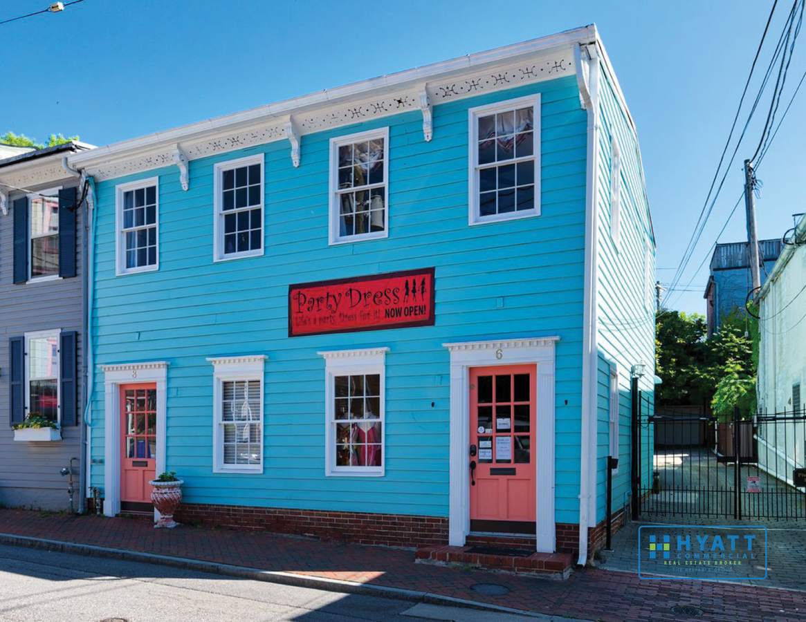
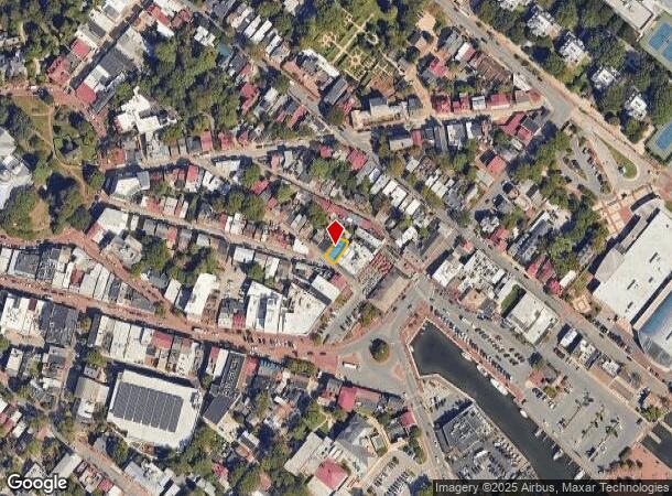
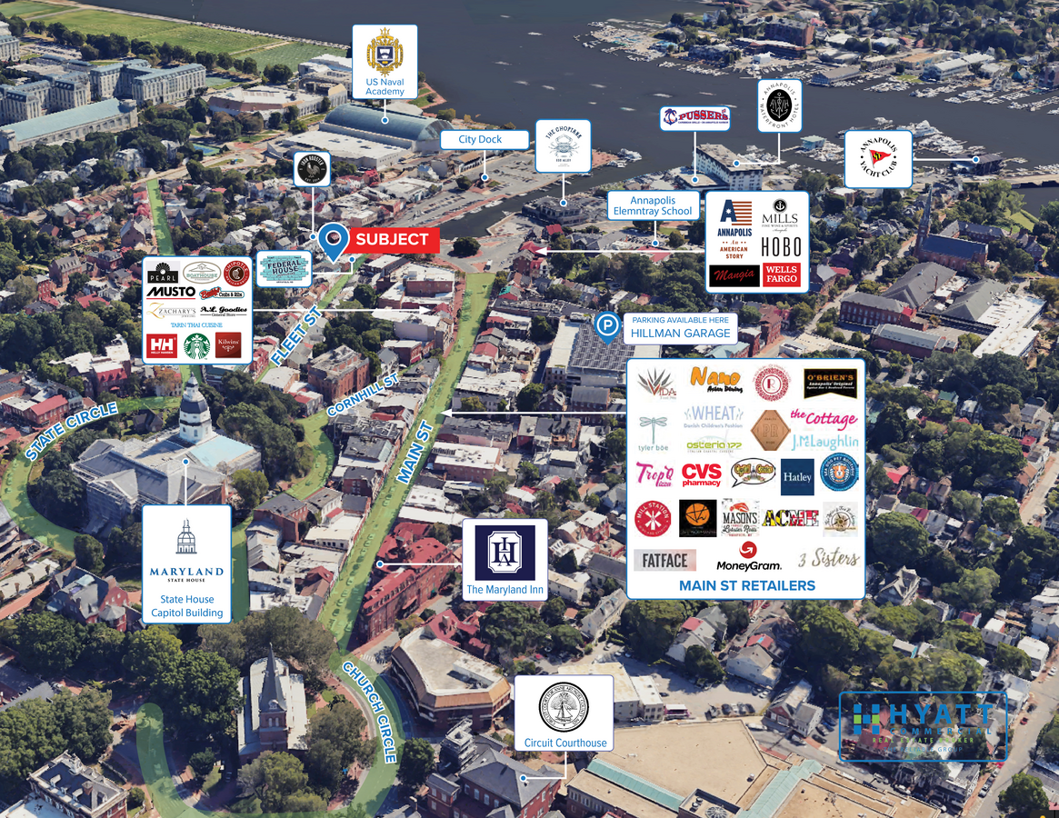
Property Record
6 Fleet St, Annapolis, MD 21401

NEARBY LISTINGS FOR SALE OR LEASE
Property Detail
6 Fleet St
06-000-04692602
Annapolis
Storebuilding
1611 SQFT ANNAPOLIS
X
Anne Arundel
24003C0251F
Maryland
2024
0.04 AC
2024
Annapolis
706103
Baltimore
2,751 SF
Baltimore-Columbia-Towson, MD
DEMOGRAPHICS near 6 Fleet St
1 Mile
3 Mile
5 Mile
2024 Total Population
12,054
60,227
109,720
2029 Population
12,505
62,108
112,813
Pop Growth 2024-2029
+ 3.74%
+ 3.12%
+ 2.82%
Average Age
44
41
42
2024 Total Households
5,652
25,070
44,422
HH Growth 2024-2029
+ 3.87%
+ 3.24%
+ 2.92%
Median Household Inc
$108,302
$105,982
$116,941
Avg Household Size
2.10
2.30
2.40
2024 Avg HH Vehicles
2.00
2.00
2.00
Median Home Value
$785,067
$532,950
$533,900
Median Year Built
1963
1977
1980
Nearby Places
- Restaurants
- Banks
- Shops
- Fitness
- Groceries
PUBLIC TRANSPORTATION
AIRPORT
Baltimore/Washington International Thurgood Marshall
DRIVE
WALK
Distance
Baltimore/Washington International Thurgood Marshall
35 min
25.1 mi
Freight Ports
Port of Baltimore
DRIVE
WALK
Distance
Port of Baltimore
43 min
30.7 mi
SALE & LEASE HISTORY
LISTING DATE
SALE/LEASE

Nov 09, 2022
For Lease
Feb 01, 2024
For Lease
Nearby Properties
Address
Land Use
TOTAL SIZE
Lot Size
Zoning
Address
Land Use
TOTAL SIZE
Lot Size
Zoning
717,491 SF
26.28 AC
C2
Address
Land Use
TOTAL SIZE
Lot Size
Zoning
6,400 SF
31.17 AC
C1
Address
Land Use
TOTAL SIZE
Lot Size
Zoning
434,112 SF
822.11 AC
R1
Address
Land Use
TOTAL SIZE
Lot Size
Zoning
31.16 AC
R4
Address
Land Use
TOTAL SIZE
Lot Size
Zoning
406,976 SF
18.98 AC
R2
Address
Land Use
TOTAL SIZE
Lot Size
Zoning
296,790 SF
27.74 AC
TC
Address
Land Use
TOTAL SIZE
Lot Size
Zoning
58.99 AC
R2
Address
Land Use
TOTAL SIZE
Lot Size
Zoning
250,163 SF
2.19 AC
P
Address
Land Use
TOTAL SIZE
Lot Size
Zoning
577,560 SF
3.71 AC
C2
Address
Land Use
TOTAL SIZE
Lot Size
Zoning
346,335 SF
16.42 AC
R22
Address
Land Use
TOTAL SIZE
Lot Size
Zoning
389,081 SF
4.79 AC
TC
Address
Land Use
TOTAL SIZE
Lot Size
Zoning
271,003 SF
1 AC
TC
Address
Land Use
TOTAL SIZE
Lot Size
Zoning
198,795 SF
36 AC
R2
Address
Land Use
TOTAL SIZE
Lot Size
Zoning
341,468 SF
1.82 AC
TC
Address
Land Use
TOTAL SIZE
Lot Size
Zoning
248,820 SF
24.92 AC
R2
Address
Land Use
TOTAL SIZE
Lot Size
Zoning
435,081 SF
2.62 AC
TC
Address
Land Use
TOTAL SIZE
Lot Size
Zoning
272,275 SF
3.11 AC
P
Address
Land Use
TOTAL SIZE
Lot Size
Zoning
146,329 SF
1.26 AC
WMC
Address
Land Use
TOTAL SIZE
Lot Size
Zoning
309,756 SF
218 SF
R-22
Address
Land Use
TOTAL SIZE
Lot Size
Zoning
8.78 AC
R3
Address
Land Use
TOTAL SIZE
Lot Size
Zoning
389,242 SF
11.56 AC
C2
Address
Land Use
TOTAL SIZE
Lot Size
Zoning
189,134 SF
1.02 AC
MX
Address
Land Use
TOTAL SIZE
Lot Size
Zoning
199,311 SF
1 AC
MX
Address
Land Use
TOTAL SIZE
Lot Size
Zoning
14.42 AC
R3
Address
Land Use
TOTAL SIZE
Lot Size
Zoning
117,577 SF
6.92 AC
R2
Address
Land Use
TOTAL SIZE
Lot Size
Zoning
25,990 SF
32.06 AC
C2
Address
Land Use
TOTAL SIZE
Lot Size
Zoning
118,260 SF
34.01 AC
Address
Land Use
TOTAL SIZE
Lot Size
Zoning
37.74 AC
R3
Address
Land Use
TOTAL SIZE
Lot Size
Zoning
175,294 SF
13.82 AC
W1
Address
Land Use
TOTAL SIZE
Lot Size
Zoning
160,914 SF
20.63 AC
TC
The World's #1 Commercial Real Estate Marketplace
Connect with us
© 2025 CoStar Group
The information above has been obtained from sources believed reliable. While we do not doubt its accuracy we have not verified it and make no guarantee, warranty or representation about it. It is your responsibility to independently confirm its accuracy and completeness. Any projections, opinions, assumptions, or estimates used are for example only and do not represent the current or future performance of the property. The value of this transaction to you depends on tax and other factors which should be evaluated by your tax, financial, and legal advisors. You and your advisors should conduct a careful, independent investigation of the property to determine to your satisfaction the suitability of the property for your needs.