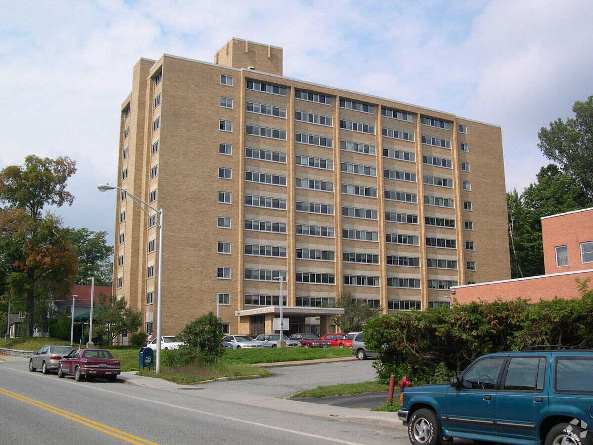
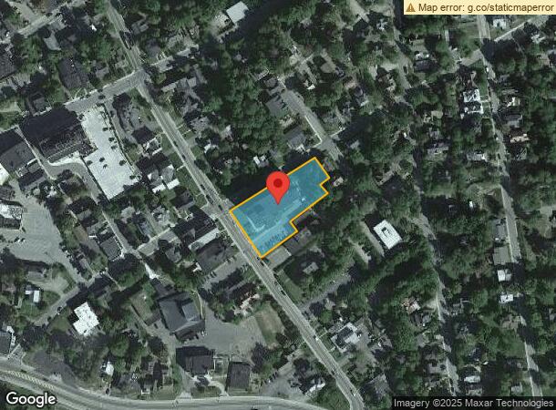
Property Record
60 Church St, Saranac Lake, NY 12983
NEARBY LISTINGS FOR SALE OR LEASE
-
-
View all Saranac Lake listings for sale on LoopNet.com
Property Detail
60 Church St
Malone, NY
DECHANTEL APTS PARKING LOT
164601-447-078-0004-001-000-0000
Franklin
Apartment
New York
0
1.000
2023
1 AC
950900
Upstate New York Area
102,578 SF
Other Market Areas
DEMOGRAPHICS near 60 Church St
1 Mile
3 Mile
5 Mile
2024 Total Population
4,990
6,940
7,240
2029 Population
5,036
6,989
7,283
Pop Growth 2024-2029
+ 0.92%
+ 0.71%
+ 0.59%
Average Age
43
43
44
2024 Total Households
2,454
3,236
3,369
HH Growth 2024-2029
+ 0.81%
+ 0.68%
+ 0.56%
Median Household Inc
$56,552
$59,483
$59,975
Avg Household Size
1.90
2.00
2.00
2024 Avg HH Vehicles
1.00
1.00
1.00
Median Home Value
$174,166
$185,580
$186,374
Median Year Built
1949
1952
1951
Nearby Places
- Restaurants
- Banks
- Shops
- Fitness
- Groceries
Nearby Properties
Address
Land Use
TOTAL SIZE
Lot Size
Zoning
Address
Land Use
TOTAL SIZE
Lot Size
Zoning
17,342 SF
161.99 AC
08 - GOVER
Address
Land Use
TOTAL SIZE
Lot Size
Zoning
25,000 SF
52.42 AC
08 - GOVER
Address
Land Use
TOTAL SIZE
Lot Size
Zoning
127,726 SF
35 AC
07 - MIXED
Address
Land Use
TOTAL SIZE
Lot Size
Zoning
3,750 AC
02 - SINGL
Address
Land Use
TOTAL SIZE
Lot Size
Zoning
52,932 SF
140 AC
07 - MIXED
Address
Land Use
TOTAL SIZE
Lot Size
Zoning
148,992 SF
45.23 AC
07 - MIXED
Address
Land Use
TOTAL SIZE
Lot Size
Zoning
105,680 SF
16.72 AC
07 - MIXED
Address
Land Use
TOTAL SIZE
Lot Size
Zoning
30,991 SF
14.50 AC
07 - MIXED
Address
Land Use
TOTAL SIZE
Lot Size
Zoning
50,000 SF
4.41 AC
08 - GOVER
Address
Land Use
TOTAL SIZE
Lot Size
Zoning
5 AC
01 - NOT Z
Address
Land Use
TOTAL SIZE
Lot Size
Zoning
68,292 SF
2.80 AC
07 - MIXED
Address
Land Use
TOTAL SIZE
Lot Size
Zoning
41,742 SF
7.49 AC
02 - SINGL
Address
Land Use
TOTAL SIZE
Lot Size
Zoning
17,163 SF
10.70 AC
07 - MIXED
Address
Land Use
TOTAL SIZE
Lot Size
Zoning
11,642 SF
102.10 AC
02 - SINGL
Address
Land Use
TOTAL SIZE
Lot Size
Zoning
53,112 SF
0.56 AC
05 - COMME
Address
Land Use
TOTAL SIZE
Lot Size
Zoning
59,094 SF
1.41 AC
07 - MIXED
Address
Land Use
TOTAL SIZE
Lot Size
Zoning
7,306 SF
64.02 AC
01 - NOT Z
Address
Land Use
TOTAL SIZE
Lot Size
Zoning
10,000 SF
98.90 AC
08 - GOVER
Address
Land Use
TOTAL SIZE
Lot Size
Zoning
8,960 SF
4.13 AC
07 - MIXED
Address
Land Use
TOTAL SIZE
Lot Size
Zoning
66,504 SF
6.90 AC
07 - MIXED
Address
Land Use
TOTAL SIZE
Lot Size
Zoning
1,680 SF
12.30 AC
01 - NOT Z
Address
Land Use
TOTAL SIZE
Lot Size
Zoning
9,476 SF
8 AC
07 - MIXED
Address
Land Use
TOTAL SIZE
Lot Size
Zoning
33,494 SF
2.91 AC
05 - COMME
Address
Land Use
TOTAL SIZE
Lot Size
Zoning
15,110 SF
4.66 AC
07 - MIXED
Address
Land Use
TOTAL SIZE
Lot Size
Zoning
39,354 SF
21.70 AC
02 - SINGL
Address
Land Use
TOTAL SIZE
Lot Size
Zoning
9,024 SF
9.96 AC
02 - SINGL
Address
Land Use
TOTAL SIZE
Lot Size
Zoning
6,530 SF
124.98 AC
02 - SINGL
Address
Land Use
TOTAL SIZE
Lot Size
Zoning
51,539 SF
2.87 AC
07 - MIXED
Address
Land Use
TOTAL SIZE
Lot Size
Zoning
20,305 SF
29.10 AC
07 - MIXED
Address
Land Use
TOTAL SIZE
Lot Size
Zoning
10,240 SF
2.61 AC
01 - NOT Z
The World's #1 Commercial Real Estate Marketplace
Connect with us
© 2025 CoStar Group
The information above has been obtained from sources believed reliable. While we do not doubt its accuracy we have not verified it and make no guarantee, warranty or representation about it. It is your responsibility to independently confirm its accuracy and completeness. Any projections, opinions, assumptions, or estimates used are for example only and do not represent the current or future performance of the property. The value of this transaction to you depends on tax and other factors which should be evaluated by your tax, financial, and legal advisors. You and your advisors should conduct a careful, independent investigation of the property to determine to your satisfaction the suitability of the property for your needs.