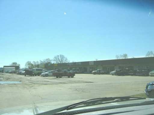
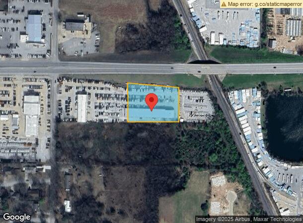
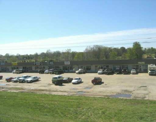
Property Record
600 E 600-622 412 Hwy E, Siloam Springs, AR 72761
NEARBY LISTINGS FOR SALE OR LEASE
Property Detail
600 E 600-622 412 Hwy E
Fayetteville-Springdale-Rogers, AR-MO
Bob Gray Horiz Prop-Siloam Springs
03-00210-001
PART 3, WINDERS SUBDIVISION, SILOAM SPRINGS, BEING A PART OF THE NE1/4 OF THE NE 114 OF SECTION 7, TOWNSHIP 17 NORTH, RANGE 33 WEST, BENTON COUNTY, ARKANSAS, AS SHOWN IN DEED RECORD 57 AT PAGE 29, FLAT RECORD 7 AT PAGE 106, AND IN THE MASTER DEED FOR
Autorepair
Benton
X
Arkansas
40041C0600E
3
2024
1.72 AC
2024
Outlying Benton County
021101
Fayetteville/Springdale/Rogers
12,850 SF
DEMOGRAPHICS near 600 E 600-622 412 Hwy E
1 Mile
3 Mile
5 Mile
2024 Total Population
5,020
21,596
26,374
2029 Population
5,904
25,358
30,804
Pop Growth 2024-2029
+ 17.61%
+ 17.42%
+ 16.80%
Average Age
36
36
37
2024 Total Households
1,770
7,446
9,142
HH Growth 2024-2029
+ 17.63%
+ 17.47%
+ 16.79%
Median Household Inc
$55,231
$60,294
$61,437
Avg Household Size
2.80
2.70
2.70
2024 Avg HH Vehicles
2.00
2.00
2.00
Median Home Value
$187,437
$190,189
$194,398
Median Year Built
1988
1992
1992
Nearby Places
- Restaurants
- Banks
- Shops
- Fitness
- Groceries
PUBLIC TRANSPORTATION
AIRPORT
Northwest Arkansas Ntl
DRIVE
WALK
Distance
Northwest Arkansas Ntl
41 min
22.3 mi
Freight Ports
Tulsa Port of Inola
DRIVE
WALK
Distance
Tulsa Port of Inola
69 min
63.2 mi
Nearby Properties
Address
Land Use
TOTAL SIZE
Lot Size
Zoning
Address
Land Use
TOTAL SIZE
Lot Size
Zoning
85,903 SF
10 AC
Address
Land Use
TOTAL SIZE
Lot Size
Zoning
91,795 SF
Address
Land Use
TOTAL SIZE
Lot Size
Zoning
140,452 SF
9.28 AC
Address
Land Use
TOTAL SIZE
Lot Size
Zoning
183,822 SF
23.62 AC
Address
Land Use
TOTAL SIZE
Lot Size
Zoning
190,712 SF
15.73 AC
Address
Land Use
TOTAL SIZE
Lot Size
Zoning
119,258 SF
16.25 AC
Address
Land Use
TOTAL SIZE
Lot Size
Zoning
283,200 SF
39.14 AC
Address
Land Use
TOTAL SIZE
Lot Size
Zoning
398,700 SF
61.85 AC
Address
Land Use
TOTAL SIZE
Lot Size
Zoning
30,542 SF
66.48 AC
Address
Land Use
TOTAL SIZE
Lot Size
Zoning
190,790 SF
25.17 AC
Address
Land Use
TOTAL SIZE
Lot Size
Zoning
422,489 SF
57.90 AC
Address
Land Use
TOTAL SIZE
Lot Size
Zoning
53,071 SF
2.07 AC
Address
Land Use
TOTAL SIZE
Lot Size
Zoning
110,904 SF
15.22 AC
Address
Land Use
TOTAL SIZE
Lot Size
Zoning
54,187 SF
18.61 AC
Address
Land Use
TOTAL SIZE
Lot Size
Zoning
264,685 SF
14.13 AC
Address
Land Use
TOTAL SIZE
Lot Size
Zoning
23,133 SF
3 AC
Address
Land Use
TOTAL SIZE
Lot Size
Zoning
31,887 SF
1.61 AC
Address
Land Use
TOTAL SIZE
Lot Size
Zoning
98,492 SF
6.33 AC
Address
Land Use
TOTAL SIZE
Lot Size
Zoning
20,475 SF
19.62 AC
Address
Land Use
TOTAL SIZE
Lot Size
Zoning
21,974 SF
3.87 AC
Address
Land Use
TOTAL SIZE
Lot Size
Zoning
92,300 SF
6.35 AC
Address
Land Use
TOTAL SIZE
Lot Size
Zoning
144,166 SF
12.49 AC
Address
Land Use
TOTAL SIZE
Lot Size
Zoning
87,684 SF
5.43 AC
Address
Land Use
TOTAL SIZE
Lot Size
Zoning
36,185 SF
0.78 AC
Address
Land Use
TOTAL SIZE
Lot Size
Zoning
64,710 SF
2.32 AC
Address
Land Use
TOTAL SIZE
Lot Size
Zoning
57,503 SF
7.08 AC
Address
Land Use
TOTAL SIZE
Lot Size
Zoning
41,748 SF
5.44 AC
Address
Land Use
TOTAL SIZE
Lot Size
Zoning
6,547 SF
5.48 AC
Address
Land Use
TOTAL SIZE
Lot Size
Zoning
20,714 SF
0.57 AC
Address
Land Use
TOTAL SIZE
Lot Size
Zoning
40,709 SF
4.24 AC
The World's #1 Commercial Real Estate Marketplace
Connect with us
© 2025 CoStar Group
The information above has been obtained from sources believed reliable. While we do not doubt its accuracy we have not verified it and make no guarantee, warranty or representation about it. It is your responsibility to independently confirm its accuracy and completeness. Any projections, opinions, assumptions, or estimates used are for example only and do not represent the current or future performance of the property. The value of this transaction to you depends on tax and other factors which should be evaluated by your tax, financial, and legal advisors. You and your advisors should conduct a careful, independent investigation of the property to determine to your satisfaction the suitability of the property for your needs.