Property Record
601 Ben E Keith Way Nw, Albuquerque, NM 87121


Property Detail
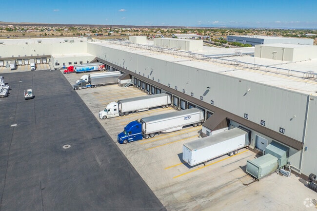
601 Ben E Keith Way Nw
Albuquerque, NM
LT 1A1 PLAT OF LOTS 1-A-1 AND 8-A UNSER TOWNE CROSSING CONT 50.9552 +/- AC
1-010-058-078148-3-05-01
Bernalillo
Coldstorage
New Mexico
B and X Area of moderate flood hazard, usually the area between the limits of the 100-year and 500-year floods.
1a
0
50.96 AC
2025
West Mesa
004760
Albuquerque
256,918 SF
NEARBY LISTINGS FOR SALE OR LEASE
DEMOGRAPHICS near 601 Ben E Keith Way Nw
1 mile
3 mile
5 mile
2025 Total Population
12,243
89,211
192,043
2030 Population
11,918
87,766
189,915
Pop Growth 2025-2030
(2.65%)
(1.62%)
(1.11%)
Average Age
36
38
39
2025 Total Households
4,490
32,238
72,548
HH Growth 2025-2030
(2.78%)
(1.71%)
(1.14%)
Median Household Inc
$65,833
$66,376
$64,968
Avg Household Size
2.70
2.70
2.50
2025 Avg HH Vehicles
2.00
2.00
2.00
Median Home Value
$260,337
$249,358
$258,571
Median Year Built
1997
1992
1989
Nearby Places
Map Layers
Map Styles
 Street
 Aerial
Layers
 Traffic
 Biking
Places
Listings with unknown addresses are not visible on the map
- Restaurants
- Banks
- Shops
- Fitness
- Groceries
PUBLIC TRANSPORTATION
COMMUTER RAIL
Downtown Albuquerque Rail Runner Station (NMRX - Rio Metro Regional Transit District)
Drive
Walk
Distance
Downtown Albuquerque Rail Runner Station (NMRX - Rio Metro Regional Transit District)
13 min
7.7 mi
Bernalillo County Rail Runner Station (NMRX - Rio Metro Regional Transit District)
Drive
Walk
Distance
Bernalillo County Rail Runner Station (NMRX - Rio Metro Regional Transit District)
18 min
9.3 mi
AIRPORT
Albuquerque International Sunport
Drive
Walk
Distance
Albuquerque International Sunport
31 min
16.8 mi
Freight Ports
Port of San Diego
Drive
Walk
Distance
Port of San Diego
855 min
804.9 mi
Nearby Properties
Address
Land Use
TOTAL SIZE
Lot Size
Zoning
Address
Land Use
TOTAL SIZE
Lot Size
Zoning
312,090 SF
35 AC
Address
Land Use
TOTAL SIZE
Lot Size
Zoning
Address
Land Use
TOTAL SIZE
Lot Size
Zoning
196,154 SF
14.81 AC
Address
Land Use
TOTAL SIZE
Lot Size
Zoning
20.08 AC
Address
Land Use
TOTAL SIZE
Lot Size
Zoning
Address
Land Use
TOTAL SIZE
Lot Size
Zoning
22,368 SF
13.64 AC
Address
Land Use
TOTAL SIZE
Lot Size
Zoning
63,424 SF
9.98 AC
Address
Land Use
TOTAL SIZE
Lot Size
Zoning
221,245 SF
18.23 AC
Address
Land Use
TOTAL SIZE
Lot Size
Zoning
16.59 AC
Address
Land Use
TOTAL SIZE
Lot Size
Zoning
Address
Land Use
TOTAL SIZE
Lot Size
Zoning
45,207 SF
9.08 AC
Address
Land Use
TOTAL SIZE
Lot Size
Zoning
60,636 SF
8.93 AC
Address
Land Use
TOTAL SIZE
Lot Size
Zoning
7,382 SF
12.35 AC
Address
Land Use
TOTAL SIZE
Lot Size
Zoning
182,708 SF
23.14 AC
Address
Land Use
TOTAL SIZE
Lot Size
Zoning
151,848 SF
9.69 AC
Address
Land Use
TOTAL SIZE
Lot Size
Zoning
202,223 SF
10.57 AC
Address
Land Use
TOTAL SIZE
Lot Size
Zoning
202,320 SF
15.12 AC
Address
Land Use
TOTAL SIZE
Lot Size
Zoning
16,072 SF
16.30 AC
Address
Land Use
TOTAL SIZE
Lot Size
Zoning
215,568 SF
10.99 AC
Address
Land Use
TOTAL SIZE
Lot Size
Zoning
130,082 SF
20 AC
Address
Land Use
TOTAL SIZE
Lot Size
Zoning
140,180 SF
3.23 AC
Address
Land Use
TOTAL SIZE
Lot Size
Zoning
Address
Land Use
TOTAL SIZE
Lot Size
Zoning
8,992 SF
16.48 AC
Address
Land Use
TOTAL SIZE
Lot Size
Zoning
91,318 SF
20.96 AC
Address
Land Use
TOTAL SIZE
Lot Size
Zoning
111,384 SF
9.99 AC
Address
Land Use
TOTAL SIZE
Lot Size
Zoning
242.71 AC
Address
Land Use
TOTAL SIZE
Lot Size
Zoning
123,236 SF
3.80 AC
Address
Land Use
TOTAL SIZE
Lot Size
Zoning
The World's #1 Commercial Real Estate Marketplace
Connect with us
© 2026 CoStar Group
The information above has been obtained from sources believed reliable. While we do not doubt its accuracy we have not verified it and make no guarantee, warranty or representation about it. It is your responsibility to independently confirm its accuracy and completeness. Any projections, opinions, assumptions, or estimates used are for example only and do not represent the current or future performance of the property. The value of this transaction to you depends on tax and other factors which should be evaluated by your tax, financial, and legal advisors. You and your advisors should conduct a careful, independent investigation of the property to determine to your satisfaction the suitability of the property for your needs.