Property Record
601 River Rd, Bridgeport, PA 19405


NEARBY LISTINGS FOR SALE OR LEASE
Property Detail
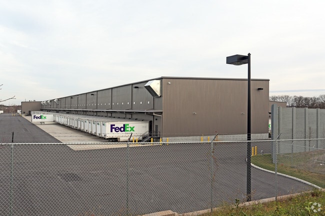
601 River Rd
Philadelphia-Camden-Wilmington, PA-NJ-DE-MD
Fedex Ground Distribution Faci
58-00-16521-044
ASSESSOR BLOCK-UNIT NUMBER 58-32
Truckterminal
Montgomery
A
Pennsylvania
42029C0120G
2
2024
55.48 AC
2025
East Montgomery Cty
205906
Philadelphia
310,900 SF
DEMOGRAPHICS near 601 River Rd
1 Mile
3 Mile
5 Mile
2024 Total Population
4,401
96,805
209,972
2029 Population
4,444
98,620
214,051
Pop Growth 2024-2029
+ 0.98%
+ 1.87%
+ 1.94%
Average Age
37
38
40
2024 Total Households
1,774
38,302
82,282
HH Growth 2024-2029
+ 0.90%
+ 1.97%
+ 2.09%
Median Household Inc
$90,737
$87,430
$101,292
Avg Household Size
2.40
2.40
2.40
2024 Avg HH Vehicles
2.00
2.00
2.00
Median Home Value
$272,011
$342,383
$398,430
Median Year Built
1958
1960
1967
Nearby Places
Map Layers
Map Styles
 Street
 Aerial
- Restaurants
- Banks
- Shops
- Fitness
- Groceries
PUBLIC TRANSPORTATION
COMMUTER RAIL
Norristown Transportation Center (R6 Line) (Manayunk/Norristown Line - SEPTA, R6 - SEPTA)
DRIVE
WALK
Distance
Norristown Transportation Center (R6 Line) (Manayunk/Norristown Line - SEPTA, R6 - SEPTA)
8 min
2.6 mi
Conshohocken (Manayunk/Norristown Line - SEPTA)
DRIVE
WALK
Distance
Conshohocken (Manayunk/Norristown Line - SEPTA)
7 min
2.7 mi
AIRPORT
Philadelphia International
DRIVE
WALK
Distance
Philadelphia International
40 min
25.3 mi
Freight Ports
Port of Philadelphia
DRIVE
WALK
Distance
Port of Philadelphia
33 min
20.7 mi
Nearby Properties
Address
Land Use
TOTAL SIZE
Lot Size
Zoning
Address
Land Use
TOTAL SIZE
Lot Size
Zoning
679,715 SF
58.23 AC
R2
Address
Land Use
TOTAL SIZE
Lot Size
Zoning
1,724,092 SF
24 AC
SC
Address
Land Use
TOTAL SIZE
Lot Size
Zoning
520,066 SF
1.02 AC
HB
Address
Land Use
TOTAL SIZE
Lot Size
Zoning
723,623 SF
6.69 AC
HVY
Address
Land Use
TOTAL SIZE
Lot Size
Zoning
469,066 SF
47 AC
MU
Address
Land Use
TOTAL SIZE
Lot Size
Zoning
527,618 SF
7.89 AC
SP2
Address
Land Use
TOTAL SIZE
Lot Size
Zoning
622,736 SF
2.06 AC
O
Address
Land Use
TOTAL SIZE
Lot Size
Zoning
676,867 SF
2.98 AC
SP2
Address
Land Use
TOTAL SIZE
Lot Size
Zoning
470,032 SF
2.98 AC
SP2
Address
Land Use
TOTAL SIZE
Lot Size
Zoning
434,229 SF
3.24 AC
HI
Address
Land Use
TOTAL SIZE
Lot Size
Zoning
872,232 SF
51.99 AC
G
Address
Land Use
TOTAL SIZE
Lot Size
Zoning
426,711 SF
6.04 AC
HI
Address
Land Use
TOTAL SIZE
Lot Size
Zoning
843,567 SF
50.79 AC
HI
Address
Land Use
TOTAL SIZE
Lot Size
Zoning
214,714 SF
22.23 AC
R1
Address
Land Use
TOTAL SIZE
Lot Size
Zoning
197,108 SF
2.08 AC
SC
Address
Land Use
TOTAL SIZE
Lot Size
Zoning
531,656 SF
19.51 AC
HVY
Address
Land Use
TOTAL SIZE
Lot Size
Zoning
660,582 SF
5.43 AC
O
Address
Land Use
TOTAL SIZE
Lot Size
Zoning
231,665 SF
26.34 AC
OSR
Address
Land Use
TOTAL SIZE
Lot Size
Zoning
804,184 SF
26.72 AC
HR
Address
Land Use
TOTAL SIZE
Lot Size
Zoning
370,404 SF
15.55 AC
SM1
Address
Land Use
TOTAL SIZE
Lot Size
Zoning
114,121 SF
16.80 AC
LI
Address
Land Use
TOTAL SIZE
Lot Size
Zoning
961,106 SF
5.47 AC
LI
Address
Land Use
TOTAL SIZE
Lot Size
Zoning
452,740 SF
11.03 AC
C
Address
Land Use
TOTAL SIZE
Lot Size
Zoning
610,819 SF
3.17 AC
O1
Address
Land Use
TOTAL SIZE
Lot Size
Zoning
10.44 AC
HI
Address
Land Use
TOTAL SIZE
Lot Size
Zoning
320,804 SF
30.85 AC
CR
Address
Land Use
TOTAL SIZE
Lot Size
Zoning
368,147 SF
3.70 AC
O1
Address
Land Use
TOTAL SIZE
Lot Size
Zoning
312,710 SF
30.07 AC
APTLR
Address
Land Use
TOTAL SIZE
Lot Size
Zoning
346,163 SF
16.53 AC
SC
The World's #1 Commercial Real Estate Marketplace
Connect with us
© 2025 CoStar Group
The information above has been obtained from sources believed reliable. While we do not doubt its accuracy we have not verified it and make no guarantee, warranty or representation about it. It is your responsibility to independently confirm its accuracy and completeness. Any projections, opinions, assumptions, or estimates used are for example only and do not represent the current or future performance of the property. The value of this transaction to you depends on tax and other factors which should be evaluated by your tax, financial, and legal advisors. You and your advisors should conduct a careful, independent investigation of the property to determine to your satisfaction the suitability of the property for your needs.