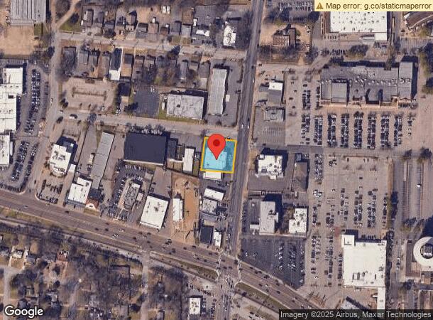
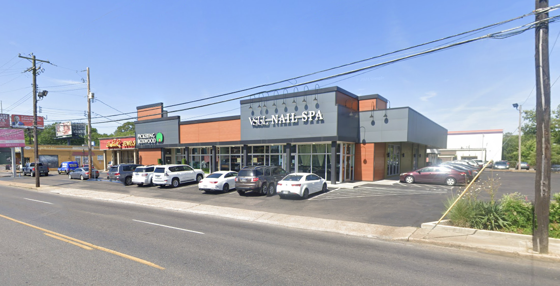
Property Record
601 S Mendenhall Rd, Memphis, TN 38117

NEARBY LISTINGS FOR SALE OR LEASE
Property Detail
601 S Mendenhall Rd
Memphis, TN-MS-AR
William Arnold Estate
05-6008-0-0097
WS NORTH MENDENHALL RD COR BLACK RD SW
Storebuilding
Shelby
X
Tennessee
47157C0435F
50-52
2023
0.48 AC
2024
East
008500
Memphis
7,959 SF
DEMOGRAPHICS near 601 S Mendenhall Rd
1 Mile
3 Mile
5 Mile
2024 Total Population
6,857
72,789
235,508
2029 Population
6,676
71,206
232,713
Pop Growth 2024-2029
(2.64%)
(2.17%)
(1.19%)
Average Age
44
39
37
2024 Total Households
3,293
31,139
94,990
HH Growth 2024-2029
(2.79%)
(2.29%)
(1.29%)
Median Household Inc
$86,613
$68,887
$49,410
Avg Household Size
2.10
2.30
2.40
2024 Avg HH Vehicles
2.00
2.00
2.00
Median Home Value
$354,268
$285,161
$207,726
Median Year Built
1962
1959
1967
Nearby Places
- Restaurants
- Banks
- Shops
- Fitness
- Groceries
PUBLIC TRANSPORTATION
AIRPORT
Memphis International
DRIVE
WALK
Distance
Memphis International
16 min
10.5 mi
Freight Ports
Port of Shreveport
DRIVE
WALK
Distance
Port of Shreveport
414 min
377.4 mi
SALE & LEASE HISTORY
LISTING DATE
SALE/LEASE

Jan 04, 2017
For Lease
Nearby Properties
Address
Land Use
TOTAL SIZE
Lot Size
Zoning
Address
Land Use
TOTAL SIZE
Lot Size
Zoning
209,070 SF
5.10 AC
RU-3
Address
Land Use
TOTAL SIZE
Lot Size
Zoning
253,002 SF
2.82 AC
CA
Address
Land Use
TOTAL SIZE
Lot Size
Zoning
290,566 SF
2.51 AC
R-15
Address
Land Use
TOTAL SIZE
Lot Size
Zoning
358,595 SF
3.65 AC
R-15
Address
Land Use
TOTAL SIZE
Lot Size
Zoning
85,062 SF
8.43 AC
CA
Address
Land Use
TOTAL SIZE
Lot Size
Zoning
104,337 SF
7.30 AC
R-15
Address
Land Use
TOTAL SIZE
Lot Size
Zoning
101,654 SF
6.61 AC
R-15
Address
Land Use
TOTAL SIZE
Lot Size
Zoning
189,536 SF
49.14 AC
CMU-2
Address
Land Use
TOTAL SIZE
Lot Size
Zoning
1,082,619 SF
34.67 AC
CMP-1
Address
Land Use
TOTAL SIZE
Lot Size
Zoning
657,276 SF
10.18 AC
OG
Address
Land Use
TOTAL SIZE
Lot Size
Zoning
190,263 SF
6.59 AC
R-10
Address
Land Use
TOTAL SIZE
Lot Size
Zoning
2,505 SF
52.59 AC
R-10
Address
Land Use
TOTAL SIZE
Lot Size
Zoning
45.85 AC
CA
Address
Land Use
TOTAL SIZE
Lot Size
Zoning
123,976 SF
10.31 AC
CMU-3
Address
Land Use
TOTAL SIZE
Lot Size
Zoning
269,022 SF
23.76 AC
RU-3
Address
Land Use
TOTAL SIZE
Lot Size
Zoning
24.72 AC
R-10
Address
Land Use
TOTAL SIZE
Lot Size
Zoning
63,114 SF
7.13 AC
CA
Address
Land Use
TOTAL SIZE
Lot Size
Zoning
71,673 SF
1.49 AC
OG
Address
Land Use
TOTAL SIZE
Lot Size
Zoning
347,228 SF
3.56 AC
R-15
Address
Land Use
TOTAL SIZE
Lot Size
Zoning
118,073 SF
4.75 AC
CMU-1
Address
Land Use
TOTAL SIZE
Lot Size
Zoning
99,554 SF
3.26 AC
R-15
Address
Land Use
TOTAL SIZE
Lot Size
Zoning
46,216 SF
2.71 AC
CMU-3
Address
Land Use
TOTAL SIZE
Lot Size
Zoning
4,744 SF
19.65 AC
R-15
Address
Land Use
TOTAL SIZE
Lot Size
Zoning
96,768 SF
7.98 AC
OG
Address
Land Use
TOTAL SIZE
Lot Size
Zoning
113,826 SF
29.01 AC
RU-3
Address
Land Use
TOTAL SIZE
Lot Size
Zoning
261,479 SF
5.50 AC
RU-3
Address
Land Use
TOTAL SIZE
Lot Size
Zoning
104.22 AC
R-15
Address
Land Use
TOTAL SIZE
Lot Size
Zoning
130,111 SF
5.95 AC
R-15
Address
Land Use
TOTAL SIZE
Lot Size
Zoning
100,182 SF
9.39 AC
CMU-3
Address
Land Use
TOTAL SIZE
Lot Size
Zoning
28.04 AC
R-10
The World's #1 Commercial Real Estate Marketplace
Connect with us
© 2025 CoStar Group
The information above has been obtained from sources believed reliable. While we do not doubt its accuracy we have not verified it and make no guarantee, warranty or representation about it. It is your responsibility to independently confirm its accuracy and completeness. Any projections, opinions, assumptions, or estimates used are for example only and do not represent the current or future performance of the property. The value of this transaction to you depends on tax and other factors which should be evaluated by your tax, financial, and legal advisors. You and your advisors should conduct a careful, independent investigation of the property to determine to your satisfaction the suitability of the property for your needs.