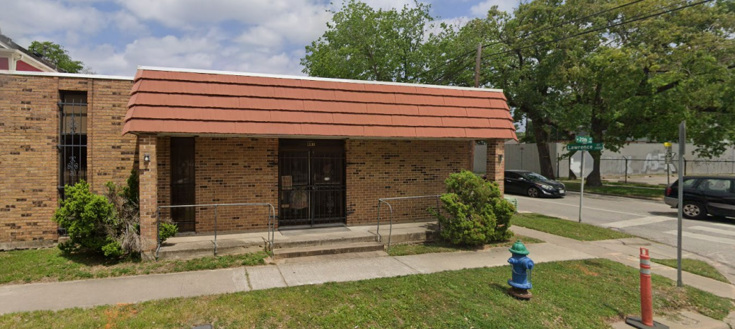
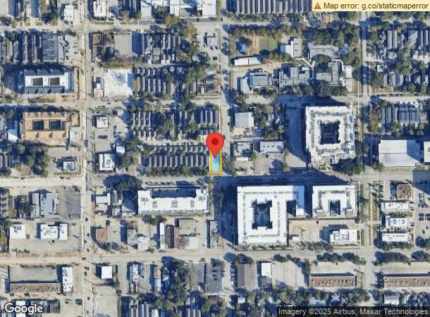
Property Record
601 W 20Th St, Houston, TX 77008
NEARBY LISTINGS FOR SALE OR LEASE
Property Detail
601 W 20Th St
Houston-The Woodlands-Sugar Land, TX
Houston Heights
0200780000047
LTS 47 & 48 BLK 82 HOUSTON HEIGHTS
Officebuilding
Harris
X
Texas
48201C0670M
47,48
0
0.15 AC
2023
North Loop West
511501
Houston
3,479 SF
DEMOGRAPHICS near 601 W 20Th St
1 Mile
3 Mile
5 Mile
2024 Total Population
23,166
170,720
454,505
2029 Population
24,213
178,336
472,150
Pop Growth 2024-2029
+ 4.52%
+ 4.46%
+ 3.88%
Average Age
37
37
38
2024 Total Households
10,999
78,591
199,513
HH Growth 2024-2029
+ 4.49%
+ 4.54%
+ 4.16%
Median Household Inc
$156,204
$103,793
$78,949
Avg Household Size
2.10
2.10
2.20
2024 Avg HH Vehicles
2.00
2.00
2.00
Median Home Value
$484,999
$457,199
$416,821
Median Year Built
2005
1999
1991
Nearby Places
- Restaurants
- Banks
- Shops
- Fitness
- Groceries
PUBLIC TRANSPORTATION
COMMUTER RAIL
Houston (Sunset Limited - Amtrak)
DRIVE
WALK
Distance
Houston (Sunset Limited - Amtrak)
9 min
4.5 mi
AIRPORT
William P Hobby
DRIVE
WALK
Distance
William P Hobby
30 min
17.4 mi
George Bush Intcntl/Houston
DRIVE
WALK
Distance
George Bush Intcntl/Houston
24 min
19.3 mi
Freight Ports
Port of Houston
DRIVE
WALK
Distance
Port of Houston
22 min
14.5 mi
SALE & LEASE HISTORY
LISTING DATE
SALE/LEASE

Feb 27, 2024
For Sale
Nearby Properties
Address
Land Use
TOTAL SIZE
Lot Size
Zoning
Address
Land Use
TOTAL SIZE
Lot Size
Zoning
453,456 SF
3.11 AC
Address
Land Use
TOTAL SIZE
Lot Size
Zoning
432,689 SF
2.84 AC
Address
Land Use
TOTAL SIZE
Lot Size
Zoning
519,374 SF
6.18 AC
Address
Land Use
TOTAL SIZE
Lot Size
Zoning
308,055 SF
2.22 AC
Address
Land Use
TOTAL SIZE
Lot Size
Zoning
788,433 SF
5.09 AC
Address
Land Use
TOTAL SIZE
Lot Size
Zoning
591,997 SF
4.83 AC
Address
Land Use
TOTAL SIZE
Lot Size
Zoning
314,489 SF
1.84 AC
Address
Land Use
TOTAL SIZE
Lot Size
Zoning
416,975 SF
2.52 AC
Address
Land Use
TOTAL SIZE
Lot Size
Zoning
538,026 SF
7.03 AC
Address
Land Use
TOTAL SIZE
Lot Size
Zoning
641,392 SF
10 AC
Address
Land Use
TOTAL SIZE
Lot Size
Zoning
457,647 SF
2.30 AC
Address
Land Use
TOTAL SIZE
Lot Size
Zoning
641,684 SF
3.30 AC
Address
Land Use
TOTAL SIZE
Lot Size
Zoning
684,371 SF
3.97 AC
Address
Land Use
TOTAL SIZE
Lot Size
Zoning
675,412 SF
10.09 AC
Address
Land Use
TOTAL SIZE
Lot Size
Zoning
445,191 SF
3.58 AC
Address
Land Use
TOTAL SIZE
Lot Size
Zoning
324,709 SF
4 AC
Address
Land Use
TOTAL SIZE
Lot Size
Zoning
443,982 SF
3.79 AC
Address
Land Use
TOTAL SIZE
Lot Size
Zoning
315,439 SF
3.54 AC
Address
Land Use
TOTAL SIZE
Lot Size
Zoning
286,717 SF
1.90 AC
Address
Land Use
TOTAL SIZE
Lot Size
Zoning
456,974 SF
43.16 AC
Address
Land Use
TOTAL SIZE
Lot Size
Zoning
264,101 SF
3.58 AC
Address
Land Use
TOTAL SIZE
Lot Size
Zoning
261,312 SF
1.81 AC
Address
Land Use
TOTAL SIZE
Lot Size
Zoning
477,064 SF
4.76 AC
Address
Land Use
TOTAL SIZE
Lot Size
Zoning
721,788 SF
10.14 AC
Address
Land Use
TOTAL SIZE
Lot Size
Zoning
255,545 SF
2.91 AC
Address
Land Use
TOTAL SIZE
Lot Size
Zoning
366,386 SF
10.85 AC
Address
Land Use
TOTAL SIZE
Lot Size
Zoning
295,572 SF
3.05 AC
Address
Land Use
TOTAL SIZE
Lot Size
Zoning
683,861 SF
15.03 AC
Address
Land Use
TOTAL SIZE
Lot Size
Zoning
490,455 SF
4.91 AC
Address
Land Use
TOTAL SIZE
Lot Size
Zoning
379,725 SF
2.84 AC
The World's #1 Commercial Real Estate Marketplace
Connect with us
© 2025 CoStar Group
The information above has been obtained from sources believed reliable. While we do not doubt its accuracy we have not verified it and make no guarantee, warranty or representation about it. It is your responsibility to independently confirm its accuracy and completeness. Any projections, opinions, assumptions, or estimates used are for example only and do not represent the current or future performance of the property. The value of this transaction to you depends on tax and other factors which should be evaluated by your tax, financial, and legal advisors. You and your advisors should conduct a careful, independent investigation of the property to determine to your satisfaction the suitability of the property for your needs.