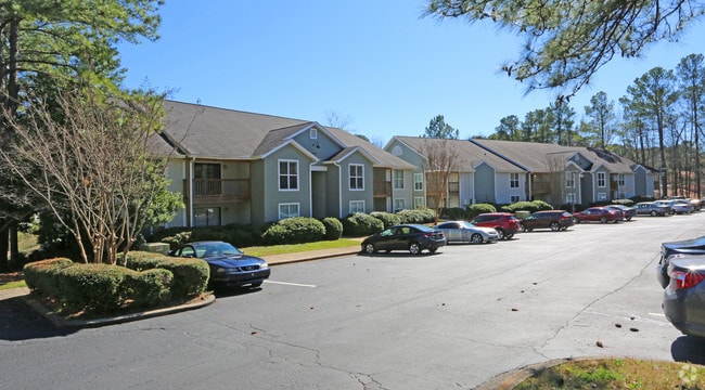
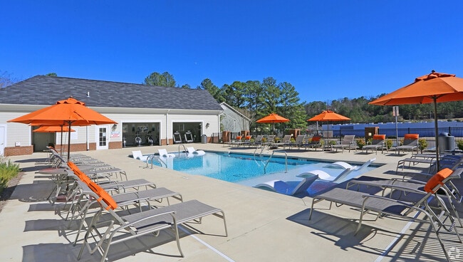
Property Record
6010 Wisteria Dr, Birmingham, AL 35210
NEARBY LISTINGS FOR SALE OR LEASE
-
-
View all Birmingham listings for sale on LoopNet.com
Property Detail
6010 Wisteria Dr
Birmingham-Hoover, AL
Irondale Park Sub
23-00-25-1-001-001.002
BEG INTER OF NWLY R/W L OF BEACON DR NELY COR OF LOT 2 IRONDALE PARK SUB PB 134 PG 52 TH NELY ALG SD R/W L 350 FT TH NWLY 533.5 FT TH SWLY 570.1 FT TH SLY 156.1 FT TH 383 FT SELY TH SE 144 FT TH NE 102 FT TH SELY 241.5 FT TO POB
Apartment
Jefferson
X
Alabama
01073C0414H
2
2023
7.30 AC
2024
Outlying Jefferson County
012701
Birmingham
73,896 SF
DEMOGRAPHICS near 6010 Wisteria Dr
1 Mile
3 Mile
5 Mile
2024 Total Population
4,576
38,920
91,579
2029 Population
4,451
38,393
90,055
Pop Growth 2024-2029
(2.73%)
(1.35%)
(1.66%)
Average Age
41
40
39
2024 Total Households
2,027
16,158
37,496
HH Growth 2024-2029
(2.76%)
(1.56%)
(1.79%)
Median Household Inc
$65,737
$56,457
$62,905
Avg Household Size
2.20
2.20
2.30
2024 Avg HH Vehicles
2.00
2.00
2.00
Median Home Value
$171,572
$212,585
$281,995
Median Year Built
1973
1968
1968
Nearby Places
Map Layers
Map Styles
 Street
 Aerial
- Restaurants
- Banks
- Shops
- Fitness
- Groceries
PUBLIC TRANSPORTATION
COMMUTER RAIL
DRIVE
WALK
Distance
13 min
7.5 mi
AIRPORT
Birmingham-Shuttlesworth International
DRIVE
WALK
Distance
Birmingham-Shuttlesworth International
10 min
5.6 mi
Nearby Properties
Address
Land Use
TOTAL SIZE
Lot Size
Zoning
Address
Land Use
TOTAL SIZE
Lot Size
Zoning
166,863 SF
21 AC
CB2
Address
Land Use
TOTAL SIZE
Lot Size
Zoning
80,288 SF
2.91 AC
CB2
Address
Land Use
TOTAL SIZE
Lot Size
Zoning
423,995 SF
25 AC
R3
Address
Land Use
TOTAL SIZE
Lot Size
Zoning
144,135 SF
31.95 AC
CR5
Address
Land Use
TOTAL SIZE
Lot Size
Zoning
158,161 SF
15.48 AC
C1
Address
Land Use
TOTAL SIZE
Lot Size
Zoning
125,324 SF
53 AC
INST
Address
Land Use
TOTAL SIZE
Lot Size
Zoning
137,168 SF
63 AC
A1
Address
Land Use
TOTAL SIZE
Lot Size
Zoning
297,391 SF
27.10 AC
CR5
Address
Land Use
TOTAL SIZE
Lot Size
Zoning
131,319 SF
13.28 AC
CB2
Address
Land Use
TOTAL SIZE
Lot Size
Zoning
235,552 SF
10.13 AC
R3
Address
Land Use
TOTAL SIZE
Lot Size
Zoning
168,744 SF
8.46 AC
I1
Address
Land Use
TOTAL SIZE
Lot Size
Zoning
83,776 SF
3.79 AC
B6
Address
Land Use
TOTAL SIZE
Lot Size
Zoning
22 AC
CB2
Address
Land Use
TOTAL SIZE
Lot Size
Zoning
210,920 SF
22.41 AC
CB2
Address
Land Use
TOTAL SIZE
Lot Size
Zoning
145,949 SF
10.01 AC
QR6
Address
Land Use
TOTAL SIZE
Lot Size
Zoning
102,748 SF
8.50 AC
CB2
Address
Land Use
TOTAL SIZE
Lot Size
Zoning
8.10 AC
QR6
Address
Land Use
TOTAL SIZE
Lot Size
Zoning
223,365 SF
15 AC
I1
Address
Land Use
TOTAL SIZE
Lot Size
Zoning
43,566 SF
18.99 AC
C1
Address
Land Use
TOTAL SIZE
Lot Size
Zoning
150,750 SF
12.60 AC
CR5
Address
Land Use
TOTAL SIZE
Lot Size
Zoning
52,416 SF
7 AC
A1
Address
Land Use
TOTAL SIZE
Lot Size
Zoning
301,531 SF
41 AC
B5
Address
Land Use
TOTAL SIZE
Lot Size
Zoning
93,300 SF
29 AC
R3
Address
Land Use
TOTAL SIZE
Lot Size
Zoning
188,160 SF
14 AC
CB2
Address
Land Use
TOTAL SIZE
Lot Size
Zoning
113,014 SF
8 AC
I1
Address
Land Use
TOTAL SIZE
Lot Size
Zoning
104,000 SF
7.66 AC
I1
Address
Land Use
TOTAL SIZE
Lot Size
Zoning
47,720 SF
5.21 AC
QB2
Address
Land Use
TOTAL SIZE
Lot Size
Zoning
97,021 SF
17.50 AC
R1
Address
Land Use
TOTAL SIZE
Lot Size
Zoning
63,798 SF
4.18 AC
I1
Address
Land Use
TOTAL SIZE
Lot Size
Zoning
119,300 SF
7.72 AC
I1
The World's #1 Commercial Real Estate Marketplace
Connect with us
© 2026 CoStar Group
The information above has been obtained from sources believed reliable. While we do not doubt its accuracy we have not verified it and make no guarantee, warranty or representation about it. It is your responsibility to independently confirm its accuracy and completeness. Any projections, opinions, assumptions, or estimates used are for example only and do not represent the current or future performance of the property. The value of this transaction to you depends on tax and other factors which should be evaluated by your tax, financial, and legal advisors. You and your advisors should conduct a careful, independent investigation of the property to determine to your satisfaction the suitability of the property for your needs.