Property Record
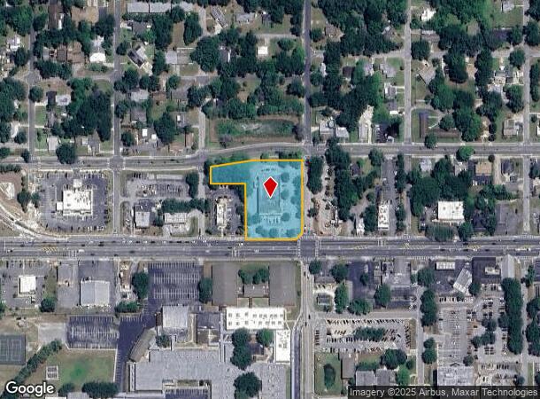
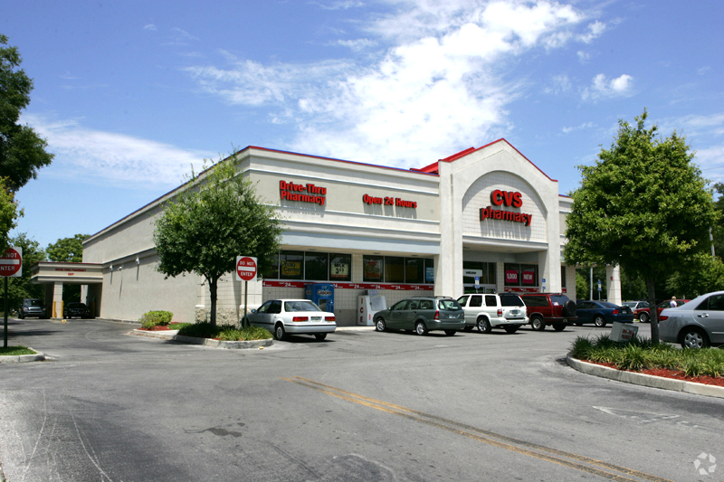
602 W Main St, Inverness, FL 34450

NEARBY LISTINGS FOR SALE OR LEASE
Property Detail
602 W Main St
Homosassa Springs, FL
Tomkinsville Add To Inverness
20E-19S-18-0010-00000-0010
TOMPKINSVILLE ADD TO INVERNESS PB 1 PG 36 COM AT A CONCRETE MONUMENT FOUND AT THE INTERSECTION OF THE W R/W LN OF N LINE AVE AND THE S R/W LN OF TOMPKINS ST IN THE CITY OF INVERNESS FL. SD CONCRETE MONUMENT ALSO BEING LOCATED AT THE NE COR OF LOT A P
Storemultistory
Citrus
X
Florida
12017C0354D
a
2023
1.76 AC
2024
Florida Central North Area
450902
Other Market Areas
11,200 SF
DEMOGRAPHICS near 602 W Main St
1 Mile
3 Mile
5 Mile
2024 Total Population
3,012
19,114
34,956
2029 Population
3,403
21,661
39,622
Pop Growth 2024-2029
+ 12.98%
+ 13.33%
+ 13.35%
Average Age
49
48
48
2024 Total Households
1,388
8,578
15,756
HH Growth 2024-2029
+ 12.82%
+ 13.15%
+ 13.16%
Median Household Inc
$38,965
$38,797
$40,595
Avg Household Size
2.00
2.10
2.10
2024 Avg HH Vehicles
1.00
2.00
2.00
Median Home Value
$182,882
$165,662
$167,135
Median Year Built
1984
1984
1984
Nearby Places
- Restaurants
- Banks
- Shops
- Fitness
- Groceries
SALE & LEASE HISTORY
LISTING DATE
SALE/LEASE

Sep 23, 2016
For Sale
May 02, 2017
For Sale
Jun 08, 2017
For Sale
Nearby Properties
Address
Land Use
TOTAL SIZE
Lot Size
Zoning
Address
Land Use
TOTAL SIZE
Lot Size
Zoning
7,138,137 SF
12.68 AC
PSP
Address
Land Use
TOTAL SIZE
Lot Size
Zoning
151,398 SF
51.27 AC
PSP
Address
Land Use
TOTAL SIZE
Lot Size
Zoning
40,730 SF
35.79 AC
PSP
Address
Land Use
TOTAL SIZE
Lot Size
Zoning
103,592 SF
1.12 AC
CBD
Address
Land Use
TOTAL SIZE
Lot Size
Zoning
151,168 SF
16.38 AC
PSP
Address
Land Use
TOTAL SIZE
Lot Size
Zoning
36,756 SF
22.06 AC
PSP
Address
Land Use
TOTAL SIZE
Lot Size
Zoning
139,076 SF
6.12 AC
C
Address
Land Use
TOTAL SIZE
Lot Size
Zoning
89,638 SF
21.78 AC
PSP
Address
Land Use
TOTAL SIZE
Lot Size
Zoning
106,366 SF
45.53 AC
PSP
Address
Land Use
TOTAL SIZE
Lot Size
Zoning
83,966 SF
29.08 AC
PSP
Address
Land Use
TOTAL SIZE
Lot Size
Zoning
2,251,312 SF
13.80 AC
C
Address
Land Use
TOTAL SIZE
Lot Size
Zoning
75,976 SF
229.96 AC
TCU
Address
Land Use
TOTAL SIZE
Lot Size
Zoning
53,746 SF
13.98 AC
PSP
Address
Land Use
TOTAL SIZE
Lot Size
Zoning
155,103 SF
3.90 AC
PSP
Address
Land Use
TOTAL SIZE
Lot Size
Zoning
146,480 SF
2.27 AC
CBD
Address
Land Use
TOTAL SIZE
Lot Size
Zoning
61,778 SF
1.54 AC
CBD
Address
Land Use
TOTAL SIZE
Lot Size
Zoning
162,123 SF
10.82 AC
C
Address
Land Use
TOTAL SIZE
Lot Size
Zoning
157,116 SF
4.37 AC
PSP
Address
Land Use
TOTAL SIZE
Lot Size
Zoning
44,260 SF
3.92 AC
RO
Address
Land Use
TOTAL SIZE
Lot Size
Zoning
91,826 SF
19.74 AC
RO
Address
Land Use
TOTAL SIZE
Lot Size
Zoning
106,908 SF
19.69 AC
LDRMH
Address
Land Use
TOTAL SIZE
Lot Size
Zoning
26,391 SF
5.06 AC
LD
Address
Land Use
TOTAL SIZE
Lot Size
Zoning
68,720 SF
1.01 AC
CBD
Address
Land Use
TOTAL SIZE
Lot Size
Zoning
37,800 SF
5.15 AC
PSP
Address
Land Use
TOTAL SIZE
Lot Size
Zoning
16,448 SF
1.61 AC
CBD
Address
Land Use
TOTAL SIZE
Lot Size
Zoning
31,322 SF
7.35 AC
ULD
Address
Land Use
TOTAL SIZE
Lot Size
Zoning
576,868 SF
8.63 AC
MD
Address
Land Use
TOTAL SIZE
Lot Size
Zoning
22,316 SF
1.10 AC
CBD
Address
Land Use
TOTAL SIZE
Lot Size
Zoning
71,113 SF
4.51 AC
C
The World's #1 Commercial Real Estate Marketplace
Connect with us
© 2025 CoStar Group
The information above has been obtained from sources believed reliable. While we do not doubt its accuracy we have not verified it and make no guarantee, warranty or representation about it. It is your responsibility to independently confirm its accuracy and completeness. Any projections, opinions, assumptions, or estimates used are for example only and do not represent the current or future performance of the property. The value of this transaction to you depends on tax and other factors which should be evaluated by your tax, financial, and legal advisors. You and your advisors should conduct a careful, independent investigation of the property to determine to your satisfaction the suitability of the property for your needs.