Property Record
6045 Hazelhurst Pl, North Hollywood, CA 91606


Property Detail
6045 Hazelhurst Pl
2334-014-056
TRACT # 6516 THAT PART E OF A LINE PARALLEL WITH AND DIST NE AT R/A 15 FT FROM SW LINE OF LOT 22
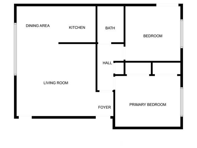
Multifamilydwelling
Los Angeles
LAR3
California
B and X Area of moderate flood hazard, usually the area between the limits of the 100-year and 500-year floods.
22
2025
0.36 AC
2025
North Hollywood
124105
Los Angeles
8,476 SF
Los Angeles-Long Beach-Glendale, CA
NEARBY LISTINGS FOR SALE OR LEASE
DEMOGRAPHICS near 6045 Hazelhurst Pl
1 mile
3 mile
5 mile
2025 Total Population
42,909
301,536
617,955
2030 Population
43,133
300,946
615,891
Pop Growth 2025-2030
+ 0.52%
(0.20%)
(0.33%)
Average Age
39
40
40
2025 Total Households
16,250
117,203
232,833
HH Growth 2025-2030
+ 0.31%
(0.37%)
(0.54%)
Median Household Inc
$69,644
$82,325
$85,619
Avg Household Size
2.50
2.50
2.60
2025 Avg HH Vehicles
2.00
2.00
2.00
Median Home Value
$915,152
$943,141
$960,322
Median Year Built
1965
1967
1967
Nearby Places
Map Layers
Map Styles
 Street
 Aerial
Layers
 Traffic
 Biking
Places
Listings with unknown addresses are not visible on the map
- Restaurants
- Banks
- Shops
- Fitness
- Groceries
PUBLIC TRANSPORTATION
TRANSIT/SUBWAY
North Hollywood Station (Orange Line - Los Angeles County Metropolitan Transportation Authority (Metro), Red Line - Los Angeles County Metropolitan Transportation Authority (Metro))
Drive
Walk
Distance
North Hollywood Station (Orange Line - Los Angeles County Metropolitan Transportation Authority (Metro), Red Line - Los Angeles County Metropolitan Transportation Authority (Metro))
2 min
20 min
1.1 mi
COMMUTER RAIL
Burbank-Bob Hope Airport (Ventura County Line - Southern California Regional Rail Authority (Metrolink))
Drive
Walk
Distance
Burbank-Bob Hope Airport (Ventura County Line - Southern California Regional Rail Authority (Metrolink))
6 min
3.1 mi
Burbank Airport - North (Av Line) Metrolink Station (Metrolink Antelope Valley Line - Metrolink Trains)
Drive
Walk
Distance
Burbank Airport - North (Av Line) Metrolink Station (Metrolink Antelope Valley Line - Metrolink Trains)
8 min
5.1 mi
AIRPORT
Bob Hope
Drive
Walk
Distance
Bob Hope
6 min
3.2 mi
Los Angeles International
Drive
Walk
Distance
Los Angeles International
34 min
23.8 mi
Long Beach (Daugherty Field)
Drive
Walk
Distance
Long Beach (Daugherty Field)
49 min
36.0 mi
Freight Ports
Port of Long Beach
Drive
Walk
Distance
Port of Long Beach
51 min
37.5 mi
SALE & LEASE HISTORY
LISTING DATE
SALE/LEASE

Jul 29, 2025
For Sale
Nearby Properties
Address
Land Use
TOTAL SIZE
Lot Size
Zoning
Address
Land Use
TOTAL SIZE
Lot Size
Zoning
518,067 SF
17.27 AC
LAC4
Address
Land Use
TOTAL SIZE
Lot Size
Zoning
690,600 SF
6.57 AC
LACM
Address
Land Use
TOTAL SIZE
Lot Size
Zoning
43,558 SF
30.11 AC
BUMI-C2*
Address
Land Use
TOTAL SIZE
Lot Size
Zoning
529,249 SF
5.42 AC
LAC4
Address
Land Use
TOTAL SIZE
Lot Size
Zoning
432,232 SF
7.17 AC
BUM2
Address
Land Use
TOTAL SIZE
Lot Size
Zoning
354,068 SF
2.72 AC
LAR4
Address
Land Use
TOTAL SIZE
Lot Size
Zoning
80,158 SF
37.04 AC
LAM2
Address
Land Use
TOTAL SIZE
Lot Size
Zoning
336,041 SF
2.05 AC
LAC4
Address
Land Use
TOTAL SIZE
Lot Size
Zoning
346,186 SF
11.72 AC
BUM2*
Address
Land Use
TOTAL SIZE
Lot Size
Zoning
380,276 SF
7.18 AC
LAR4
Address
Land Use
TOTAL SIZE
Lot Size
Zoning
232,965 SF
3.78 AC
LAC4
Address
Land Use
TOTAL SIZE
Lot Size
Zoning
388,171 SF
2.42 AC
LAC4
Address
Land Use
TOTAL SIZE
Lot Size
Zoning
283,018 SF
9.45 AC
LAMR2
Address
Land Use
TOTAL SIZE
Lot Size
Zoning
286,880 SF
2.58 AC
LARAS4
Address
Land Use
TOTAL SIZE
Lot Size
Zoning
182,061 SF
1.99 AC
LAC4
Address
Land Use
TOTAL SIZE
Lot Size
Zoning
227,746 SF
4.03 AC
LAC4
Address
Land Use
TOTAL SIZE
Lot Size
Zoning
152,445 SF
1.05 AC
LAC4
Address
Land Use
TOTAL SIZE
Lot Size
Zoning
279,574 SF
4.01 AC
BUM2*
Address
Land Use
TOTAL SIZE
Lot Size
Zoning
144,285 SF
1.72 AC
LAC2
Address
Land Use
TOTAL SIZE
Lot Size
Zoning
201,944 SF
1.14 AC
LAC4
Address
Land Use
TOTAL SIZE
Lot Size
Zoning
157,475 SF
2.10 AC
LAC2
Address
Land Use
TOTAL SIZE
Lot Size
Zoning
132,652 SF
0.76 AC
LAC2
Address
Land Use
TOTAL SIZE
Lot Size
Zoning
68,150 SF
13.88 AC
LARD1.5
Address
Land Use
TOTAL SIZE
Lot Size
Zoning
221,276 SF
1.37 AC
LAC4
Address
Land Use
TOTAL SIZE
Lot Size
Zoning
196,211 SF
2.01 AC
LAR4
Address
Land Use
TOTAL SIZE
Lot Size
Zoning
162,506 SF
2.28 AC
LAC2
Address
Land Use
TOTAL SIZE
Lot Size
Zoning
222,004 SF
2.29 AC
LAC4
Address
Land Use
TOTAL SIZE
Lot Size
Zoning
98,080 SF
4.30 AC
LAC1.5
Address
Land Use
TOTAL SIZE
Lot Size
Zoning
170,414 SF
1.46 AC
LAC4
The World's #1 Commercial Real Estate Marketplace
Connect with us
© 2026 CoStar Group
The information above has been obtained from sources believed reliable. While we do not doubt its accuracy we have not verified it and make no guarantee, warranty or representation about it. It is your responsibility to independently confirm its accuracy and completeness. Any projections, opinions, assumptions, or estimates used are for example only and do not represent the current or future performance of the property. The value of this transaction to you depends on tax and other factors which should be evaluated by your tax, financial, and legal advisors. You and your advisors should conduct a careful, independent investigation of the property to determine to your satisfaction the suitability of the property for your needs.