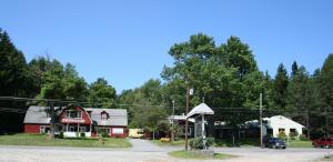
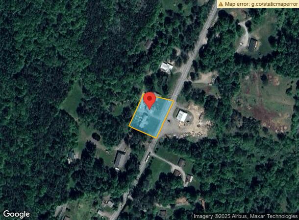
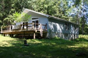
Property Record
607 S Sterling Rd, South Sterling, PA 18460
NEARBY LISTINGS FOR SALE OR LEASE
-
-
View all South Sterling listings for sale on LoopNet.com
Property Detail
607 S Sterling Rd
101798
LOT 66.4 SECTION 1 TRACT 1
Departmentstore
Wayne
X
Pennsylvania
42127C0462D
66.4
2023
1.04 AC
2023
Poconos & Stroudsburg
961300
Other Market Areas
4,248 SF
DEMOGRAPHICS near 607 S Sterling Rd
1 Mile
3 Mile
5 Mile
2024 Total Population
250
2,211
9,033
2029 Population
247
2,269
9,396
Pop Growth 2024-2029
(1.20%)
+ 2.62%
+ 4.02%
Average Age
46
46
44
2024 Total Households
108
952
3,610
HH Growth 2024-2029
(0.93%)
+ 2.31%
+ 3.88%
Median Household Inc
$42,500
$46,534
$54,227
Avg Household Size
2.20
2.20
2.40
2024 Avg HH Vehicles
2.00
2.00
2.00
Median Home Value
$236,000
$226,425
$172,920
Median Year Built
1981
1984
1987
Nearby Places
- Restaurants
- Banks
- Shops
- Fitness
- Groceries
PUBLIC TRANSPORTATION
AIRPORT
Wilkes-Barre/Scranton International
DRIVE
WALK
Distance
Wilkes-Barre/Scranton International
49 min
33.6 mi
Freight Ports
Maher Terminal
DRIVE
WALK
Distance
Maher Terminal
130 min
97.1 mi
Nearby Properties
Address
Land Use
TOTAL SIZE
Lot Size
Zoning
Address
Land Use
TOTAL SIZE
Lot Size
Zoning
2,703 SF
42.89 AC
Address
Land Use
TOTAL SIZE
Lot Size
Zoning
38.59 AC
Address
Land Use
TOTAL SIZE
Lot Size
Zoning
Address
Land Use
TOTAL SIZE
Lot Size
Zoning
224 SF
6.88 AC
Address
Land Use
TOTAL SIZE
Lot Size
Zoning
0.77 AC
Address
Land Use
TOTAL SIZE
Lot Size
Zoning
8,356 SF
13.60 AC
Address
Land Use
TOTAL SIZE
Lot Size
Zoning
5.64 AC
Address
Land Use
TOTAL SIZE
Lot Size
Zoning
3.85 AC
Address
Land Use
TOTAL SIZE
Lot Size
Zoning
5,156 SF
1.60 AC
Address
Land Use
TOTAL SIZE
Lot Size
Zoning
18.10 AC
Address
Land Use
TOTAL SIZE
Lot Size
Zoning
Address
Land Use
TOTAL SIZE
Lot Size
Zoning
5,922 SF
16.12 AC
Address
Land Use
TOTAL SIZE
Lot Size
Zoning
1,010 SF
1.47 AC
Address
Land Use
TOTAL SIZE
Lot Size
Zoning
0.64 AC
Address
Land Use
TOTAL SIZE
Lot Size
Zoning
3,357 SF
7.07 AC
Address
Land Use
TOTAL SIZE
Lot Size
Zoning
0.26 AC
Address
Land Use
TOTAL SIZE
Lot Size
Zoning
2.36 AC
Address
Land Use
TOTAL SIZE
Lot Size
Zoning
1.36 AC
Address
Land Use
TOTAL SIZE
Lot Size
Zoning
7,440 SF
0.27 AC
Address
Land Use
TOTAL SIZE
Lot Size
Zoning
5,669 SF
1.67 AC
Address
Land Use
TOTAL SIZE
Lot Size
Zoning
Address
Land Use
TOTAL SIZE
Lot Size
Zoning
7,940 SF
0.33 AC
Address
Land Use
TOTAL SIZE
Lot Size
Zoning
1,892 SF
91.13 AC
Address
Land Use
TOTAL SIZE
Lot Size
Zoning
5,658 SF
0.29 AC
Address
Land Use
TOTAL SIZE
Lot Size
Zoning
2,064 SF
22.91 AC
Address
Land Use
TOTAL SIZE
Lot Size
Zoning
1,892 SF
2.40 AC
Address
Land Use
TOTAL SIZE
Lot Size
Zoning
2,776 SF
56.85 AC
Address
Land Use
TOTAL SIZE
Lot Size
Zoning
1,344 SF
55 AC
The World's #1 Commercial Real Estate Marketplace
Connect with us
© 2025 CoStar Group
The information above has been obtained from sources believed reliable. While we do not doubt its accuracy we have not verified it and make no guarantee, warranty or representation about it. It is your responsibility to independently confirm its accuracy and completeness. Any projections, opinions, assumptions, or estimates used are for example only and do not represent the current or future performance of the property. The value of this transaction to you depends on tax and other factors which should be evaluated by your tax, financial, and legal advisors. You and your advisors should conduct a careful, independent investigation of the property to determine to your satisfaction the suitability of the property for your needs.