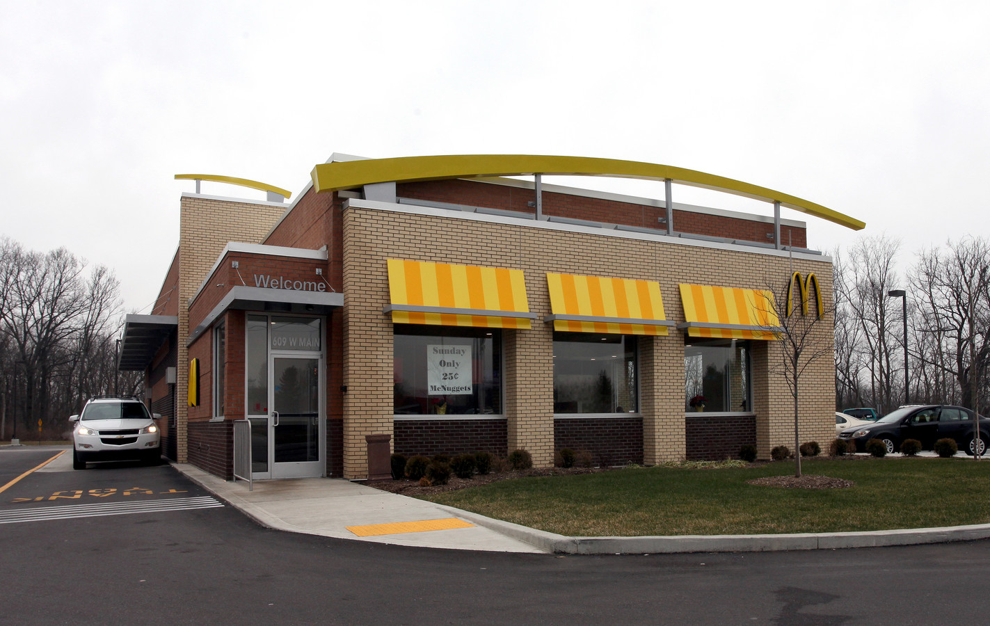
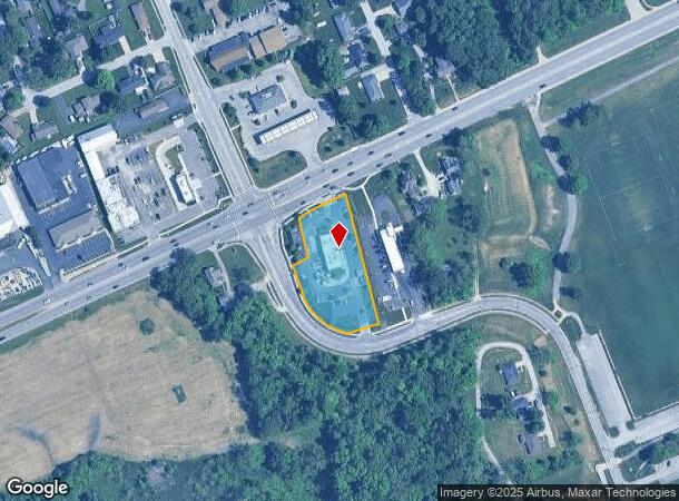
Property Record
609 W Main St, Plainfield, IN 46168
NEARBY LISTINGS FOR SALE OR LEASE
Property Detail
609 W Main St
Indianapolis-Carmel-Anderson, IN
Vestal Road Coml Secondary Pla
32-10-34-176-001.000-012
VESTAL ROAD COMMERCIAL PLAT PT LOT 1 1.259AC
Restaurantbuilding
Hendricks
X
Indiana
18109C0025E
1
2023
1.26 AC
2024
Hendricks County
210701
Indianapolis
3,602 SF
DEMOGRAPHICS near 609 W Main St
1 Mile
3 Mile
5 Mile
2024 Total Population
7,673
42,315
66,982
2029 Population
8,637
47,342
74,886
Pop Growth 2024-2029
+ 12.56%
+ 11.88%
+ 11.80%
Average Age
40
40
40
2024 Total Households
3,188
15,507
24,698
HH Growth 2024-2029
+ 12.77%
+ 12.03%
+ 11.91%
Median Household Inc
$65,416
$82,180
$87,350
Avg Household Size
2.40
2.50
2.60
2024 Avg HH Vehicles
2.00
2.00
2.00
Median Home Value
$224,856
$243,528
$247,439
Median Year Built
1992
1994
1996
Nearby Places
- Restaurants
- Banks
- Shops
- Fitness
- Groceries
PUBLIC TRANSPORTATION
AIRPORT
Indianapolis International
DRIVE
WALK
Distance
Indianapolis International
17 min
7.8 mi
Freight Ports
Port of Toledo
DRIVE
WALK
Distance
Port of Toledo
293 min
239.7 mi
Nearby Properties
Address
Land Use
TOTAL SIZE
Lot Size
Zoning
Address
Land Use
TOTAL SIZE
Lot Size
Zoning
923,980 SF
60.08 AC
Address
Land Use
TOTAL SIZE
Lot Size
Zoning
5,064 SF
25.50 AC
Address
Land Use
TOTAL SIZE
Lot Size
Zoning
750,820 SF
64.15 AC
Address
Land Use
TOTAL SIZE
Lot Size
Zoning
651,610 SF
63.52 AC
Address
Land Use
TOTAL SIZE
Lot Size
Zoning
635,585 SF
28.37 AC
Address
Land Use
TOTAL SIZE
Lot Size
Zoning
10,953 SF
18.52 AC
Address
Land Use
TOTAL SIZE
Lot Size
Zoning
518,536 SF
25.66 AC
Address
Land Use
TOTAL SIZE
Lot Size
Zoning
599,744 SF
34.65 AC
Address
Land Use
TOTAL SIZE
Lot Size
Zoning
3,443 SF
15.82 AC
Address
Land Use
TOTAL SIZE
Lot Size
Zoning
500,000 SF
28.58 AC
Address
Land Use
TOTAL SIZE
Lot Size
Zoning
476,720 SF
28.97 AC
Address
Land Use
TOTAL SIZE
Lot Size
Zoning
357,000 SF
27.34 AC
Address
Land Use
TOTAL SIZE
Lot Size
Zoning
Address
Land Use
TOTAL SIZE
Lot Size
Zoning
448,625 SF
23.82 AC
Address
Land Use
TOTAL SIZE
Lot Size
Zoning
454,260 SF
29.55 AC
Address
Land Use
TOTAL SIZE
Lot Size
Zoning
426,088 SF
23.11 AC
Address
Land Use
TOTAL SIZE
Lot Size
Zoning
4,933 SF
20.70 AC
Address
Land Use
TOTAL SIZE
Lot Size
Zoning
168,574 SF
8.30 AC
Address
Land Use
TOTAL SIZE
Lot Size
Zoning
2.31 AC
Address
Land Use
TOTAL SIZE
Lot Size
Zoning
363,072 SF
25.08 AC
Address
Land Use
TOTAL SIZE
Lot Size
Zoning
2,811 SF
14.97 AC
Address
Land Use
TOTAL SIZE
Lot Size
Zoning
371,601 SF
20.96 AC
Address
Land Use
TOTAL SIZE
Lot Size
Zoning
274,534 SF
13.47 AC
Address
Land Use
TOTAL SIZE
Lot Size
Zoning
235,986 SF
34.02 AC
Address
Land Use
TOTAL SIZE
Lot Size
Zoning
353,860 SF
15.40 AC
Address
Land Use
TOTAL SIZE
Lot Size
Zoning
62,800 SF
10.75 AC
Address
Land Use
TOTAL SIZE
Lot Size
Zoning
354,573 SF
70.34 AC
Address
Land Use
TOTAL SIZE
Lot Size
Zoning
16,224 SF
14.08 AC
Address
Land Use
TOTAL SIZE
Lot Size
Zoning
81,910 SF
10.62 AC
Address
Land Use
TOTAL SIZE
Lot Size
Zoning
220,302 SF
11.59 AC
The World's #1 Commercial Real Estate Marketplace
Connect with us
© 2025 CoStar Group
The information above has been obtained from sources believed reliable. While we do not doubt its accuracy we have not verified it and make no guarantee, warranty or representation about it. It is your responsibility to independently confirm its accuracy and completeness. Any projections, opinions, assumptions, or estimates used are for example only and do not represent the current or future performance of the property. The value of this transaction to you depends on tax and other factors which should be evaluated by your tax, financial, and legal advisors. You and your advisors should conduct a careful, independent investigation of the property to determine to your satisfaction the suitability of the property for your needs.