Property Record
610 Schumann Dr Nw, Stewartville, MN 55976
NEARBY LISTINGS FOR SALE OR LEASE
Property Detail
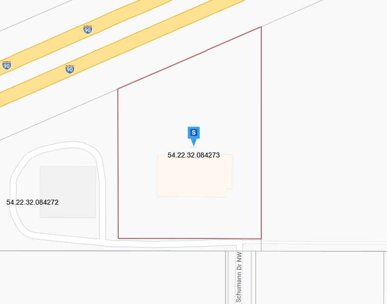
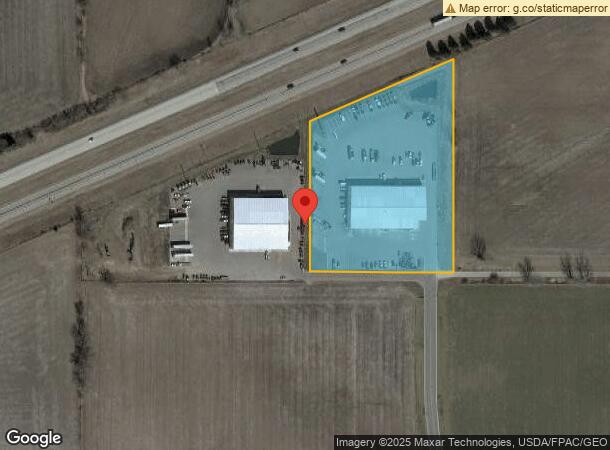
610 Schumann Dr Nw
Rochester, MN
Wb Subdivision
54.22.32.084273
SECT-22 TWP-105 RANGE-014 WB SUBDIVISION LOT-002 BLOCK-001
Autorepair
Olmsted
X
Minnesota
27109C0313E
2
2023
4.80 AC
2023
Rochester
0021001
Other Market Areas
24,988 SF
DEMOGRAPHICS near 610 Schumann Dr Nw
1 Mile
3 Mile
5 Mile
2024 Total Population
1,684
7,031
10,442
2029 Population
1,737
7,159
10,608
Pop Growth 2024-2029
+ 3.15%
+ 1.82%
+ 1.59%
Average Age
34
38
38
2024 Total Households
612
2,701
3,909
HH Growth 2024-2029
+ 3.27%
+ 1.70%
+ 1.46%
Median Household Inc
$91,919
$84,460
$95,782
Avg Household Size
2.70
2.50
2.60
2024 Avg HH Vehicles
2.00
2.00
2.00
Median Home Value
$236,470
$264,849
$309,584
Median Year Built
2010
1985
1992
Nearby Places
- Restaurants
- Banks
- Shops
- Fitness
- Groceries
PUBLIC TRANSPORTATION
AIRPORT
Rochester International
DRIVE
WALK
Distance
Rochester International
8 min
4.6 mi
Freight Ports
Port Milwaukee
DRIVE
WALK
Distance
Port Milwaukee
306 min
278.4 mi
Nearby Properties
Address
Land Use
TOTAL SIZE
Lot Size
Zoning
Address
Land Use
TOTAL SIZE
Lot Size
Zoning
968 SF
52.22 AC
Address
Land Use
TOTAL SIZE
Lot Size
Zoning
81,875 SF
155.34 AC
Address
Land Use
TOTAL SIZE
Lot Size
Zoning
600 SF
18.52 AC
Address
Land Use
TOTAL SIZE
Lot Size
Zoning
58,144 SF
2.97 AC
Address
Land Use
TOTAL SIZE
Lot Size
Zoning
117,752 SF
19.92 AC
Address
Land Use
TOTAL SIZE
Lot Size
Zoning
12,032 SF
6.03 AC
Address
Land Use
TOTAL SIZE
Lot Size
Zoning
60,228 SF
7.51 AC
Address
Land Use
TOTAL SIZE
Lot Size
Zoning
Address
Land Use
TOTAL SIZE
Lot Size
Zoning
33.82 AC
Address
Land Use
TOTAL SIZE
Lot Size
Zoning
65,924 SF
15.14 AC
Address
Land Use
TOTAL SIZE
Lot Size
Zoning
49,931 SF
1.42 AC
Address
Land Use
TOTAL SIZE
Lot Size
Zoning
7,896 SF
15.03 AC
Address
Land Use
TOTAL SIZE
Lot Size
Zoning
7,422 SF
13.57 AC
Address
Land Use
TOTAL SIZE
Lot Size
Zoning
35,011 SF
8.88 AC
Address
Land Use
TOTAL SIZE
Lot Size
Zoning
13.02 AC
Address
Land Use
TOTAL SIZE
Lot Size
Zoning
46,900 SF
3.14 AC
Address
Land Use
TOTAL SIZE
Lot Size
Zoning
29,609 SF
0.40 AC
Address
Land Use
TOTAL SIZE
Lot Size
Zoning
15,468 SF
2.34 AC
Address
Land Use
TOTAL SIZE
Lot Size
Zoning
231,582 SF
3.49 AC
Address
Land Use
TOTAL SIZE
Lot Size
Zoning
25,600 SF
8.62 AC
Address
Land Use
TOTAL SIZE
Lot Size
Zoning
11,100 SF
1.92 AC
Address
Land Use
TOTAL SIZE
Lot Size
Zoning
57,304 SF
8.43 AC
Address
Land Use
TOTAL SIZE
Lot Size
Zoning
21,600 SF
4.92 AC
Address
Land Use
TOTAL SIZE
Lot Size
Zoning
864 SF
0.94 AC
Address
Land Use
TOTAL SIZE
Lot Size
Zoning
46,346 SF
28.11 AC
Address
Land Use
TOTAL SIZE
Lot Size
Zoning
28,659 SF
1.47 AC
Address
Land Use
TOTAL SIZE
Lot Size
Zoning
22,324 SF
3.22 AC
Address
Land Use
TOTAL SIZE
Lot Size
Zoning
30,786 SF
3.89 AC
Address
Land Use
TOTAL SIZE
Lot Size
Zoning
2,349 SF
14.10 AC
The World's #1 Commercial Real Estate Marketplace
Connect with us
© 2025 CoStar Group
The information above has been obtained from sources believed reliable. While we do not doubt its accuracy we have not verified it and make no guarantee, warranty or representation about it. It is your responsibility to independently confirm its accuracy and completeness. Any projections, opinions, assumptions, or estimates used are for example only and do not represent the current or future performance of the property. The value of this transaction to you depends on tax and other factors which should be evaluated by your tax, financial, and legal advisors. You and your advisors should conduct a careful, independent investigation of the property to determine to your satisfaction the suitability of the property for your needs.