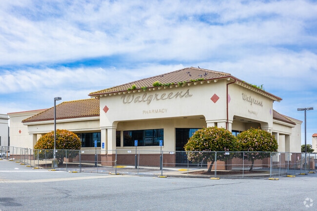
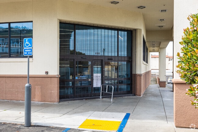
Property Record
6100 Mission St, Daly City, CA 94014

NEARBY LISTINGS FOR SALE OR LEASE
Property Detail
6100 Mission St
San Francisco-Redwood City-South San Francisco, CA
Mission St. Ext Hmstd Asoc
004-022-210
LOTS 402 THRU 415 & SELY 30 FT OF LOT 416 MISSION ST. EXT HMSTD ASOC RSM D/49
Storebuilding
San Mateo
X
California
06081C0029F
416
2024
1.38 AC
2025
Brisbane/Daly City
600701
San Francisco
13,905 SF
DEMOGRAPHICS near 6100 Mission St
1 Mile
3 Mile
5 Mile
2024 Total Population
53,784
258,569
656,841
2029 Population
49,196
238,408
608,748
Pop Growth 2024-2029
(8.53%)
(7.80%)
(7.32%)
Average Age
42
43
42
2024 Total Households
15,491
83,037
236,063
HH Growth 2024-2029
(8.84%)
(8.12%)
(7.69%)
Median Household Inc
$104,394
$114,594
$126,114
Avg Household Size
3.30
3.00
2.60
2024 Avg HH Vehicles
2.00
2.00
2.00
Median Home Value
$992,252
$1,069,839
$1,083,288
Median Year Built
1953
1953
1951
Nearby Places
Map Layers
Map Styles
 Street
 Aerial
- Restaurants
- Banks
- Shops
- Fitness
- Groceries
PUBLIC TRANSPORTATION
TRANSIT/SUBWAY
Broad And Plymouth (M Ocean View - San Francisco Municipal Railway (MUNI Metro), OCEAN VIEW - San Francisco Municipal Railway (MUNI Metro))
DRIVE
WALK
Distance
Broad And Plymouth (M Ocean View - San Francisco Municipal Railway (MUNI Metro), OCEAN VIEW - San Francisco Municipal Railway (MUNI Metro))
1 min
9 min
0.5 mi
Broad And Orizaba (M Ocean View - San Francisco Municipal Railway (MUNI Metro), OCEAN VIEW - San Francisco Municipal Railway (MUNI Metro))
DRIVE
WALK
Distance
Broad And Orizaba (M Ocean View - San Francisco Municipal Railway (MUNI Metro), OCEAN VIEW - San Francisco Municipal Railway (MUNI Metro))
2 min
10 min
0.5 mi
Orizaba Ave & Broad St (OCEAN VIEW - San Francisco Municipal Transportation Agency)
DRIVE
WALK
Distance
Orizaba Ave & Broad St (OCEAN VIEW - San Francisco Municipal Transportation Agency)
2 min
10 min
0.6 mi
Broad St & Capitol Ave (OCEAN VIEW - San Francisco Municipal Transportation Agency)
DRIVE
WALK
Distance
Broad St & Capitol Ave (OCEAN VIEW - San Francisco Municipal Transportation Agency)
2 min
12 min
0.6 mi
Broad And Capitol (M Ocean View - San Francisco Municipal Railway (MUNI Metro))
DRIVE
WALK
Distance
Broad And Capitol (M Ocean View - San Francisco Municipal Railway (MUNI Metro))
2 min
12 min
0.6 mi
COMMUTER RAIL
Bayshore Caltrain Station (Local - Caltrain (Caltrain), Local Weekday - Caltrain (Caltrain), Local Weekend - Caltrain (Caltrain))
DRIVE
WALK
Distance
Bayshore Caltrain Station (Local - Caltrain (Caltrain), Local Weekday - Caltrain (Caltrain), Local Weekend - Caltrain (Caltrain))
9 min
5.7 mi
South San Francisco (Caltrain - Caltrain (Caltrain), Express - Caltrain (Caltrain), Limited - Caltrain (Caltrain), Local Weekday - Caltrain (Caltrain), Local Weekend - Caltrain (Caltrain))
DRIVE
WALK
Distance
South San Francisco (Caltrain - Caltrain (Caltrain), Express - Caltrain (Caltrain), Limited - Caltrain (Caltrain), Local Weekday - Caltrain (Caltrain), Local Weekend - Caltrain (Caltrain))
13 min
6.8 mi
AIRPORT
San Francisco International
DRIVE
WALK
Distance
San Francisco International
18 min
11.1 mi
Metro Oakland International
DRIVE
WALK
Distance
Metro Oakland International
38 min
26.3 mi
Freight Ports
Port of San Francisco
DRIVE
WALK
Distance
Port of San Francisco
14 min
8.9 mi
SALE & LEASE HISTORY
LISTING DATE
SALE/LEASE

Jan 23, 2025
For Sale
Jan 13, 2025
For Lease
Nearby Properties
Address
Land Use
TOTAL SIZE
Lot Size
Zoning
Address
Land Use
TOTAL SIZE
Lot Size
Zoning
411,904 SF
21.74 AC
C2
Address
Land Use
TOTAL SIZE
Lot Size
Zoning
53.85 AC
Address
Land Use
TOTAL SIZE
Lot Size
Zoning
346,710 SF
7.45 AC
RH2
Address
Land Use
TOTAL SIZE
Lot Size
Zoning
312,191 SF
2.74 AC
Address
Land Use
TOTAL SIZE
Lot Size
Zoning
42.95 AC
Address
Land Use
TOTAL SIZE
Lot Size
Zoning
447,674 SF
21.51 AC
Address
Land Use
TOTAL SIZE
Lot Size
Zoning
183,284 SF
6.85 AC
PD0000
Address
Land Use
TOTAL SIZE
Lot Size
Zoning
2.03 AC
C2
Address
Land Use
TOTAL SIZE
Lot Size
Zoning
88,900 SF
5.37 AC
NCS
Address
Land Use
TOTAL SIZE
Lot Size
Zoning
11.31 AC
RM2
Address
Land Use
TOTAL SIZE
Lot Size
Zoning
160,983 SF
1.84 AC
NC2
Address
Land Use
TOTAL SIZE
Lot Size
Zoning
279,560 SF
13.24 AC
M10000
Address
Land Use
TOTAL SIZE
Lot Size
Zoning
10.62 AC
Address
Land Use
TOTAL SIZE
Lot Size
Zoning
Address
Land Use
TOTAL SIZE
Lot Size
Zoning
95,469 SF
3.68 AC
RH-1
Address
Land Use
TOTAL SIZE
Lot Size
Zoning
2,011 SF
2.49 AC
Address
Land Use
TOTAL SIZE
Lot Size
Zoning
73,491 SF
4.48 AC
C2
Address
Land Use
TOTAL SIZE
Lot Size
Zoning
12,555 SF
0.74 AC
NCS
Address
Land Use
TOTAL SIZE
Lot Size
Zoning
176,000 SF
1.64 AC
C2
Address
Land Use
TOTAL SIZE
Lot Size
Zoning
3.77 AC
Address
Land Use
TOTAL SIZE
Lot Size
Zoning
54,131 SF
1.75 AC
C2
Address
Land Use
TOTAL SIZE
Lot Size
Zoning
181,172 SF
2.11 AC
Address
Land Use
TOTAL SIZE
Lot Size
Zoning
141,956 SF
1.74 AC
Address
Land Use
TOTAL SIZE
Lot Size
Zoning
73.91 AC
Address
Land Use
TOTAL SIZE
Lot Size
Zoning
206.09 AC
Address
Land Use
TOTAL SIZE
Lot Size
Zoning
67,432 SF
4.55 AC
CL00C1
Address
Land Use
TOTAL SIZE
Lot Size
Zoning
113,136 SF
9.09 AC
G10000
Address
Land Use
TOTAL SIZE
Lot Size
Zoning
87,525 SF
1.65 AC
RM1
Address
Land Use
TOTAL SIZE
Lot Size
Zoning
113,782 SF
2.90 AC
Address
Land Use
TOTAL SIZE
Lot Size
Zoning
6.80 AC
RM1
The World's #1 Commercial Real Estate Marketplace
Connect with us
© 2025 CoStar Group
The information above has been obtained from sources believed reliable. While we do not doubt its accuracy we have not verified it and make no guarantee, warranty or representation about it. It is your responsibility to independently confirm its accuracy and completeness. Any projections, opinions, assumptions, or estimates used are for example only and do not represent the current or future performance of the property. The value of this transaction to you depends on tax and other factors which should be evaluated by your tax, financial, and legal advisors. You and your advisors should conduct a careful, independent investigation of the property to determine to your satisfaction the suitability of the property for your needs.