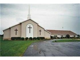
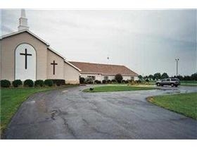
Property Record
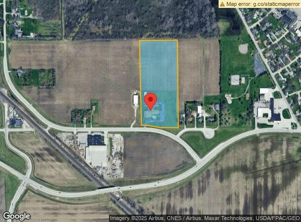
6100 N Drouillard Rd, Northwood, OH 43619
NEARBY LISTINGS FOR SALE OR LEASE
-
-
View all Northwood listings for sale on LoopNet.com
Property Detail
6100 N Drouillard Rd
M50-812-330104061000
E425 W2024 S1061 SNW LESS .40 A PT FOR RD
Religious
Wood
X
Ohio
39173C0051D
9.96 AC
2023
Perrysburg/Northwood
2023
Toledo
020100
Toledo, OH
10,415 SF
DEMOGRAPHICS near 6100 N Drouillard Rd
1 Mile
3 Mile
5 Mile
2024 Total Population
2,298
38,712
90,231
2029 Population
2,329
38,506
90,672
Pop Growth 2024-2029
+ 1.35%
(0.53%)
+ 0.49%
Average Age
42
40
39
2024 Total Households
929
16,138
37,677
HH Growth 2024-2029
+ 1.29%
(0.59%)
+ 0.38%
Median Household Inc
$66,260
$49,360
$43,183
Avg Household Size
2.40
2.30
2.30
2024 Avg HH Vehicles
2.00
2.00
2.00
Median Home Value
$159,041
$133,825
$121,340
Median Year Built
1971
1960
1958
Nearby Places
- Restaurants
- Banks
- Shops
- Fitness
- Groceries
PUBLIC TRANSPORTATION
COMMUTER RAIL
Toledo (Capitol Limited - Amtrak, Lake Shore Limited - Amtrak)
DRIVE
WALK
Distance
Toledo (Capitol Limited - Amtrak, Lake Shore Limited - Amtrak)
10 min
4.7 mi
AIRPORT
Eugene F Kranz Toledo Express
DRIVE
WALK
Distance
Eugene F Kranz Toledo Express
41 min
22.8 mi
Freight Ports
Port of Toledo
DRIVE
WALK
Distance
Port of Toledo
17 min
7.1 mi
Nearby Properties
Address
Land Use
TOTAL SIZE
Lot Size
Zoning
Address
Land Use
TOTAL SIZE
Lot Size
Zoning
605,609 SF
9.66 AC
40-C4
Address
Land Use
TOTAL SIZE
Lot Size
Zoning
313,004 SF
44.54 AC
40-C2
Address
Land Use
TOTAL SIZE
Lot Size
Zoning
219,265 SF
32.11 AC
Address
Land Use
TOTAL SIZE
Lot Size
Zoning
136,090 SF
4 AC
Address
Land Use
TOTAL SIZE
Lot Size
Zoning
73,802 SF
22.50 AC
40-MX
Address
Land Use
TOTAL SIZE
Lot Size
Zoning
127,658 SF
9.01 AC
40-C4
Address
Land Use
TOTAL SIZE
Lot Size
Zoning
170,760 SF
51.98 AC
Address
Land Use
TOTAL SIZE
Lot Size
Zoning
225,918 SF
17.15 AC
Address
Land Use
TOTAL SIZE
Lot Size
Zoning
349,799 SF
51.86 AC
Address
Land Use
TOTAL SIZE
Lot Size
Zoning
228,251 SF
43.08 AC
10-RD6
Address
Land Use
TOTAL SIZE
Lot Size
Zoning
100,531 SF
3.07 AC
Address
Land Use
TOTAL SIZE
Lot Size
Zoning
214,312 SF
35.35 AC
40-MX
Address
Land Use
TOTAL SIZE
Lot Size
Zoning
152,163 SF
2.49 AC
Address
Land Use
TOTAL SIZE
Lot Size
Zoning
34 AC
40-C5
Address
Land Use
TOTAL SIZE
Lot Size
Zoning
65,683 SF
5.02 AC
10-MX
Address
Land Use
TOTAL SIZE
Lot Size
Zoning
351,114 SF
26.32 AC
10-MX
Address
Land Use
TOTAL SIZE
Lot Size
Zoning
230,074 SF
142.89 AC
40-M2
Address
Land Use
TOTAL SIZE
Lot Size
Zoning
102,535 SF
20 AC
40-R2
Address
Land Use
TOTAL SIZE
Lot Size
Zoning
58,838 SF
1 AC
10-RD6
Address
Land Use
TOTAL SIZE
Lot Size
Zoning
181,347 SF
14.12 AC
40-R4
Address
Land Use
TOTAL SIZE
Lot Size
Zoning
132,284 SF
22.10 AC
Address
Land Use
TOTAL SIZE
Lot Size
Zoning
331,416 SF
30.56 AC
Address
Land Use
TOTAL SIZE
Lot Size
Zoning
61,289 SF
2 AC
10-RD6
Address
Land Use
TOTAL SIZE
Lot Size
Zoning
229,500 SF
9.97 AC
Address
Land Use
TOTAL SIZE
Lot Size
Zoning
58,281 SF
2.60 AC
NotZoned
Address
Land Use
TOTAL SIZE
Lot Size
Zoning
180,900 SF
5 AC
Address
Land Use
TOTAL SIZE
Lot Size
Zoning
117,094 SF
28.04 AC
40-R2
Address
Land Use
TOTAL SIZE
Lot Size
Zoning
106,525 SF
18.90 AC
Address
Land Use
TOTAL SIZE
Lot Size
Zoning
124,380 SF
9.39 AC
Address
Land Use
TOTAL SIZE
Lot Size
Zoning
178,841 SF
19 AC
10-RM36
The World's #1 Commercial Real Estate Marketplace
Connect with us
© 2025 CoStar Group
The information above has been obtained from sources believed reliable. While we do not doubt its accuracy we have not verified it and make no guarantee, warranty or representation about it. It is your responsibility to independently confirm its accuracy and completeness. Any projections, opinions, assumptions, or estimates used are for example only and do not represent the current or future performance of the property. The value of this transaction to you depends on tax and other factors which should be evaluated by your tax, financial, and legal advisors. You and your advisors should conduct a careful, independent investigation of the property to determine to your satisfaction the suitability of the property for your needs.