Property Record
6108 Blue Ridge Blvd, Raytown, MO 64133
NEARBY LISTINGS FOR SALE OR LEASE
Property Detail
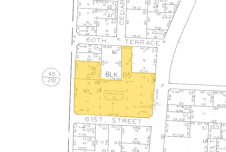
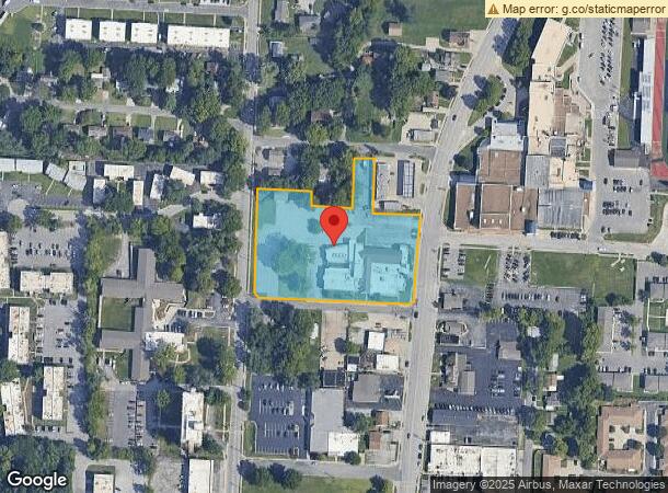
6108 Blue Ridge Blvd
Kansas City, MO-KS
Askansas Heights
45-120-05-16-00-0-00-000
ASKANSAS HEIGHTS---ALL OF LOTS 20-30 & 33-38 & TH S 59.61 OF LOTS 29 & 30 (KNOWN AS TRACT 1 ON CERT
Religious
Jackson
X
Missouri
29095C0289G
21
0
2.97 AC
2024
East Jackson County
0125012037
Kansas City
49,839 SF
DEMOGRAPHICS near 6108 Blue Ridge Blvd
1 Mile
3 Mile
5 Mile
2024 Total Population
9,067
53,602
133,495
2029 Population
9,035
53,226
132,884
Pop Growth 2024-2029
(0.35%)
(0.70%)
(0.46%)
Average Age
42
41
41
2024 Total Households
3,847
22,321
55,450
HH Growth 2024-2029
(0.47%)
(0.84%)
(0.58%)
Median Household Inc
$59,903
$59,363
$56,593
Avg Household Size
2.20
2.30
2.30
2024 Avg HH Vehicles
2.00
2.00
2.00
Median Home Value
$144,938
$150,734
$153,757
Median Year Built
1961
1965
1965
Nearby Places
- Restaurants
- Banks
- Shops
- Fitness
- Groceries
PUBLIC TRANSPORTATION
COMMUTER RAIL
Independence Amtrak Station (Lincoln Service Missouri River Runner - Amtrak, Missouri River Runner - Amtrak)
DRIVE
WALK
Distance
Independence Amtrak Station (Lincoln Service Missouri River Runner - Amtrak, Missouri River Runner - Amtrak)
14 min
6.4 mi
Lee's Summit Amtrak (Lincoln Service Missouri River Runner - Amtrak, Missouri River Runner - Amtrak)
DRIVE
WALK
Distance
Lee's Summit Amtrak (Lincoln Service Missouri River Runner - Amtrak, Missouri River Runner - Amtrak)
17 min
9.9 mi
AIRPORT
Kansas City International
DRIVE
WALK
Distance
Kansas City International
44 min
30.7 mi
Freight Ports
Tulsa Port Of Catoosa
DRIVE
WALK
Distance
Tulsa Port Of Catoosa
268 min
237.3 mi
Nearby Properties
Address
Land Use
TOTAL SIZE
Lot Size
Zoning
Address
Land Use
TOTAL SIZE
Lot Size
Zoning
18.82 AC
Address
Land Use
TOTAL SIZE
Lot Size
Zoning
112,500 SF
26.32 AC
Address
Land Use
TOTAL SIZE
Lot Size
Zoning
62,211 SF
39.88 AC
Address
Land Use
TOTAL SIZE
Lot Size
Zoning
145,237 SF
26.37 AC
Address
Land Use
TOTAL SIZE
Lot Size
Zoning
137,428 SF
27.76 AC
Address
Land Use
TOTAL SIZE
Lot Size
Zoning
210,008 SF
16.89 AC
Address
Land Use
TOTAL SIZE
Lot Size
Zoning
168,184 SF
18.63 AC
Address
Land Use
TOTAL SIZE
Lot Size
Zoning
389,178 SF
33.30 AC
Address
Land Use
TOTAL SIZE
Lot Size
Zoning
148,196 SF
1.79 AC
Address
Land Use
TOTAL SIZE
Lot Size
Zoning
34,832 SF
8.29 AC
Address
Land Use
TOTAL SIZE
Lot Size
Zoning
42,188 SF
7.82 AC
Address
Land Use
TOTAL SIZE
Lot Size
Zoning
173,321 SF
40 AC
Address
Land Use
TOTAL SIZE
Lot Size
Zoning
Address
Land Use
TOTAL SIZE
Lot Size
Zoning
82,607 SF
9.90 AC
Address
Land Use
TOTAL SIZE
Lot Size
Zoning
103,866 SF
13.29 AC
Address
Land Use
TOTAL SIZE
Lot Size
Zoning
127,732 SF
152 AC
Address
Land Use
TOTAL SIZE
Lot Size
Zoning
175,502 SF
0.27 AC
Address
Land Use
TOTAL SIZE
Lot Size
Zoning
145,569 SF
16.90 AC
Address
Land Use
TOTAL SIZE
Lot Size
Zoning
65,969 SF
10.35 AC
Address
Land Use
TOTAL SIZE
Lot Size
Zoning
71,368 SF
5.64 AC
Address
Land Use
TOTAL SIZE
Lot Size
Zoning
333,682 SF
11.54 AC
Address
Land Use
TOTAL SIZE
Lot Size
Zoning
9.57 AC
Address
Land Use
TOTAL SIZE
Lot Size
Zoning
Address
Land Use
TOTAL SIZE
Lot Size
Zoning
82,432 SF
5.24 AC
Address
Land Use
TOTAL SIZE
Lot Size
Zoning
20,318 SF
9.45 AC
Address
Land Use
TOTAL SIZE
Lot Size
Zoning
47,150 SF
8.20 AC
Address
Land Use
TOTAL SIZE
Lot Size
Zoning
35,646 SF
3.25 AC
Address
Land Use
TOTAL SIZE
Lot Size
Zoning
71,078 SF
9.50 AC
Address
Land Use
TOTAL SIZE
Lot Size
Zoning
21,600 SF
4.36 AC
Address
Land Use
TOTAL SIZE
Lot Size
Zoning
22,913 SF
151.50 AC
The World's #1 Commercial Real Estate Marketplace
Connect with us
© 2025 CoStar Group
The information above has been obtained from sources believed reliable. While we do not doubt its accuracy we have not verified it and make no guarantee, warranty or representation about it. It is your responsibility to independently confirm its accuracy and completeness. Any projections, opinions, assumptions, or estimates used are for example only and do not represent the current or future performance of the property. The value of this transaction to you depends on tax and other factors which should be evaluated by your tax, financial, and legal advisors. You and your advisors should conduct a careful, independent investigation of the property to determine to your satisfaction the suitability of the property for your needs.