Property Record
611 Main St, Brownsville, WI 53006


NEARBY LISTINGS FOR SALE OR LEASE
-
-
View all Brownsville listings for sale on LoopNet.com
Property Detail
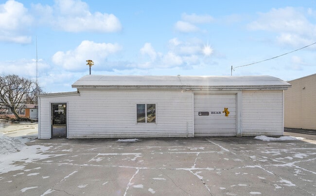
611 Main St
Beaver Dam, WI
All In Assessors Plat Number 1
106-1317-0821-023
LOT 61 & E 17 FT LOT 60 BROWNSVILLE ASSESSOR'S PLAT #1
Commercialnec
Dodge
X
Wisconsin
55039C0550G
61,60
2024
0.24 AC
2024
Dodge East
960100
Milwaukee/Madison
DEMOGRAPHICS near 611 Main St
1 Mile
3 Mile
5 Mile
2024 Total Population
763
2,578
5,553
2029 Population
756
2,537
5,433
Pop Growth 2024-2029
(0.92%)
(1.59%)
(2.16%)
Average Age
41
41
42
2024 Total Households
311
1,038
2,233
HH Growth 2024-2029
(1.29%)
(1.73%)
(2.28%)
Median Household Inc
$60,395
$66,260
$70,624
Avg Household Size
2.50
2.50
2.50
2024 Avg HH Vehicles
2.00
2.00
2.00
Median Home Value
$241,935
$218,669
$210,551
Median Year Built
1973
1979
1977
Nearby Places
Map Layers
Map Styles
 Street
 Aerial
- Restaurants
- Banks
- Shops
- Fitness
- Groceries
SALE & LEASE HISTORY
LISTING DATE
SALE/LEASE

Jan 07, 2025
For Sale
Nearby Properties
Address
Land Use
TOTAL SIZE
Lot Size
Zoning
Address
Land Use
TOTAL SIZE
Lot Size
Zoning
61.08 AC
Address
Land Use
TOTAL SIZE
Lot Size
Zoning
Address
Land Use
TOTAL SIZE
Lot Size
Zoning
30.01 AC
Address
Land Use
TOTAL SIZE
Lot Size
Zoning
45.92 AC
Address
Land Use
TOTAL SIZE
Lot Size
Zoning
20.05 AC
Address
Land Use
TOTAL SIZE
Lot Size
Zoning
28.42 AC
Address
Land Use
TOTAL SIZE
Lot Size
Zoning
Address
Land Use
TOTAL SIZE
Lot Size
Zoning
14.01 AC
Address
Land Use
TOTAL SIZE
Lot Size
Zoning
Address
Land Use
TOTAL SIZE
Lot Size
Zoning
14.84 AC
Address
Land Use
TOTAL SIZE
Lot Size
Zoning
1.59 AC
Address
Land Use
TOTAL SIZE
Lot Size
Zoning
18.42 AC
Address
Land Use
TOTAL SIZE
Lot Size
Zoning
Address
Land Use
TOTAL SIZE
Lot Size
Zoning
39.39 AC
Address
Land Use
TOTAL SIZE
Lot Size
Zoning
2.48 AC
Address
Land Use
TOTAL SIZE
Lot Size
Zoning
1.72 AC
Address
Land Use
TOTAL SIZE
Lot Size
Zoning
Address
Land Use
TOTAL SIZE
Lot Size
Zoning
40.05 AC
Address
Land Use
TOTAL SIZE
Lot Size
Zoning
Address
Land Use
TOTAL SIZE
Lot Size
Zoning
0.69 AC
Address
Land Use
TOTAL SIZE
Lot Size
Zoning
Address
Land Use
TOTAL SIZE
Lot Size
Zoning
0.72 AC
Address
Land Use
TOTAL SIZE
Lot Size
Zoning
18.81 AC
Address
Land Use
TOTAL SIZE
Lot Size
Zoning
0.40 AC
Address
Land Use
TOTAL SIZE
Lot Size
Zoning
0.80 AC
Address
Land Use
TOTAL SIZE
Lot Size
Zoning
47.03 AC
Address
Land Use
TOTAL SIZE
Lot Size
Zoning
5.62 AC
Address
Land Use
TOTAL SIZE
Lot Size
Zoning
5.27 AC
Address
Land Use
TOTAL SIZE
Lot Size
Zoning
14.06 AC
Address
Land Use
TOTAL SIZE
Lot Size
Zoning
1.30 AC
The World's #1 Commercial Real Estate Marketplace
Connect with us
© 2025 CoStar Group
The information above has been obtained from sources believed reliable. While we do not doubt its accuracy we have not verified it and make no guarantee, warranty or representation about it. It is your responsibility to independently confirm its accuracy and completeness. Any projections, opinions, assumptions, or estimates used are for example only and do not represent the current or future performance of the property. The value of this transaction to you depends on tax and other factors which should be evaluated by your tax, financial, and legal advisors. You and your advisors should conduct a careful, independent investigation of the property to determine to your satisfaction the suitability of the property for your needs.