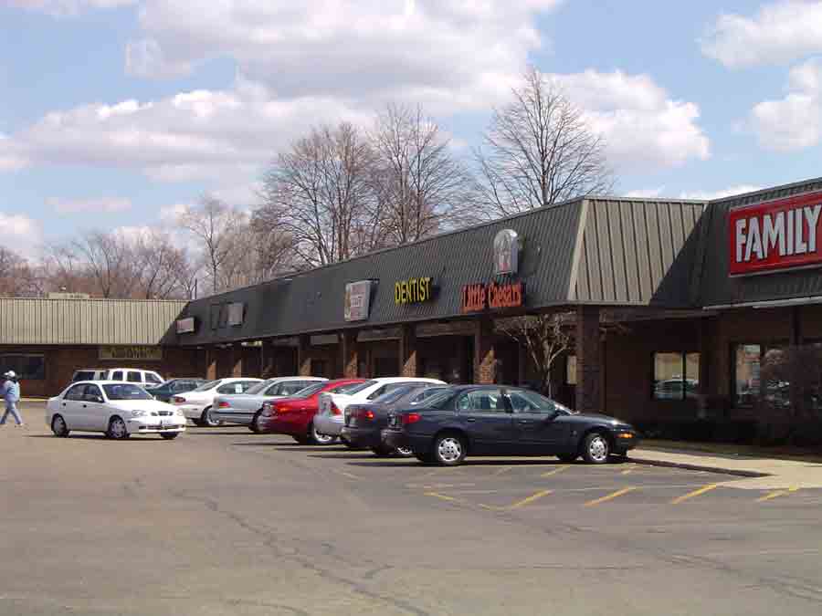
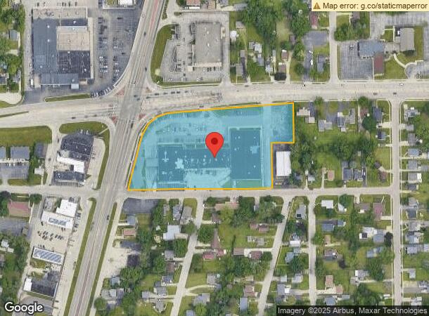
Property Record
613 Harlem Rd, Machesney Park, IL 61115

Current Lease Availabilities
NEARBY LISTINGS FOR SALE OR LEASE
Property Detail
613 Harlem Rd
Rockford, IL
Evans Park Sub
08-31-126-015
3.32A TR COMM AT THE SE COR LT 8 TH N184 FT TO POB TH N 161.12 FT SWLY 510.55 FT SWLY 161.44 FT
Commercialnec
Winnebago
X
Illinois
17201C0258E
8
2022
4.40 AC
2022
I-39 Corr/Winnebago Cnty
000103
Chicago
53,254 SF
DEMOGRAPHICS near 613 Harlem Rd
1 Mile
3 Mile
5 Mile
2024 Total Population
10,141
49,067
119,305
2029 Population
10,015
48,222
117,621
Pop Growth 2024-2029
(1.24%)
(1.72%)
(1.41%)
Average Age
40
42
41
2024 Total Households
4,155
20,765
49,915
HH Growth 2024-2029
(1.28%)
(1.77%)
(1.47%)
Median Household Inc
$55,542
$56,091
$57,803
Avg Household Size
2.40
2.30
2.30
2024 Avg HH Vehicles
2.00
2.00
2.00
Median Home Value
$92,545
$136,708
$143,791
Median Year Built
1966
1972
1969
Nearby Places
- Restaurants
- Banks
- Shops
- Fitness
- Groceries
PUBLIC TRANSPORTATION
AIRPORT
Chicago/Rockford International
DRIVE
WALK
Distance
Chicago/Rockford International
26 min
14.4 mi
Freight Ports
Port Milwaukee
DRIVE
WALK
Distance
Port Milwaukee
106 min
87.8 mi
Nearby Properties
Address
Land Use
TOTAL SIZE
Lot Size
Zoning
Address
Land Use
TOTAL SIZE
Lot Size
Zoning
189,000 SF
56.75 AC
IL - INDUS
Address
Land Use
TOTAL SIZE
Lot Size
Zoning
105,664 SF
13.34 AC
Address
Land Use
TOTAL SIZE
Lot Size
Zoning
126,838 SF
7.96 AC
Address
Land Use
TOTAL SIZE
Lot Size
Zoning
212,200 SF
21 AC
C3
Address
Land Use
TOTAL SIZE
Lot Size
Zoning
256,236 SF
29.33 AC
R3
Address
Land Use
TOTAL SIZE
Lot Size
Zoning
192,604 SF
17.05 AC
Address
Land Use
TOTAL SIZE
Lot Size
Zoning
51,580 SF
6.13 AC
Address
Land Use
TOTAL SIZE
Lot Size
Zoning
150,739 SF
12.14 AC
Address
Land Use
TOTAL SIZE
Lot Size
Zoning
112,035 SF
8.79 AC
Address
Land Use
TOTAL SIZE
Lot Size
Zoning
114,176 SF
4.94 AC
R4
Address
Land Use
TOTAL SIZE
Lot Size
Zoning
676,780 SF
32.88 AC
IG
Address
Land Use
TOTAL SIZE
Lot Size
Zoning
144,107 SF
17.90 AC
R3
Address
Land Use
TOTAL SIZE
Lot Size
Zoning
175,502 SF
18.15 AC
Address
Land Use
TOTAL SIZE
Lot Size
Zoning
125,024 SF
9.91 AC
Address
Land Use
TOTAL SIZE
Lot Size
Zoning
Address
Land Use
TOTAL SIZE
Lot Size
Zoning
124,757 SF
13.41 AC
Address
Land Use
TOTAL SIZE
Lot Size
Zoning
151,517 SF
7.52 AC
R3
Address
Land Use
TOTAL SIZE
Lot Size
Zoning
Address
Land Use
TOTAL SIZE
Lot Size
Zoning
13.45 AC
Address
Land Use
TOTAL SIZE
Lot Size
Zoning
160,937 SF
10 AC
CR
Address
Land Use
TOTAL SIZE
Lot Size
Zoning
340,180 SF
25.40 AC
IL
Address
Land Use
TOTAL SIZE
Lot Size
Zoning
78,968 SF
13.64 AC
R2
Address
Land Use
TOTAL SIZE
Lot Size
Zoning
16,500 SF
10.62 AC
Address
Land Use
TOTAL SIZE
Lot Size
Zoning
58,526 SF
134.42 AC
RE
Address
Land Use
TOTAL SIZE
Lot Size
Zoning
243,057 SF
C2
Address
Land Use
TOTAL SIZE
Lot Size
Zoning
103,326 SF
10.52 AC
Address
Land Use
TOTAL SIZE
Lot Size
Zoning
79,047 SF
7.92 AC
CR
Address
Land Use
TOTAL SIZE
Lot Size
Zoning
60,479 SF
117 AC
R1
Address
Land Use
TOTAL SIZE
Lot Size
Zoning
119,108 SF
3.06 AC
R3
Address
Land Use
TOTAL SIZE
Lot Size
Zoning
6.89 AC
RE
The World's #1 Commercial Real Estate Marketplace
Connect with us
© 2025 CoStar Group
The information above has been obtained from sources believed reliable. While we do not doubt its accuracy we have not verified it and make no guarantee, warranty or representation about it. It is your responsibility to independently confirm its accuracy and completeness. Any projections, opinions, assumptions, or estimates used are for example only and do not represent the current or future performance of the property. The value of this transaction to you depends on tax and other factors which should be evaluated by your tax, financial, and legal advisors. You and your advisors should conduct a careful, independent investigation of the property to determine to your satisfaction the suitability of the property for your needs.