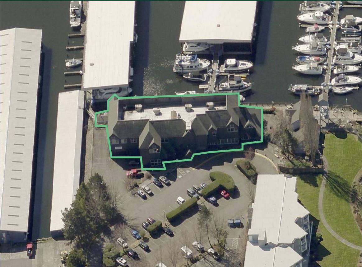
Property Record
6161 Ne 175Th St, Kenmore, WA 98028
NEARBY LISTINGS FOR SALE OR LEASE
Property Detail
6161 Ne 175Th St
Seattle-Tacoma-Bellevue, WA
Second Class Shorelands Adjoining
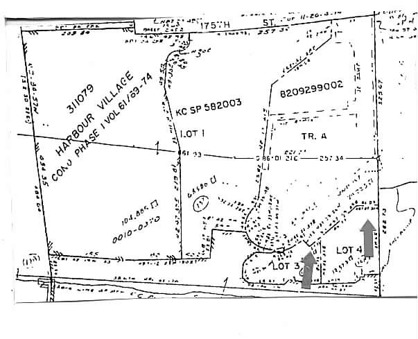
112604-9167
LOT 3 TGW UND INT IN TR A KCSP 582003 REC NO 8209299002 SD SP DAF - POR OF GL 3 & 2ND CL TD LDS ADJ BEG N 1/4 COR SEC 11 TH S 2-52-28 W ALG E LN GL 3 1786.59 FT TO S LN NE 175TH ST & TPOB TH CONT S 2-52-28 W ALG E LN SD GL 3 & SD LN EXTND 544.72 FT T
Officebuilding
King
X
Washington
53033C0044G
3
2025
0.19 AC
2024
Bothell/Kenmore
021600
Seattle/Puget Sound
16,903 SF
DEMOGRAPHICS near 6161 Ne 175Th St
1 Mile
3 Mile
5 Mile
2024 Total Population
10,751
114,520
365,801
2029 Population
10,829
116,277
374,144
Pop Growth 2024-2029
+ 0.73%
+ 1.53%
+ 2.28%
Average Age
42
41
40
2024 Total Households
4,480
46,012
148,899
HH Growth 2024-2029
+ 0.63%
+ 1.51%
+ 2.29%
Median Household Inc
$115,902
$113,681
$106,858
Avg Household Size
2.40
2.40
2.40
2024 Avg HH Vehicles
2.00
2.00
2.00
Median Home Value
$796,956
$774,318
$763,095
Median Year Built
1980
1979
1980
Nearby Places
- Restaurants
- Banks
- Shops
- Fitness
- Groceries
PUBLIC TRANSPORTATION
COMMUTER RAIL
Edmonds Station (Sounder South Line - Central Puget Sound Regional Transit Authority Rail (Link Light Rail/Sounder))
DRIVE
WALK
Distance
Edmonds Station (Sounder South Line - Central Puget Sound Regional Transit Authority Rail (Link Light Rail/Sounder))
18 min
8.4 mi
AIRPORT
Seattle Paine Field International
DRIVE
WALK
Distance
Seattle Paine Field International
25 min
12.7 mi
Seattle-Tacoma International
DRIVE
WALK
Distance
Seattle-Tacoma International
43 min
27.3 mi
Freight Ports
Port of Seattle
DRIVE
WALK
Distance
Port of Seattle
30 min
17.8 mi
SALE & LEASE HISTORY
LISTING DATE
SALE/LEASE

Jun 07, 2022
For Lease
Nearby Properties
Address
Land Use
TOTAL SIZE
Lot Size
Zoning
Address
Land Use
TOTAL SIZE
Lot Size
Zoning
11.29 AC
R-AC, OP,
Address
Land Use
TOTAL SIZE
Lot Size
Zoning
444,231 SF
31.50 AC
SDD/R
Address
Land Use
TOTAL SIZE
Lot Size
Zoning
2.60 AC
DN
Address
Land Use
TOTAL SIZE
Lot Size
Zoning
194,388 SF
1.65 AC
DC
Address
Land Use
TOTAL SIZE
Lot Size
Zoning
170,520 SF
1.92 AC
DN
Address
Land Use
TOTAL SIZE
Lot Size
Zoning
8,000 SF
75.38 AC
C
Address
Land Use
TOTAL SIZE
Lot Size
Zoning
75,661 SF
30.54 AC
R 8400
Address
Land Use
TOTAL SIZE
Lot Size
Zoning
170,408 SF
1.85 AC
NC3-75 (M)
Address
Land Use
TOTAL SIZE
Lot Size
Zoning
131,236 SF
19.14 AC
R6
Address
Land Use
TOTAL SIZE
Lot Size
Zoning
184,576 SF
9.56 AC
RMA 1.8
Address
Land Use
TOTAL SIZE
Lot Size
Zoning
204,428 SF
34.65 AC
R 9600
Address
Land Use
TOTAL SIZE
Lot Size
Zoning
119,470 SF
1.56 AC
DN
Address
Land Use
TOTAL SIZE
Lot Size
Zoning
223,338 SF
2.05 AC
F/T
Address
Land Use
TOTAL SIZE
Lot Size
Zoning
177,990 SF
50.72 AC
PUBLIC/SEM
Address
Land Use
TOTAL SIZE
Lot Size
Zoning
194,954 SF
49.73 AC
PUBLIC/SEM
Address
Land Use
TOTAL SIZE
Lot Size
Zoning
120,420 SF
0.94 AC
DN
Address
Land Use
TOTAL SIZE
Lot Size
Zoning
220,968 SF
16.46 AC
TC
Address
Land Use
TOTAL SIZE
Lot Size
Zoning
3,284 SF
72.10 AC
R6
Address
Land Use
TOTAL SIZE
Lot Size
Zoning
217,527 SF
1.26 AC
BC/D
Address
Land Use
TOTAL SIZE
Lot Size
Zoning
236,309 SF
43.88 AC
R6
Address
Land Use
TOTAL SIZE
Lot Size
Zoning
95,892 SF
1.05 AC
DT
Address
Land Use
TOTAL SIZE
Lot Size
Zoning
141,044 SF
5.46 AC
R 9600, SS
Address
Land Use
TOTAL SIZE
Lot Size
Zoning
308.56 AC
P
Address
Land Use
TOTAL SIZE
Lot Size
Zoning
158,688 SF
5.78 AC
RM 900
Address
Land Use
TOTAL SIZE
Lot Size
Zoning
134,964 SF
8.87 AC
R18
Address
Land Use
TOTAL SIZE
Lot Size
Zoning
41.24 AC
R 9,600
Address
Land Use
TOTAL SIZE
Lot Size
Zoning
1,030 SF
1.37 AC
MUR-70
Address
Land Use
TOTAL SIZE
Lot Size
Zoning
75,644 SF
5.50 AC
P
Address
Land Use
TOTAL SIZE
Lot Size
Zoning
85,522 SF
0.53 AC
DC
Address
Land Use
TOTAL SIZE
Lot Size
Zoning
1,250 SF
4.20 AC
MUR-70
The World's #1 Commercial Real Estate Marketplace
Connect with us
© 2025 CoStar Group
The information above has been obtained from sources believed reliable. While we do not doubt its accuracy we have not verified it and make no guarantee, warranty or representation about it. It is your responsibility to independently confirm its accuracy and completeness. Any projections, opinions, assumptions, or estimates used are for example only and do not represent the current or future performance of the property. The value of this transaction to you depends on tax and other factors which should be evaluated by your tax, financial, and legal advisors. You and your advisors should conduct a careful, independent investigation of the property to determine to your satisfaction the suitability of the property for your needs.