Property Record
6195 Hotel St, Austell, GA 30106
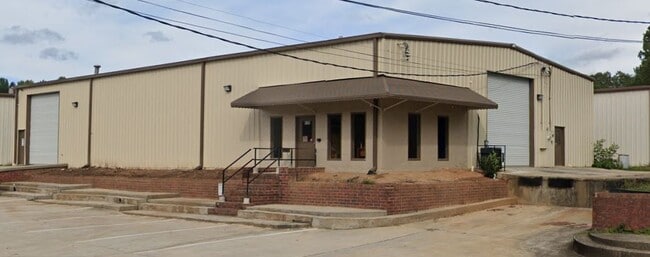


Property Detail
6195 Hotel St
Atlanta-Sandy Springs-Roswell, GA
BLDG/0.311 ACRE, HOTEL ST
6182-02-0-0-052
Douglas
Warehouse
Georgia
B and X Area of moderate flood hazard, usually the area between the limits of the 100-year and 500-year floods.
206
2025
0.31 AC
2025
I-20 W/Douglasville
080106
Atlanta
6,000 SF
NEARBY LISTINGS FOR SALE OR LEASE
DEMOGRAPHICS near 6195 Hotel St
1 mile
3 mile
5 mile
2025 Total Population
4,171
47,452
126,280
2030 Population
4,359
49,141
130,846
Pop Growth 2025-2030
+ 4.51%
+ 3.56%
+ 3.62%
Average Age
37
38
38
2025 Total Households
1,565
17,807
46,513
HH Growth 2025-2030
+ 4.60%
+ 3.47%
+ 3.59%
Median Household Inc
$57,194
$66,934
$73,272
Avg Household Size
2.60
2.60
2.60
2025 Avg HH Vehicles
2.00
2.00
2.00
Median Home Value
$244,527
$280,904
$309,551
Median Year Built
1988
1989
1987
Nearby Places
Map Layers
Map Styles
 Street
 Aerial
Layers
 Traffic
 Biking
Places
Listings with unknown addresses are not visible on the map
- Restaurants
- Banks
- Shops
- Fitness
- Groceries
PUBLIC TRANSPORTATION
AIRPORT
Hartsfield - Jackson Atlanta International
Drive
Walk
Distance
Hartsfield - Jackson Atlanta International
37 min
24.9 mi
SALE & LEASE HISTORY
LISTING DATE
SALE/LEASE

Dec 16, 2020
For Lease
Nearby Properties
Address
Land Use
TOTAL SIZE
Lot Size
Zoning
Address
Land Use
TOTAL SIZE
Lot Size
Zoning
603,952 SF
37.71 AC
IL
Address
Land Use
TOTAL SIZE
Lot Size
Zoning
840,110 SF
53.36 AC
PUD
Address
Land Use
TOTAL SIZE
Lot Size
Zoning
320,073 SF
38.78 AC
R-MF
Address
Land Use
TOTAL SIZE
Lot Size
Zoning
318,456 SF
30.91 AC
R-MF
Address
Land Use
TOTAL SIZE
Lot Size
Zoning
222,846 SF
50.74 AC
R-6
Address
Land Use
TOTAL SIZE
Lot Size
Zoning
330,754 SF
27.25 AC
R-6
Address
Land Use
TOTAL SIZE
Lot Size
Zoning
266,904 SF
53.52 AC
DCD
Address
Land Use
TOTAL SIZE
Lot Size
Zoning
307,169 SF
30.13 AC
LI
Address
Land Use
TOTAL SIZE
Lot Size
Zoning
285,933 SF
46.22 AC
R-MF
Address
Land Use
TOTAL SIZE
Lot Size
Zoning
281,844 SF
38.66 AC
R-MF
Address
Land Use
TOTAL SIZE
Lot Size
Zoning
635,664 SF
35.94 AC
5
Address
Land Use
TOTAL SIZE
Lot Size
Zoning
245,812 SF
30.90 AC
DCD
Address
Land Use
TOTAL SIZE
Lot Size
Zoning
240,612 SF
23.22 AC
R-6
Address
Land Use
TOTAL SIZE
Lot Size
Zoning
494,858 SF
43.29 AC
IL
Address
Land Use
TOTAL SIZE
Lot Size
Zoning
Address
Land Use
TOTAL SIZE
Lot Size
Zoning
527,000 SF
30.38 AC
LI
Address
Land Use
TOTAL SIZE
Lot Size
Zoning
400,000 SF
66.21 AC
IL
Address
Land Use
TOTAL SIZE
Lot Size
Zoning
380,000 SF
33.97 AC
IL
Address
Land Use
TOTAL SIZE
Lot Size
Zoning
151,436 SF
11.42 AC
RM-12
Address
Land Use
TOTAL SIZE
Lot Size
Zoning
296,942 SF
72.27 AC
IL
Address
Land Use
TOTAL SIZE
Lot Size
Zoning
280,670 SF
23 AC
PVC
Address
Land Use
TOTAL SIZE
Lot Size
Zoning
312,093 SF
19.79 AC
PUD
Address
Land Use
TOTAL SIZE
Lot Size
Zoning
122,697 SF
13.02 AC
PUD
Address
Land Use
TOTAL SIZE
Lot Size
Zoning
312,240 SF
24.58 AC
PUD
Address
Land Use
TOTAL SIZE
Lot Size
Zoning
261,794 SF
2.32 AC
DCD
Address
Land Use
TOTAL SIZE
Lot Size
Zoning
284,307 SF
15.75 AC
LI-R
Address
Land Use
TOTAL SIZE
Lot Size
Zoning
225,600 SF
50.68 AC
LI-R
Address
Land Use
TOTAL SIZE
Lot Size
Zoning
247,000 SF
17.77 AC
PUD
Address
Land Use
TOTAL SIZE
Lot Size
Zoning
78.60 AC
R20
Address
Land Use
TOTAL SIZE
Lot Size
Zoning
182,092 SF
9.70 AC
IL
The World's #1 Commercial Real Estate Marketplace
Connect with us
© 2026 CoStar Group
The information above has been obtained from sources believed reliable. While we do not doubt its accuracy we have not verified it and make no guarantee, warranty or representation about it. It is your responsibility to independently confirm its accuracy and completeness. Any projections, opinions, assumptions, or estimates used are for example only and do not represent the current or future performance of the property. The value of this transaction to you depends on tax and other factors which should be evaluated by your tax, financial, and legal advisors. You and your advisors should conduct a careful, independent investigation of the property to determine to your satisfaction the suitability of the property for your needs.