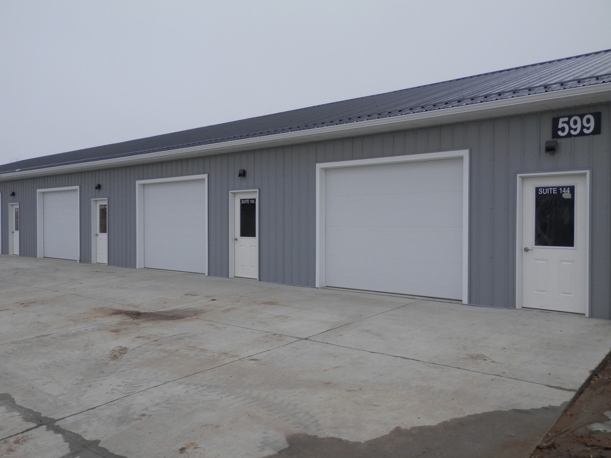
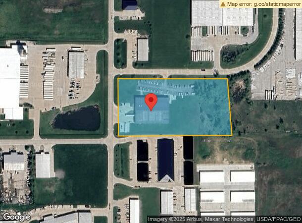
Property Record
6201 S Gateway Dr, Marion, IA 52302
NEARBY LISTINGS FOR SALE OR LEASE
Property Detail
6201 S Gateway Dr
Cedar Rapids, IA
Marion Commerce Pk 1St
15041-02003-00000
MARION COMMERCE PK 1ST LOT 15
Warehouse
Linn
X
Iowa
19113C0316E
15
2023
5 AC
2023
Iowa City/Waterloo
010500
Other Market Areas
30,000 SF
DEMOGRAPHICS near 6201 S Gateway Dr
1 Mile
3 Mile
5 Mile
2024 Total Population
3,147
26,441
55,532
2029 Population
3,179
26,217
55,265
Pop Growth 2024-2029
+ 1.02%
(0.85%)
(0.48%)
Average Age
41
41
41
2024 Total Households
1,310
10,860
22,902
HH Growth 2024-2029
+ 0.99%
(0.87%)
(0.52%)
Median Household Inc
$76,848
$71,573
$73,382
Avg Household Size
2.40
2.40
2.40
2024 Avg HH Vehicles
2.00
2.00
2.00
Median Home Value
$205,059
$189,750
$212,594
Median Year Built
1997
1987
1984
Nearby Places
- Restaurants
- Banks
- Shops
- Fitness
- Groceries
PUBLIC TRANSPORTATION
AIRPORT
The Eastern Iowa
DRIVE
WALK
Distance
The Eastern Iowa
29 min
20.3 mi
Freight Ports
Port Milwaukee
DRIVE
WALK
Distance
Port Milwaukee
279 min
236.6 mi
SALE & LEASE HISTORY
LISTING DATE
SALE/LEASE

Sep 26, 2016
For Lease
Nearby Properties
Address
Land Use
TOTAL SIZE
Lot Size
Zoning
Address
Land Use
TOTAL SIZE
Lot Size
Zoning
585,444 SF
95.41 AC
Address
Land Use
TOTAL SIZE
Lot Size
Zoning
980,058 SF
107.75 AC
Address
Land Use
TOTAL SIZE
Lot Size
Zoning
203,166 SF
14.16 AC
Address
Land Use
TOTAL SIZE
Lot Size
Zoning
50,344 SF
2.92 AC
Address
Land Use
TOTAL SIZE
Lot Size
Zoning
218,390 SF
50.24 AC
Address
Land Use
TOTAL SIZE
Lot Size
Zoning
106,317 SF
4.42 AC
Address
Land Use
TOTAL SIZE
Lot Size
Zoning
155,200 SF
28.66 AC
Address
Land Use
TOTAL SIZE
Lot Size
Zoning
155,185 SF
171 AC
AG
Address
Land Use
TOTAL SIZE
Lot Size
Zoning
36,564 SF
4.22 AC
Address
Land Use
TOTAL SIZE
Lot Size
Zoning
1,007,977 SF
323.91 AC
Address
Land Use
TOTAL SIZE
Lot Size
Zoning
1,440 SF
82.59 AC
Address
Land Use
TOTAL SIZE
Lot Size
Zoning
92,704 SF
10.30 AC
Address
Land Use
TOTAL SIZE
Lot Size
Zoning
204,041 SF
48.90 AC
Address
Land Use
TOTAL SIZE
Lot Size
Zoning
Address
Land Use
TOTAL SIZE
Lot Size
Zoning
24,937 SF
0.74 AC
Address
Land Use
TOTAL SIZE
Lot Size
Zoning
1,728 SF
64.65 AC
Address
Land Use
TOTAL SIZE
Lot Size
Zoning
3,960 SF
5.58 AC
Address
Land Use
TOTAL SIZE
Lot Size
Zoning
110,746 SF
8.72 AC
Address
Land Use
TOTAL SIZE
Lot Size
Zoning
21,235 SF
12.92 AC
Address
Land Use
TOTAL SIZE
Lot Size
Zoning
57,277 SF
6.78 AC
Address
Land Use
TOTAL SIZE
Lot Size
Zoning
86,754 SF
24.45 AC
Address
Land Use
TOTAL SIZE
Lot Size
Zoning
10,534 SF
21.40 AC
Address
Land Use
TOTAL SIZE
Lot Size
Zoning
71.35 AC
Address
Land Use
TOTAL SIZE
Lot Size
Zoning
407,757 SF
70.98 AC
Address
Land Use
TOTAL SIZE
Lot Size
Zoning
22,068 SF
5.06 AC
Address
Land Use
TOTAL SIZE
Lot Size
Zoning
92,652 SF
3.60 AC
Address
Land Use
TOTAL SIZE
Lot Size
Zoning
646,665 SF
60 AC
Address
Land Use
TOTAL SIZE
Lot Size
Zoning
4.62 AC
Address
Land Use
TOTAL SIZE
Lot Size
Zoning
18,421 SF
10.67 AC
Address
Land Use
TOTAL SIZE
Lot Size
Zoning
34,330 SF
6.56 AC
The World's #1 Commercial Real Estate Marketplace
Connect with us
© 2025 CoStar Group
The information above has been obtained from sources believed reliable. While we do not doubt its accuracy we have not verified it and make no guarantee, warranty or representation about it. It is your responsibility to independently confirm its accuracy and completeness. Any projections, opinions, assumptions, or estimates used are for example only and do not represent the current or future performance of the property. The value of this transaction to you depends on tax and other factors which should be evaluated by your tax, financial, and legal advisors. You and your advisors should conduct a careful, independent investigation of the property to determine to your satisfaction the suitability of the property for your needs.