Property Record
6202 S State Rd, Goodrich, MI 48438
NEARBY LISTINGS FOR SALE OR LEASE
-
-
View all Goodrich listings for sale on LoopNet.com
Property Detail
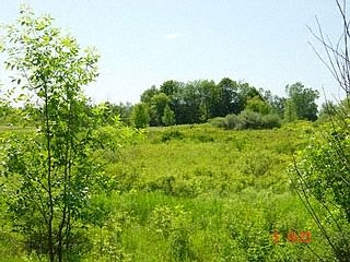
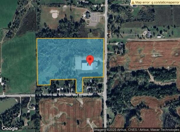
6202 S State Rd
02-10-100-019
A PARCEL OF LAND BEG S 1519.99 FT FROM N 1/4 COR OF SEC TH S 88 DEG 38 MIN 13 SEC W 1352.45 FT TH S 01 DEG 28 MIN 38 SEC E 883.85 FT TH N 87 DEG 59 MIN 18 SEC E 255.3 FT TH N 100 FT TH N 87 DEG 59 MIN 18 SEC E 500 FT TH S 300 FT TH N 87 DEG 59 MIN 18
Industrialgeneral
Genesee
X
Michigan
26049C0334D
24.96 AC
2024
Flint
2024
Detroit
013401
Flint, MI
43,036 SF
DEMOGRAPHICS near 6202 S State Rd
1 Mile
3 Mile
5 Mile
2024 Total Population
369
5,771
25,713
2029 Population
352
5,562
24,951
Pop Growth 2024-2029
(4.61%)
(3.62%)
(2.96%)
Average Age
42
42
41
2024 Total Households
126
2,032
9,812
HH Growth 2024-2029
(4.76%)
(3.64%)
(2.89%)
Median Household Inc
$101,136
$102,489
$89,165
Avg Household Size
2.80
2.80
2.60
2024 Avg HH Vehicles
3.00
3.00
2.00
Median Home Value
$292,390
$283,019
$262,344
Median Year Built
1979
1979
1980
Nearby Places
- Restaurants
- Banks
- Shops
- Fitness
- Groceries
PUBLIC TRANSPORTATION
AIRPORT
Bishop International
DRIVE
WALK
Distance
Bishop International
36 min
22.3 mi
Freight Ports
Port of Toledo
DRIVE
WALK
Distance
Port of Toledo
136 min
101.6 mi
Nearby Properties
Address
Land Use
TOTAL SIZE
Lot Size
Zoning
Address
Land Use
TOTAL SIZE
Lot Size
Zoning
58,215 SF
7.99 AC
C-2
Address
Land Use
TOTAL SIZE
Lot Size
Zoning
12,760 SF
16 AC
VILLAG
Address
Land Use
TOTAL SIZE
Lot Size
Zoning
74,450 SF
13.20 AC
M-1
Address
Land Use
TOTAL SIZE
Lot Size
Zoning
28,288 SF
4.98 AC
VILLAG
Address
Land Use
TOTAL SIZE
Lot Size
Zoning
22,738 SF
147.75 AC
RSA
Address
Land Use
TOTAL SIZE
Lot Size
Zoning
54,720 SF
34.70 AC
VILLAG
Address
Land Use
TOTAL SIZE
Lot Size
Zoning
27,733 SF
4.56 AC
M-1
Address
Land Use
TOTAL SIZE
Lot Size
Zoning
24,311 SF
10 AC
VILLAG
Address
Land Use
TOTAL SIZE
Lot Size
Zoning
12,958 SF
1.30 AC
VILLAG
Address
Land Use
TOTAL SIZE
Lot Size
Zoning
12,202 SF
0.83 AC
VILLAG
Address
Land Use
TOTAL SIZE
Lot Size
Zoning
12,696 SF
110.42 AC
VILLAG
Address
Land Use
TOTAL SIZE
Lot Size
Zoning
5,292 SF
0.73 AC
VILLAG
Address
Land Use
TOTAL SIZE
Lot Size
Zoning
1,593 SF
194.67 AC
NOT AVAILA
Address
Land Use
TOTAL SIZE
Lot Size
Zoning
9,840 SF
1.21 AC
VILLAG
Address
Land Use
TOTAL SIZE
Lot Size
Zoning
17,642 SF
1.67 AC
VILLAG
Address
Land Use
TOTAL SIZE
Lot Size
Zoning
22,076 SF
5.06 AC
VILLAG
Address
Land Use
TOTAL SIZE
Lot Size
Zoning
12,057 SF
0.86 AC
VILLAG
Address
Land Use
TOTAL SIZE
Lot Size
Zoning
6,000 SF
0.85 AC
VILLAG
Address
Land Use
TOTAL SIZE
Lot Size
Zoning
3,096 SF
4.68 AC
VILLAG
Address
Land Use
TOTAL SIZE
Lot Size
Zoning
241.34 AC
RA
Address
Land Use
TOTAL SIZE
Lot Size
Zoning
2,582 SF
74.31 AC
NOT AVAILA
Address
Land Use
TOTAL SIZE
Lot Size
Zoning
3,421 SF
2.14 AC
VILLAG
Address
Land Use
TOTAL SIZE
Lot Size
Zoning
1,728 SF
100 AC
NOT AVAILA
Address
Land Use
TOTAL SIZE
Lot Size
Zoning
4,960 SF
0.40 AC
VILLAG
Address
Land Use
TOTAL SIZE
Lot Size
Zoning
3,682 SF
0.32 AC
VILLAG
Address
Land Use
TOTAL SIZE
Lot Size
Zoning
6,080 SF
6.44 AC
C-3
Address
Land Use
TOTAL SIZE
Lot Size
Zoning
2,903 SF
0.99 AC
VILLAG
Address
Land Use
TOTAL SIZE
Lot Size
Zoning
6,000 SF
6.45 AC
C-2
Address
Land Use
TOTAL SIZE
Lot Size
Zoning
13.77 AC
The World's #1 Commercial Real Estate Marketplace
Connect with us
© 2025 CoStar Group
The information above has been obtained from sources believed reliable. While we do not doubt its accuracy we have not verified it and make no guarantee, warranty or representation about it. It is your responsibility to independently confirm its accuracy and completeness. Any projections, opinions, assumptions, or estimates used are for example only and do not represent the current or future performance of the property. The value of this transaction to you depends on tax and other factors which should be evaluated by your tax, financial, and legal advisors. You and your advisors should conduct a careful, independent investigation of the property to determine to your satisfaction the suitability of the property for your needs.