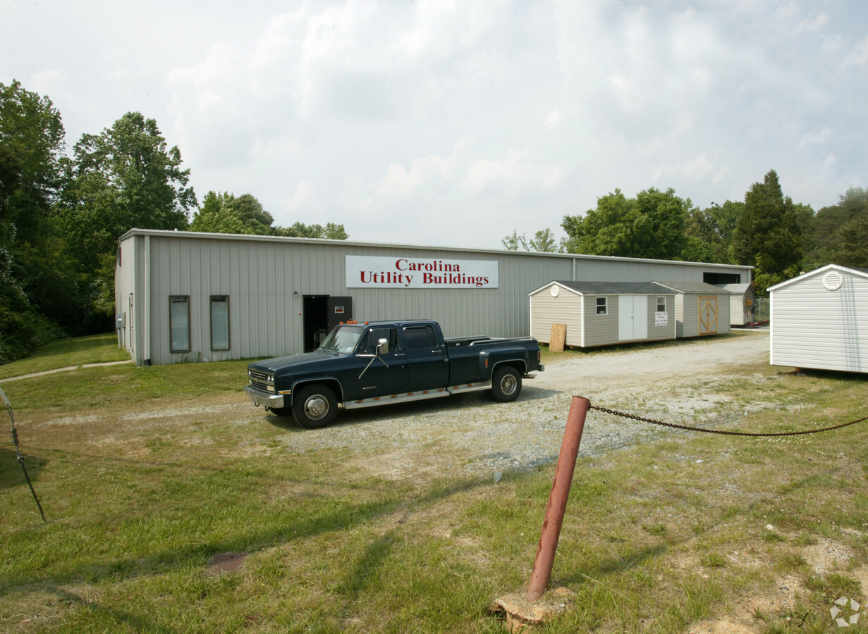
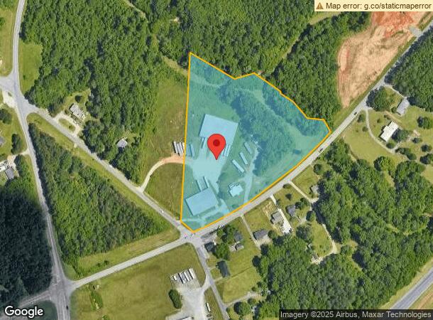
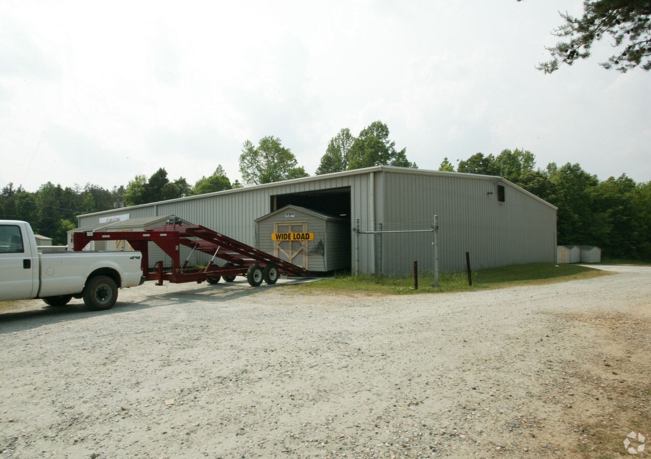
Property Record
6219 Nc Highway 62, Trinity, NC 27370
NEARBY LISTINGS FOR SALE OR LEASE
Property Detail
6219 Nc Highway 62
7707-27-7415
R62;R1882
Warehouse
Randolph
AE
North Carolina
3710770700J
7.11 AC
2024
NW Randolph Cnty/Archdale
2024
Greensboro/Winston-Salem
031601
Greensboro-High Point, NC
10,000 SF
DEMOGRAPHICS near 6219 Nc Highway 62
1 Mile
3 Mile
5 Mile
2024 Total Population
1,069
15,215
68,191
2029 Population
1,112
15,815
70,597
Pop Growth 2024-2029
+ 4.02%
+ 3.94%
+ 3.53%
Average Age
44
43
40
2024 Total Households
438
6,293
27,099
HH Growth 2024-2029
+ 3.88%
+ 3.80%
+ 3.48%
Median Household Inc
$63,750
$61,479
$51,886
Avg Household Size
2.40
2.40
2.40
2024 Avg HH Vehicles
2.00
2.00
2.00
Median Home Value
$164,515
$161,619
$151,202
Median Year Built
1979
1981
1977
Nearby Places
- Restaurants
- Banks
- Shops
- Fitness
- Groceries
PUBLIC TRANSPORTATION
COMMUTER RAIL
High Point Station (Piedmont - North Carolina by Train (NC Train))
DRIVE
WALK
Distance
High Point Station (Piedmont - North Carolina by Train (NC Train))
12 min
6.5 mi
AIRPORT
Piedmont Triad International
DRIVE
WALK
Distance
Piedmont Triad International
35 min
24.6 mi
Freight Ports
Port of Wilmington
DRIVE
WALK
Distance
Port of Wilmington
250 min
210.3 mi
Nearby Properties
Address
Land Use
TOTAL SIZE
Lot Size
Zoning
Address
Land Use
TOTAL SIZE
Lot Size
Zoning
7,898 SF
68.51 AC
M2
Address
Land Use
TOTAL SIZE
Lot Size
Zoning
355,633 SF
63.42 AC
HI
Address
Land Use
TOTAL SIZE
Lot Size
Zoning
351,736 SF
34.77 AC
HI
Address
Land Use
TOTAL SIZE
Lot Size
Zoning
127,800 SF
57.35 AC
M1
Address
Land Use
TOTAL SIZE
Lot Size
Zoning
245,194 SF
23.44 AC
LI
Address
Land Use
TOTAL SIZE
Lot Size
Zoning
127,280 SF
29.10 AC
M2CZ
Address
Land Use
TOTAL SIZE
Lot Size
Zoning
2,128 SF
20.06 AC
M1
Address
Land Use
TOTAL SIZE
Lot Size
Zoning
109,950 SF
28.29 AC
M1
Address
Land Use
TOTAL SIZE
Lot Size
Zoning
28.20 AC
R40
Address
Land Use
TOTAL SIZE
Lot Size
Zoning
43,000 SF
8.63 AC
C2
Address
Land Use
TOTAL SIZE
Lot Size
Zoning
150,970 SF
36.21 AC
M1
Address
Land Use
TOTAL SIZE
Lot Size
Zoning
45,224 SF
8.03 AC
OI
Address
Land Use
TOTAL SIZE
Lot Size
Zoning
104,623 SF
55.13 AC
R40
Address
Land Use
TOTAL SIZE
Lot Size
Zoning
5,040 SF
14.88 AC
HI
Address
Land Use
TOTAL SIZE
Lot Size
Zoning
9.70 AC
R40
Address
Land Use
TOTAL SIZE
Lot Size
Zoning
99,649 SF
15.58 AC
CU-HI
Address
Land Use
TOTAL SIZE
Lot Size
Zoning
240,510 SF
4.60 AC
LI
Address
Land Use
TOTAL SIZE
Lot Size
Zoning
246,972 SF
19.83 AC
HI
Address
Land Use
TOTAL SIZE
Lot Size
Zoning
8,927 SF
3.60 AC
OI
Address
Land Use
TOTAL SIZE
Lot Size
Zoning
42,262 SF
6.73 AC
M1
Address
Land Use
TOTAL SIZE
Lot Size
Zoning
114,220 SF
69.22 AC
M1
Address
Land Use
TOTAL SIZE
Lot Size
Zoning
99,722 SF
38.13 AC
M2
Address
Land Use
TOTAL SIZE
Lot Size
Zoning
202,416 SF
11.45 AC
M1
Address
Land Use
TOTAL SIZE
Lot Size
Zoning
43,328 SF
2.11 AC
B1
Address
Land Use
TOTAL SIZE
Lot Size
Zoning
4,000 SF
6.41 AC
HI
Address
Land Use
TOTAL SIZE
Lot Size
Zoning
37,680 SF
1.66 AC
CD HB
Address
Land Use
TOTAL SIZE
Lot Size
Zoning
15,522 SF
167.47 AC
R40
Address
Land Use
TOTAL SIZE
Lot Size
Zoning
18.23 AC
R15
Address
Land Use
TOTAL SIZE
Lot Size
Zoning
5,280 SF
16.74 AC
RA
Address
Land Use
TOTAL SIZE
Lot Size
Zoning
12,288 SF
4.10 AC
O&ICZ
The World's #1 Commercial Real Estate Marketplace
Connect with us
© 2025 CoStar Group
The information above has been obtained from sources believed reliable. While we do not doubt its accuracy we have not verified it and make no guarantee, warranty or representation about it. It is your responsibility to independently confirm its accuracy and completeness. Any projections, opinions, assumptions, or estimates used are for example only and do not represent the current or future performance of the property. The value of this transaction to you depends on tax and other factors which should be evaluated by your tax, financial, and legal advisors. You and your advisors should conduct a careful, independent investigation of the property to determine to your satisfaction the suitability of the property for your needs.