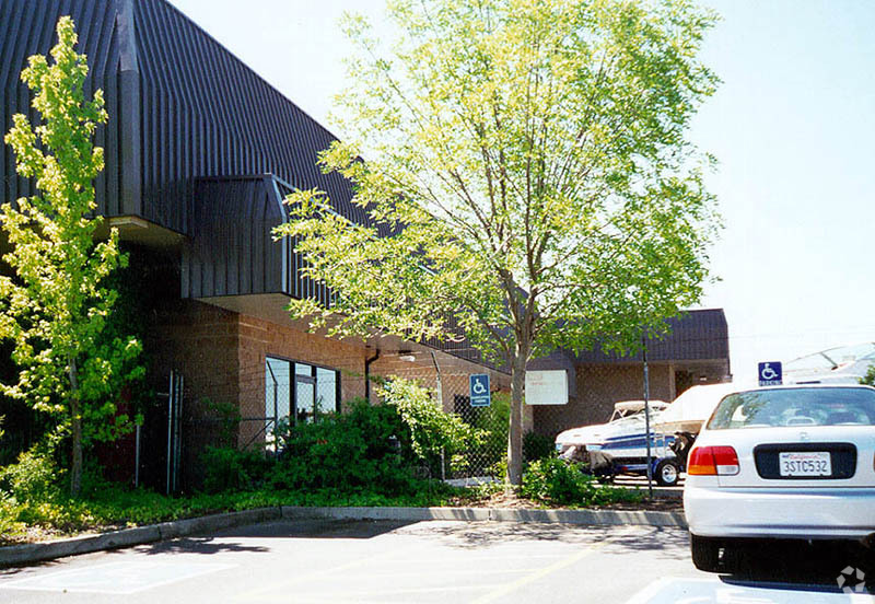
Property Record
6233 Blacktop Rd, Rio Linda, CA 95673
NEARBY LISTINGS FOR SALE OR LEASE
Property Detail
6233 Blacktop Rd
Sacramento--Roseville--Arden-Arcade, CA
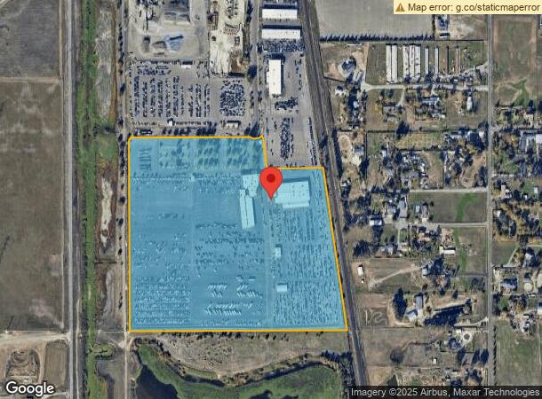
Parcel Map
214-0290-037
PARCEL1-15
Commercialnec
Sacramento
AE
California
06067C0061J
2
2023
41.26 AC
2024
Natomas/Northgate
007106
Sacramento
70,114 SF
DEMOGRAPHICS near 6233 Blacktop Rd
1 Mile
3 Mile
5 Mile
2024 Total Population
3,996
70,510
190,029
2029 Population
3,987
71,110
191,618
Pop Growth 2024-2029
(0.23%)
+ 0.85%
+ 0.84%
Average Age
37
37
37
2024 Total Households
1,298
23,437
62,579
HH Growth 2024-2029
(0.23%)
+ 0.90%
+ 0.82%
Median Household Inc
$89,903
$96,423
$84,153
Avg Household Size
3.00
3.00
2.90
2024 Avg HH Vehicles
2.00
2.00
2.00
Median Home Value
$461,854
$480,573
$442,551
Median Year Built
2002
2001
1993
Nearby Places
- Restaurants
- Banks
- Shops
- Fitness
- Groceries
PUBLIC TRANSPORTATION
AIRPORT
Sacramento International
DRIVE
WALK
Distance
Sacramento International
15 min
9.1 mi
Freight Ports
Port of Stockton
DRIVE
WALK
Distance
Port of Stockton
68 min
57.5 mi
Nearby Properties
Address
Land Use
TOTAL SIZE
Lot Size
Zoning
Address
Land Use
TOTAL SIZE
Lot Size
Zoning
200,000 SF
8.48 AC
M-1
Address
Land Use
TOTAL SIZE
Lot Size
Zoning
153,090 SF
7.77 AC
MP
Address
Land Use
TOTAL SIZE
Lot Size
Zoning
241,321 SF
14.43 AC
R-3-PUD
Address
Land Use
TOTAL SIZE
Lot Size
Zoning
388,609 SF
14.67 AC
R-3-PUD
Address
Land Use
TOTAL SIZE
Lot Size
Zoning
429,346 SF
18.88 AC
R-2B-PUD E
Address
Land Use
TOTAL SIZE
Lot Size
Zoning
298,493 SF
18.56 AC
EC-40-PUD
Address
Land Use
TOTAL SIZE
Lot Size
Zoning
209,386 SF
8.57 AC
M-1
Address
Land Use
TOTAL SIZE
Lot Size
Zoning
164,061 SF
8.15 AC
R-3-PUD
Address
Land Use
TOTAL SIZE
Lot Size
Zoning
9.01 AC
EC-80-PUD
Address
Land Use
TOTAL SIZE
Lot Size
Zoning
92,240 SF
5.59 AC
MP
Address
Land Use
TOTAL SIZE
Lot Size
Zoning
217,682 SF
9.57 AC
R-3-PUD
Address
Land Use
TOTAL SIZE
Lot Size
Zoning
168,147 SF
10.10 AC
SC-PUD
Address
Land Use
TOTAL SIZE
Lot Size
Zoning
209,376 SF
9.14 AC
MP M-1
Address
Land Use
TOTAL SIZE
Lot Size
Zoning
222,792 SF
12.50 AC
MP
Address
Land Use
TOTAL SIZE
Lot Size
Zoning
1,784 SF
15.07 AC
M-1
Address
Land Use
TOTAL SIZE
Lot Size
Zoning
343,355 SF
19.10 AC
M-1 MP
Address
Land Use
TOTAL SIZE
Lot Size
Zoning
264,620 SF
0.68 AC
R-4-PUD
Address
Land Use
TOTAL SIZE
Lot Size
Zoning
264,620 SF
8.89 AC
R-4-PUD
Address
Land Use
TOTAL SIZE
Lot Size
Zoning
100.41 AC
C-2-PUD
Address
Land Use
TOTAL SIZE
Lot Size
Zoning
4.01 AC
C-2-PUD
Address
Land Use
TOTAL SIZE
Lot Size
Zoning
8.05 AC
R-3-PUD R-
Address
Land Use
TOTAL SIZE
Lot Size
Zoning
134,421 SF
10.15 AC
SC-PUD
Address
Land Use
TOTAL SIZE
Lot Size
Zoning
108,400 SF
5.51 AC
M-1S-R
Address
Land Use
TOTAL SIZE
Lot Size
Zoning
181,820 SF
8.44 AC
R-3-PUD
Address
Land Use
TOTAL SIZE
Lot Size
Zoning
246,000 SF
13.39 AC
M-1
Address
Land Use
TOTAL SIZE
Lot Size
Zoning
249,883 SF
15.63 AC
M-1
Address
Land Use
TOTAL SIZE
Lot Size
Zoning
431,031 SF
53.64 AC
C-2-PUD
Address
Land Use
TOTAL SIZE
Lot Size
Zoning
508.98 AC
AG-80
Address
Land Use
TOTAL SIZE
Lot Size
Zoning
111,360 SF
5.90 AC
MP
Address
Land Use
TOTAL SIZE
Lot Size
Zoning
193,000 SF
13.81 AC
MP M-1
The World's #1 Commercial Real Estate Marketplace
Connect with us
© 2025 CoStar Group
The information above has been obtained from sources believed reliable. While we do not doubt its accuracy we have not verified it and make no guarantee, warranty or representation about it. It is your responsibility to independently confirm its accuracy and completeness. Any projections, opinions, assumptions, or estimates used are for example only and do not represent the current or future performance of the property. The value of this transaction to you depends on tax and other factors which should be evaluated by your tax, financial, and legal advisors. You and your advisors should conduct a careful, independent investigation of the property to determine to your satisfaction the suitability of the property for your needs.