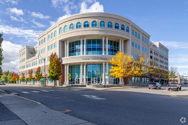
Property Record
626 8Th Ave Se, Olympia, WA 98501
NEARBY LISTINGS FOR SALE OR LEASE
Property Detail
626 8Th Ave Se
Olympia-Tumwater, WA
Swans Addition To Olympia
78200800100
SECTION 14 TOWNSHIP 18 RANGE 2W PLAT SWANS ADDITION TO OLYMPIA BLK 8 LT 1 - 8 DOCUMENT 001/037 LESS MINERAL RIGHTS TGW VAC ALLEY ORD #5727 3125614
Commercialnec
Thurston
X
Washington
53067C0167F
1-8
2024
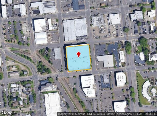
1.38 AC
2024
Downtown Olympia
011721
Olympia
192,981 SF
DEMOGRAPHICS near 626 8Th Ave Se
1 Mile
3 Mile
5 Mile
2024 Total Population
9,499
72,413
139,005
2029 Population
10,095
76,431
146,929
Pop Growth 2024-2029
+ 6.27%
+ 5.55%
+ 5.70%
Average Age
42
41
41
2024 Total Households
5,139
31,763
58,269
HH Growth 2024-2029
+ 6.87%
+ 5.70%
+ 5.86%
Median Household Inc
$65,276
$69,454
$74,346
Avg Household Size
1.80
2.20
2.30
2024 Avg HH Vehicles
1.00
2.00
2.00
Median Home Value
$427,205
$415,736
$408,214
Median Year Built
1971
1983
1986
Nearby Places
Map Layers
Map Styles
 Street
 Aerial
- Restaurants
- Banks
- Shops
- Fitness
- Groceries
PUBLIC TRANSPORTATION
COMMUTER RAIL
DRIVE
WALK
Distance
18 min
7.9 mi
AIRPORT
Seattle-Tacoma International
DRIVE
WALK
Distance
Seattle-Tacoma International
69 min
49.6 mi
Freight Ports
Port of Tacoma
DRIVE
WALK
Distance
Port of Tacoma
42 min
31.2 mi
Nearby Properties
Address
Land Use
TOTAL SIZE
Lot Size
Zoning
Address
Land Use
TOTAL SIZE
Lot Size
Zoning
1,446,648 SF
8.29 AC
CAP
Address
Land Use
TOTAL SIZE
Lot Size
Zoning
830,626 SF
21.53 AC
CAP
Address
Land Use
TOTAL SIZE
Lot Size
Zoning
523,407 SF
86.49 AC
R-4-8
Address
Land Use
TOTAL SIZE
Lot Size
Zoning
874,760 SF
28.63 AC
MS
Address
Land Use
TOTAL SIZE
Lot Size
Zoning
485,918 SF
6.64 AC
CAP
Address
Land Use
TOTAL SIZE
Lot Size
Zoning
6,928 SF
1.33 AC
UW
Address
Land Use
TOTAL SIZE
Lot Size
Zoning
784,559 SF
13.09 AC
CAP
Address
Land Use
TOTAL SIZE
Lot Size
Zoning
98,652 SF
95.43 AC
UW
Address
Land Use
TOTAL SIZE
Lot Size
Zoning
288,270 SF
11.88 AC
CAP
Address
Land Use
TOTAL SIZE
Lot Size
Zoning
179,860 SF
1.28 AC
CAP
Address
Land Use
TOTAL SIZE
Lot Size
Zoning
203,039 SF
38.05 AC
OSI-S
Address
Land Use
TOTAL SIZE
Lot Size
Zoning
353,503 SF
36.94 AC
MFM
Address
Land Use
TOTAL SIZE
Lot Size
Zoning
213,177 SF
1.28 AC
CAP
Address
Land Use
TOTAL SIZE
Lot Size
Zoning
602,509 SF
49.48 AC
HDC-4
Address
Land Use
TOTAL SIZE
Lot Size
Zoning
151,657 SF
2.62 AC
MS
Address
Land Use
TOTAL SIZE
Lot Size
Zoning
235,042 SF
17.16 AC
MFM
Address
Land Use
TOTAL SIZE
Lot Size
Zoning
175,178 SF
36.69 AC
R-4-8
Address
Land Use
TOTAL SIZE
Lot Size
Zoning
114,331 SF
1.43 AC
CAP
Address
Land Use
TOTAL SIZE
Lot Size
Zoning
243,845 SF
12.58 AC
RM-24
Address
Land Use
TOTAL SIZE
Lot Size
Zoning
273,091 SF
17.87 AC
PO/RM
Address
Land Use
TOTAL SIZE
Lot Size
Zoning
204,136 SF
11.91 AC
RM-24
Address
Land Use
TOTAL SIZE
Lot Size
Zoning
94,349 SF
6.02 AC
CAP
Address
Land Use
TOTAL SIZE
Lot Size
Zoning
147,156 SF
18.75 AC
MS
Address
Land Use
TOTAL SIZE
Lot Size
Zoning
217,366 SF
10.88 AC
RM-24
Address
Land Use
TOTAL SIZE
Lot Size
Zoning
155,495 SF
1.06 AC
UWH
Address
Land Use
TOTAL SIZE
Lot Size
Zoning
197,571 SF
52.35 AC
R-4-8
Address
Land Use
TOTAL SIZE
Lot Size
Zoning
266,887 SF
1.38 AC
UW
Address
Land Use
TOTAL SIZE
Lot Size
Zoning
241,689 SF
10.75 AC
RM-24
Address
Land Use
TOTAL SIZE
Lot Size
Zoning
175,938 SF
13 AC
MFM
The World's #1 Commercial Real Estate Marketplace
Connect with us
© 2025 CoStar Group
The information above has been obtained from sources believed reliable. While we do not doubt its accuracy we have not verified it and make no guarantee, warranty or representation about it. It is your responsibility to independently confirm its accuracy and completeness. Any projections, opinions, assumptions, or estimates used are for example only and do not represent the current or future performance of the property. The value of this transaction to you depends on tax and other factors which should be evaluated by your tax, financial, and legal advisors. You and your advisors should conduct a careful, independent investigation of the property to determine to your satisfaction the suitability of the property for your needs.