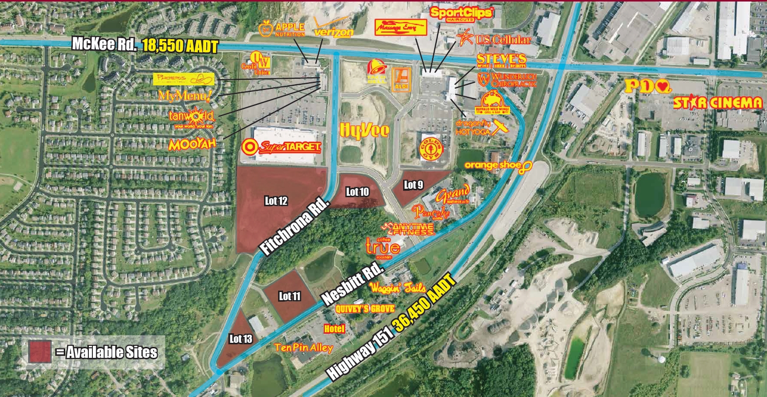
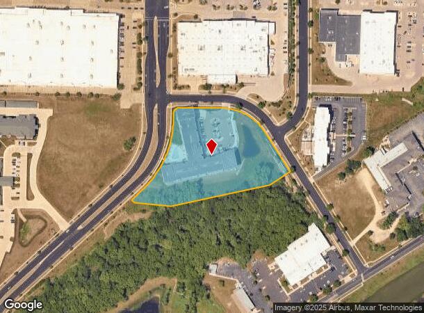
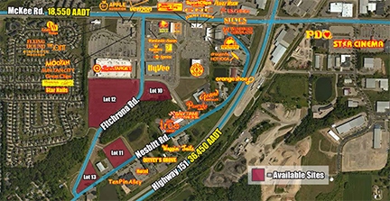
Property Record
6270 Limestone Ln, Madison, WI 53719
NEARBY LISTINGS FOR SALE OR LEASE
Property Detail
6270 Limestone Ln
Madison, WI
Orchard Pointe
0609-072-0070-2
ORCHARD POINTE LOT 10
Commercialnec
Dane
X
Wisconsin
55025C0413G
10
2023
3.79 AC
2023
Southwest Madison
010702
Milwaukee/Madison
DEMOGRAPHICS near 6270 Limestone Ln
1 Mile
3 Mile
5 Mile
2024 Total Population
8,901
68,194
156,806
2029 Population
9,194
70,657
162,951
Pop Growth 2024-2029
+ 3.29%
+ 3.61%
+ 3.92%
Average Age
36
38
39
2024 Total Households
3,654
28,862
70,031
HH Growth 2024-2029
+ 3.34%
+ 3.77%
+ 4.08%
Median Household Inc
$90,659
$88,887
$85,107
Avg Household Size
2.40
2.30
2.20
2024 Avg HH Vehicles
2.00
2.00
2.00
Median Home Value
$301,285
$336,343
$364,905
Median Year Built
1992
1990
1988
Nearby Places
- Restaurants
- Banks
- Shops
- Fitness
- Groceries
PUBLIC TRANSPORTATION
AIRPORT
Dane County Regional/Truax Field
DRIVE
WALK
Distance
Dane County Regional/Truax Field
26 min
12.2 mi
Freight Ports
Port Milwaukee
DRIVE
WALK
Distance
Port Milwaukee
107 min
88.9 mi
SALE & LEASE HISTORY
LISTING DATE
SALE/LEASE

Sep 24, 2016
For Sale
Nearby Properties
Address
Land Use
TOTAL SIZE
Lot Size
Zoning
Address
Land Use
TOTAL SIZE
Lot Size
Zoning
56,000 SF
23.87 AC
SE
Address
Land Use
TOTAL SIZE
Lot Size
Zoning
87.45 AC
Address
Land Use
TOTAL SIZE
Lot Size
Zoning
16.87 AC
SE
Address
Land Use
TOTAL SIZE
Lot Size
Zoning
77,296 SF
4.84 AC
TR-U1
Address
Land Use
TOTAL SIZE
Lot Size
Zoning
16.45 AC
Address
Land Use
TOTAL SIZE
Lot Size
Zoning
27,201 SF
7.65 AC
TR-U2
Address
Land Use
TOTAL SIZE
Lot Size
Zoning
27,201 SF
10.08 AC
TR-U2
Address
Land Use
TOTAL SIZE
Lot Size
Zoning
Address
Land Use
TOTAL SIZE
Lot Size
Zoning
17.80 AC
Address
Land Use
TOTAL SIZE
Lot Size
Zoning
324,920 SF
8.47 AC
PD
Address
Land Use
TOTAL SIZE
Lot Size
Zoning
8.10 AC
Address
Land Use
TOTAL SIZE
Lot Size
Zoning
311,672 SF
4.59 AC
PD
Address
Land Use
TOTAL SIZE
Lot Size
Zoning
125,786 SF
5.62 AC
A
Address
Land Use
TOTAL SIZE
Lot Size
Zoning
13.87 AC
Address
Land Use
TOTAL SIZE
Lot Size
Zoning
237,225 SF
1.84 AC
PD
Address
Land Use
TOTAL SIZE
Lot Size
Zoning
13.98 AC
Address
Land Use
TOTAL SIZE
Lot Size
Zoning
70,258 SF
14.37 AC
PD
Address
Land Use
TOTAL SIZE
Lot Size
Zoning
244,074 SF
7.96 AC
SR-V2
Address
Land Use
TOTAL SIZE
Lot Size
Zoning
15.20 AC
Address
Land Use
TOTAL SIZE
Lot Size
Zoning
3.45 AC
SR-V2
Address
Land Use
TOTAL SIZE
Lot Size
Zoning
236,626 SF
5.63 AC
PD
Address
Land Use
TOTAL SIZE
Lot Size
Zoning
22.45 AC
Address
Land Use
TOTAL SIZE
Lot Size
Zoning
81,373 SF
8.16 AC
CC
Address
Land Use
TOTAL SIZE
Lot Size
Zoning
91,810 SF
6.76 AC
CC
Address
Land Use
TOTAL SIZE
Lot Size
Zoning
126,998 SF
6.56 AC
SE
Address
Land Use
TOTAL SIZE
Lot Size
Zoning
82,796 SF
9.26 AC
SE
Address
Land Use
TOTAL SIZE
Lot Size
Zoning
6.65 AC
Address
Land Use
TOTAL SIZE
Lot Size
Zoning
Address
Land Use
TOTAL SIZE
Lot Size
Zoning
89,000 SF
9.21 AC
CC
Address
Land Use
TOTAL SIZE
Lot Size
Zoning
168,118 SF
17.22 AC
CC
The World's #1 Commercial Real Estate Marketplace
Connect with us
© 2025 CoStar Group
The information above has been obtained from sources believed reliable. While we do not doubt its accuracy we have not verified it and make no guarantee, warranty or representation about it. It is your responsibility to independently confirm its accuracy and completeness. Any projections, opinions, assumptions, or estimates used are for example only and do not represent the current or future performance of the property. The value of this transaction to you depends on tax and other factors which should be evaluated by your tax, financial, and legal advisors. You and your advisors should conduct a careful, independent investigation of the property to determine to your satisfaction the suitability of the property for your needs.