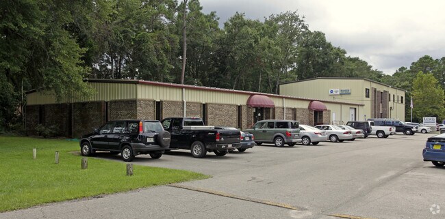
Property Record
630 Capital Cir Ne, Tallahassee, FL 32301

NEARBY LISTINGS FOR SALE OR LEASE
Property Detail
630 Capital Cir Ne
11-33-20-002-000.0
Unplatted Land
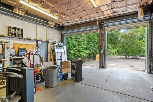
Officebuilding
33 1N 1E IN SE 1/4 OF NE 1/4 OR 966/138 981/1374 1358/1558 OR 1867/1969
A
Leon
12073C0303F
Florida
2025
2.30 AC
2025
East Tallahassee
000904
Tallahassee
17,731 SF
Tallahassee, FL
DEMOGRAPHICS near 630 Capital Cir Ne
1 Mile
3 Mile
5 Mile
2024 Total Population
7,906
57,922
138,348
2029 Population
8,386
61,604
145,789
Pop Growth 2024-2029
+ 6.07%
+ 6.36%
+ 5.38%
Average Age
38
39
37
2024 Total Households
3,639
27,182
60,079
HH Growth 2024-2029
+ 6.98%
+ 6.61%
+ 5.73%
Median Household Inc
$59,945
$63,704
$55,844
Avg Household Size
1.80
2.00
2.10
2024 Avg HH Vehicles
1.00
2.00
2.00
Median Home Value
$179,485
$253,907
$257,379
Median Year Built
1988
1988
1986
Nearby Places
Map Layers
Map Styles
 Street
 Aerial
- Restaurants
- Banks
- Shops
- Fitness
- Groceries
PUBLIC TRANSPORTATION
AIRPORT
Tallahassee International
DRIVE
WALK
Distance
Tallahassee International
20 min
10.6 mi
Freight Ports
Port of Panama City
DRIVE
WALK
Distance
Port of Panama City
149 min
111.0 mi
SALE & LEASE HISTORY
LISTING DATE
SALE/LEASE

May 31, 2022
For Lease
Nearby Properties
Address
Land Use
TOTAL SIZE
Lot Size
Zoning
Address
Land Use
TOTAL SIZE
Lot Size
Zoning
3,882,850 SF
22.64 AC
CM
Address
Land Use
TOTAL SIZE
Lot Size
Zoning
1,906,594 SF
112.75 AC
PUD
Address
Land Use
TOTAL SIZE
Lot Size
Zoning
361,804 SF
14.17 AC
CM
Address
Land Use
TOTAL SIZE
Lot Size
Zoning
577,345 SF
30.63 AC
Address
Land Use
TOTAL SIZE
Lot Size
Zoning
846,072 SF
166.39 AC
R1
Address
Land Use
TOTAL SIZE
Lot Size
Zoning
545,485 SF
14.01 AC
Address
Land Use
TOTAL SIZE
Lot Size
Zoning
200,705 SF
31.57 AC
Address
Land Use
TOTAL SIZE
Lot Size
Zoning
756,595 SF
18.35 AC
Address
Land Use
TOTAL SIZE
Lot Size
Zoning
756,294 SF
20.19 AC
OR3
Address
Land Use
TOTAL SIZE
Lot Size
Zoning
494,919 SF
20.12 AC
R4
Address
Land Use
TOTAL SIZE
Lot Size
Zoning
456,149 SF
22.50 AC
OR3
Address
Land Use
TOTAL SIZE
Lot Size
Zoning
775,087 SF
18.34 AC
Address
Land Use
TOTAL SIZE
Lot Size
Zoning
367,539 SF
26.23 AC
CPA
Address
Land Use
TOTAL SIZE
Lot Size
Zoning
708,504 SF
50.44 AC
PUD
Address
Land Use
TOTAL SIZE
Lot Size
Zoning
380,000 SF
21.78 AC
PUD
Address
Land Use
TOTAL SIZE
Lot Size
Zoning
399,048 SF
19.43 AC
PUD
Address
Land Use
TOTAL SIZE
Lot Size
Zoning
376,746 SF
12.92 AC
OR2
Address
Land Use
TOTAL SIZE
Lot Size
Zoning
473,339 SF
51.93 AC
PUD
Address
Land Use
TOTAL SIZE
Lot Size
Zoning
276,623 SF
20.31 AC
CCPD
Address
Land Use
TOTAL SIZE
Lot Size
Zoning
543,726 SF
13.13 AC
PUD
Address
Land Use
TOTAL SIZE
Lot Size
Zoning
399,815 SF
18.65 AC
Address
Land Use
TOTAL SIZE
Lot Size
Zoning
619,964 SF
6.47 AC
OR3
Address
Land Use
TOTAL SIZE
Lot Size
Zoning
338,619 SF
107.89 AC
GO1
Address
Land Use
TOTAL SIZE
Lot Size
Zoning
606,101 SF
19.01 AC
MR1
Address
Land Use
TOTAL SIZE
Lot Size
Zoning
312,935 SF
11.74 AC
MR1
Address
Land Use
TOTAL SIZE
Lot Size
Zoning
312,935 SF
12.82 AC
MR1
Address
Land Use
TOTAL SIZE
Lot Size
Zoning
456,212 SF
117.40 AC
MR1
Address
Land Use
TOTAL SIZE
Lot Size
Zoning
312,392 SF
14.52 AC
MR1
Address
Land Use
TOTAL SIZE
Lot Size
Zoning
534,652 SF
57.35 AC
MR1
Address
Land Use
TOTAL SIZE
Lot Size
Zoning
247,794 SF
17.24 AC
CP
The World's #1 Commercial Real Estate Marketplace
Connect with us
© 2026 CoStar Group
The information above has been obtained from sources believed reliable. While we do not doubt its accuracy we have not verified it and make no guarantee, warranty or representation about it. It is your responsibility to independently confirm its accuracy and completeness. Any projections, opinions, assumptions, or estimates used are for example only and do not represent the current or future performance of the property. The value of this transaction to you depends on tax and other factors which should be evaluated by your tax, financial, and legal advisors. You and your advisors should conduct a careful, independent investigation of the property to determine to your satisfaction the suitability of the property for your needs.