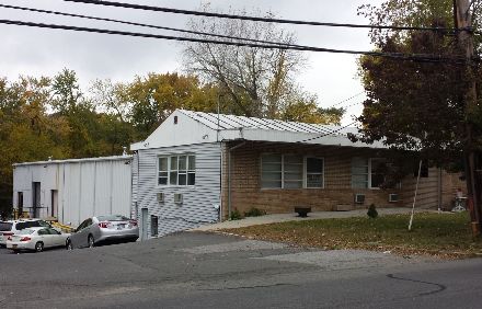
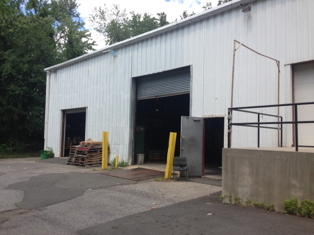
Property Record
630 Saw Mill River Rd, Ardsley, NY 10502
NEARBY LISTINGS FOR SALE OR LEASE
-
-
View all Ardsley listings for sale on LoopNet.com
Property Detail
630 Saw Mill River Rd
New York-Jersey City-White Plains, NY-NJ
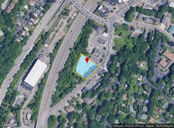
Map Of Lots At Ardsley
2601-006-070-00042-000-0002
Westchester
Warehouse
New York
AE
2.000
36119C0263F
0.88 AC
2024
West I-287 Corridor
2023
Westchester/So Connecticut
010600
DEMOGRAPHICS near 630 Saw Mill River Rd
1 Mile
3 Mile
5 Mile
2024 Total Population
11,859
79,911
285,839
2029 Population
11,564
78,396
280,633
Pop Growth 2024-2029
(2.49%)
(1.90%)
(1.82%)
Average Age
41
43
43
2024 Total Households
4,083
29,700
109,251
HH Growth 2024-2029
(2.74%)
(2.02%)
(1.88%)
Median Household Inc
$173,062
$151,215
$127,158
Avg Household Size
2.80
2.60
2.50
2024 Avg HH Vehicles
2.00
2.00
2.00
Median Home Value
$724,557
$712,735
$651,548
Median Year Built
1958
1956
1957
Nearby Places
- Restaurants
- Banks
- Shops
- Fitness
- Groceries
PUBLIC TRANSPORTATION
COMMUTER RAIL
Dobbs Ferry Station (Hudson Line - Metro-North Commuter Railroad Company (Metro-North))
DRIVE
WALK
Distance
Dobbs Ferry Station (Hudson Line - Metro-North Commuter Railroad Company (Metro-North))
5 min
2.1 mi
Ardsley-On-Hudson Station (Hudson Line - Metro-North Commuter Railroad Company (Metro-North))
DRIVE
WALK
Distance
Ardsley-On-Hudson Station (Hudson Line - Metro-North Commuter Railroad Company (Metro-North))
6 min
2.6 mi
AIRPORT
Westchester County
DRIVE
WALK
Distance
Westchester County
22 min
14.0 mi
Laguardia
DRIVE
WALK
Distance
Laguardia
33 min
21.6 mi
John F Kennedy International
DRIVE
WALK
Distance
John F Kennedy International
43 min
30.2 mi
Freight Ports
NY - Red Hook Container Terminal
DRIVE
WALK
Distance
NY - Red Hook Container Terminal
45 min
29.8 mi
Nearby Properties
Address
Land Use
TOTAL SIZE
Lot Size
Zoning
Address
Land Use
TOTAL SIZE
Lot Size
Zoning
88.45 AC
Address
Land Use
TOTAL SIZE
Lot Size
Zoning
2,736 SF
25.26 AC
Address
Land Use
TOTAL SIZE
Lot Size
Zoning
63.48 AC
R-30
Address
Land Use
TOTAL SIZE
Lot Size
Zoning
66 AC
R-20
Address
Land Use
TOTAL SIZE
Lot Size
Zoning
101.99 AC
Address
Land Use
TOTAL SIZE
Lot Size
Zoning
23.97 AC
Address
Land Use
TOTAL SIZE
Lot Size
Zoning
Address
Land Use
TOTAL SIZE
Lot Size
Zoning
13.22 AC
CA
Address
Land Use
TOTAL SIZE
Lot Size
Zoning
137,822 SF
16.31 AC
Address
Land Use
TOTAL SIZE
Lot Size
Zoning
29.81 AC
Address
Land Use
TOTAL SIZE
Lot Size
Zoning
61.28 AC
Address
Land Use
TOTAL SIZE
Lot Size
Zoning
77.52 AC
A3
Address
Land Use
TOTAL SIZE
Lot Size
Zoning
11.68 AC
Address
Land Use
TOTAL SIZE
Lot Size
Zoning
8.42 AC
Address
Land Use
TOTAL SIZE
Lot Size
Zoning
29.35 AC
Address
Land Use
TOTAL SIZE
Lot Size
Zoning
Address
Land Use
TOTAL SIZE
Lot Size
Zoning
22.44 AC
R-20
Address
Land Use
TOTAL SIZE
Lot Size
Zoning
Address
Land Use
TOTAL SIZE
Lot Size
Zoning
14.92 AC
Address
Land Use
TOTAL SIZE
Lot Size
Zoning
Address
Land Use
TOTAL SIZE
Lot Size
Zoning
1.65 AC
Address
Land Use
TOTAL SIZE
Lot Size
Zoning
64.41 AC
R-20
Address
Land Use
TOTAL SIZE
Lot Size
Zoning
26.50 AC
Address
Land Use
TOTAL SIZE
Lot Size
Zoning
11.18 AC
Address
Land Use
TOTAL SIZE
Lot Size
Zoning
98,910 SF
0.91 AC
VCR-0
Address
Land Use
TOTAL SIZE
Lot Size
Zoning
14.31 AC
Address
Land Use
TOTAL SIZE
Lot Size
Zoning
28.77 AC
Address
Land Use
TOTAL SIZE
Lot Size
Zoning
220,000 SF
2.01 AC
Address
Land Use
TOTAL SIZE
Lot Size
Zoning
16.91 AC
Address
Land Use
TOTAL SIZE
Lot Size
Zoning
18.72 AC
The World's #1 Commercial Real Estate Marketplace
Connect with us
© 2025 CoStar Group
The information above has been obtained from sources believed reliable. While we do not doubt its accuracy we have not verified it and make no guarantee, warranty or representation about it. It is your responsibility to independently confirm its accuracy and completeness. Any projections, opinions, assumptions, or estimates used are for example only and do not represent the current or future performance of the property. The value of this transaction to you depends on tax and other factors which should be evaluated by your tax, financial, and legal advisors. You and your advisors should conduct a careful, independent investigation of the property to determine to your satisfaction the suitability of the property for your needs.