Property Record
6300 Sw Grand Oaks Dr, Corvallis, OR 97333
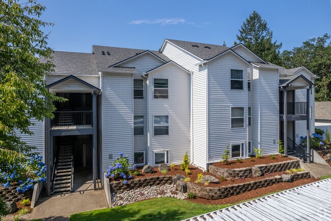


Property Detail
6300 Sw Grand Oaks Dr
408280
LOT 4
Multifamilydwelling
Benton
PD(RS-12)
Oregon
B and X Area of moderate flood hazard, usually the area between the limits of the 100-year and 500-year floods.
4
2025
10.62 AC
2025
Oregon West Area
010900
Other Market Areas
121,330 SF
Corvallis, OR
NEARBY LISTINGS FOR SALE OR LEASE
-
-
View all Corvallis listings for sale on LoopNet.com
DEMOGRAPHICS near 6300 Sw Grand Oaks Dr
1 mile
3 mile
5 mile
2025 Total Population
3,345
48,881
75,573
2030 Population
3,451
51,311
78,519
Pop Growth 2025-2030
+ 3.17%
+ 4.97%
+ 3.90%
Average Age
42
35
37
2025 Total Households
1,385
18,931
30,158
HH Growth 2025-2030
+ 3.10%
+ 5.50%
+ 4.19%
Median Household Inc
$99,999
$59,298
$66,549
Avg Household Size
2.40
2.20
2.20
2025 Avg HH Vehicles
2.00
2.00
2.00
Median Home Value
$659,414
$575,765
$518,781
Median Year Built
1999
1987
1980
Nearby Places
Map Layers
Map Styles
 Street
 Aerial
Layers
 Traffic
 Biking
Places
Listings with unknown addresses are not visible on the map
- Restaurants
- Banks
- Shops
- Fitness
- Groceries
Nearby Properties
Address
Land Use
TOTAL SIZE
Lot Size
Zoning
Address
Land Use
TOTAL SIZE
Lot Size
Zoning
524,658 SF
25.99 AC
RS-12
Address
Land Use
TOTAL SIZE
Lot Size
Zoning
330,690 SF
1.25 AC
MUE
Address
Land Use
TOTAL SIZE
Lot Size
Zoning
104,538 SF
4.38 AC
RS-12
Address
Land Use
TOTAL SIZE
Lot Size
Zoning
208,727 SF
16.20 AC
RS-20
Address
Land Use
TOTAL SIZE
Lot Size
Zoning
166,411 SF
3.04 AC
OSU
Address
Land Use
TOTAL SIZE
Lot Size
Zoning
81,112 SF
1.81 AC
PD(RS-20)
Address
Land Use
TOTAL SIZE
Lot Size
Zoning
241,599 SF
14.33 AC
R-3
Address
Land Use
TOTAL SIZE
Lot Size
Zoning
107,412 SF
9.16 AC
RTC
Address
Land Use
TOTAL SIZE
Lot Size
Zoning
235,104 SF
9.96 AC
PD(RS-20)
Address
Land Use
TOTAL SIZE
Lot Size
Zoning
67,923 SF
4.84 AC
RTC
Address
Land Use
TOTAL SIZE
Lot Size
Zoning
218,015 SF
11.69 AC
PD(RS-12)
Address
Land Use
TOTAL SIZE
Lot Size
Zoning
122,984 SF
2.56 AC
RS-20
Address
Land Use
TOTAL SIZE
Lot Size
Zoning
159,058 SF
13.92 AC
RS-20
Address
Land Use
TOTAL SIZE
Lot Size
Zoning
15.04 AC
RI
Address
Land Use
TOTAL SIZE
Lot Size
Zoning
94,542 SF
10.96 AC
PD(NC-MAJO
Address
Land Use
TOTAL SIZE
Lot Size
Zoning
117,960 SF
5.41 AC
RS-20
Address
Land Use
TOTAL SIZE
Lot Size
Zoning
123,198 SF
6.12 AC
PD(RS-20)
Address
Land Use
TOTAL SIZE
Lot Size
Zoning
109,984 SF
3.51 AC
RS-20
Address
Land Use
TOTAL SIZE
Lot Size
Zoning
53,602 SF
4.83 AC
RTC
Address
Land Use
TOTAL SIZE
Lot Size
Zoning
87,255 SF
3.62 AC
OSU
Address
Land Use
TOTAL SIZE
Lot Size
Zoning
84,170 SF
1.34 AC
RS-20
Address
Land Use
TOTAL SIZE
Lot Size
Zoning
111,577 SF
4.72 AC
RS-20
Address
Land Use
TOTAL SIZE
Lot Size
Zoning
50,575 SF
Address
Land Use
TOTAL SIZE
Lot Size
Zoning
106,912 SF
4.05 AC
PD(RS-12)
Address
Land Use
TOTAL SIZE
Lot Size
Zoning
76,624 SF
3.40 AC
PD(RS-12)
Address
Land Use
TOTAL SIZE
Lot Size
Zoning
Address
Land Use
TOTAL SIZE
Lot Size
Zoning
84,960 SF
5.76 AC
PD(RS-12)
Address
Land Use
TOTAL SIZE
Lot Size
Zoning
98,282 SF
1.38 AC
RS-20
Address
Land Use
TOTAL SIZE
Lot Size
Zoning
103,024 SF
4.53 AC
PD(RS-20)
The World's #1 Commercial Real Estate Marketplace
Connect with us
© 2026 CoStar Group
The information above has been obtained from sources believed reliable. While we do not doubt its accuracy we have not verified it and make no guarantee, warranty or representation about it. It is your responsibility to independently confirm its accuracy and completeness. Any projections, opinions, assumptions, or estimates used are for example only and do not represent the current or future performance of the property. The value of this transaction to you depends on tax and other factors which should be evaluated by your tax, financial, and legal advisors. You and your advisors should conduct a careful, independent investigation of the property to determine to your satisfaction the suitability of the property for your needs.