Property Record
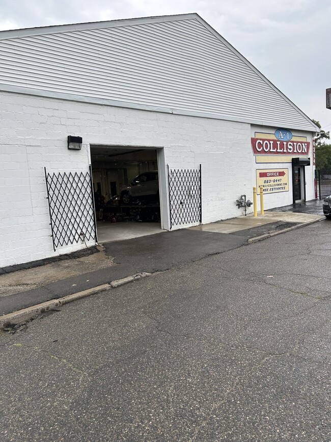
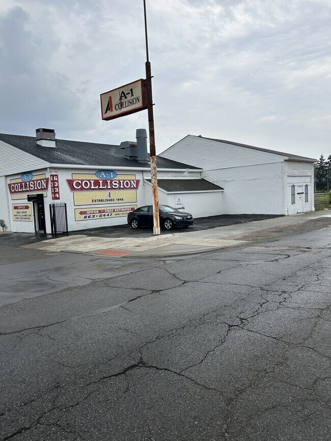
6340 Puritan St, Detroit, MI 48238
NEARBY LISTINGS FOR SALE OR LEASE
Property Detail
6340 Puritan St
16-0078801
Addison Heights
Autorepair
N PURITAN 64 THRU 68 AND VAC ALLEY ADJOINING ADDISON HEIGHTS SUB L34 P53 PLATS W C R 87.54 X 120 69 X 109 ENG CHANGE COMBINED 16007880, 16007881, 16018981, 16018982 ON 9/30/03
X
Wayne
26163C0100E
Michigan
2025
0.40 AC
2025
Detroit W of Woodward
536100
Detroit
5,704 SF
Detroit-Warren-Dearborn, MI
DEMOGRAPHICS near 6340 Puritan St
1 Mile
3 Mile
5 Mile
2024 Total Population
19,907
155,065
442,143
2029 Population
20,068
158,017
444,889
Pop Growth 2024-2029
+ 0.81%
+ 1.90%
+ 0.62%
Average Age
38
40
39
2024 Total Households
7,683
63,357
176,459
HH Growth 2024-2029
+ 1.08%
+ 2.06%
+ 0.87%
Median Household Inc
$38,586
$36,973
$40,293
Avg Household Size
2.40
2.40
2.40
2024 Avg HH Vehicles
1.00
1.00
1.00
Median Home Value
$87,242
$90,486
$100,205
Median Year Built
1947
1948
1948
Nearby Places
Map Layers
Map Styles
 Street
 Aerial
- Restaurants
- Banks
- Shops
- Fitness
- Groceries
PUBLIC TRANSPORTATION
COMMUTER RAIL
DRIVE
WALK
Distance
10 min
5.6 mi
DRIVE
WALK
Distance
17 min
6.6 mi
AIRPORT
Windsor International
DRIVE
WALK
Distance
Windsor International
36 min
17.9 mi
Detroit Metro Wayne County
DRIVE
WALK
Distance
Detroit Metro Wayne County
39 min
26.3 mi
Freight Ports
DRIVE
WALK
Distance
84 min
66.0 mi
Nearby Properties
Address
Land Use
TOTAL SIZE
Lot Size
Zoning
Address
Land Use
TOTAL SIZE
Lot Size
Zoning
925,367 SF
12.82 AC
R6
Address
Land Use
TOTAL SIZE
Lot Size
Zoning
3,529,575 SF
84.46 AC
B4
Address
Land Use
TOTAL SIZE
Lot Size
Zoning
199,592 SF
17.02 AC
B3
Address
Land Use
TOTAL SIZE
Lot Size
Zoning
446,500 SF
27.90 AC
Address
Land Use
TOTAL SIZE
Lot Size
Zoning
165,829 SF
5.56 AC
R5
Address
Land Use
TOTAL SIZE
Lot Size
Zoning
119,418 SF
13.81 AC
B4
Address
Land Use
TOTAL SIZE
Lot Size
Zoning
292,032 SF
20.25 AC
B4
Address
Land Use
TOTAL SIZE
Lot Size
Zoning
353,800 SF
15.70 AC
Address
Land Use
TOTAL SIZE
Lot Size
Zoning
54,672 SF
1.37 AC
R6
Address
Land Use
TOTAL SIZE
Lot Size
Zoning
116,790 SF
5.86 AC
R4
Address
Land Use
TOTAL SIZE
Lot Size
Zoning
90,958 SF
11.78 AC
R5
Address
Land Use
TOTAL SIZE
Lot Size
Zoning
301,000 SF
Address
Land Use
TOTAL SIZE
Lot Size
Zoning
150,689 SF
4.87 AC
R5
Address
Land Use
TOTAL SIZE
Lot Size
Zoning
153,007 SF
7.74 AC
II
Address
Land Use
TOTAL SIZE
Lot Size
Zoning
181,798 SF
10.48 AC
B4
Address
Land Use
TOTAL SIZE
Lot Size
Zoning
63,216 SF
2.87 AC
R5
Address
Land Use
TOTAL SIZE
Lot Size
Zoning
66,870 SF
2.77 AC
Address
Land Use
TOTAL SIZE
Lot Size
Zoning
100,373 SF
5.65 AC
R4
Address
Land Use
TOTAL SIZE
Lot Size
Zoning
23,852 SF
130.56 AC
R1
Address
Land Use
TOTAL SIZE
Lot Size
Zoning
2,216,908 SF
44.80 AC
Address
Land Use
TOTAL SIZE
Lot Size
Zoning
315,973 SF
12.18 AC
M4
Address
Land Use
TOTAL SIZE
Lot Size
Zoning
110,000 SF
1.36 AC
Address
Land Use
TOTAL SIZE
Lot Size
Zoning
81,031 SF
8.15 AC
PD
Address
Land Use
TOTAL SIZE
Lot Size
Zoning
64,566 SF
3.64 AC
PD
Address
Land Use
TOTAL SIZE
Lot Size
Zoning
147,717 SF
8.61 AC
PD
Address
Land Use
TOTAL SIZE
Lot Size
Zoning
7.10 AC
Address
Land Use
TOTAL SIZE
Lot Size
Zoning
91,233 SF
11.36 AC
Address
Land Use
TOTAL SIZE
Lot Size
Zoning
Address
Land Use
TOTAL SIZE
Lot Size
Zoning
155,532 SF
1.72 AC
Address
Land Use
TOTAL SIZE
Lot Size
Zoning
84,453 SF
4.58 AC
The World's #1 Commercial Real Estate Marketplace
Connect with us
© 2025 CoStar Group
The information above has been obtained from sources believed reliable. While we do not doubt its accuracy we have not verified it and make no guarantee, warranty or representation about it. It is your responsibility to independently confirm its accuracy and completeness. Any projections, opinions, assumptions, or estimates used are for example only and do not represent the current or future performance of the property. The value of this transaction to you depends on tax and other factors which should be evaluated by your tax, financial, and legal advisors. You and your advisors should conduct a careful, independent investigation of the property to determine to your satisfaction the suitability of the property for your needs.